
Humanities & GIS Tutorials A Place in History: A Guide to Using GIS in Historical Research Data Archives AHDS: Arts and Humanities Data Service Includes training materials and a large number of case studies in a wide variety of subjects. Other Resources Census Data at Stanford Information on how to find and use Census data from 1790 to the present. Last modified: October 7, 2008 A Roman Excavation These images have been produced by the Museum Education Service in partnership with Carisbrooke Castle Museum as a resource for teachers following a teaching session at your school. Please note that the objects featured here may not be exactly the same as those used in the teaching session. Possible uses of the images could be as follows:• power-point presentations by teachers or pupilsâ?¢ a recap of the session with the chance to draw out particular teaching pointsâ?¢ to show additional material which may have been omitted on the visit â? Copies of these images may be printed by Isle of Wight schools for their own educational use. They may not be published or reproduced for any other purpose without prior written permission from Carisbrooke Castle Museum Trust and the Museum Education Service, Carisbrooke Castle Museum, Newport, Isle of Wight, PO30 1XY Download teacher's notes (pdf) Modern Victorian Georgian Stuart Tudor Medieval Viking Anglo-Saxon Roman
About our Map images In our 'Map images' resource you can access and view over 86,000 maps as high-resolution, colour, zoomable images. The maps date between 1560 and 1961 and relate primarily to Scotland. We also have maps of areas beyond Scotland, including maps of England and Great Britain, Ireland, and Belgium. Find by Place The easiest way of finding material relating to any particular location is to find by place. Browse by category The easiest way of finding general groups of maps is to browse by category. You can also browse the maps by the names of map-makers, surveyors and engravers. Sets of county maps We have several atlases online with sets of county maps: Military maps Another category is of maps made for military purposes, especially those from the 18th century. Ordnance Survey maps We have a comprehensive set of all the detailed Ordnance Survey maps covering Scotland available. Ordnance Survey mapping published in the last 50 years is in copyright and cannot be scanned and made available online.
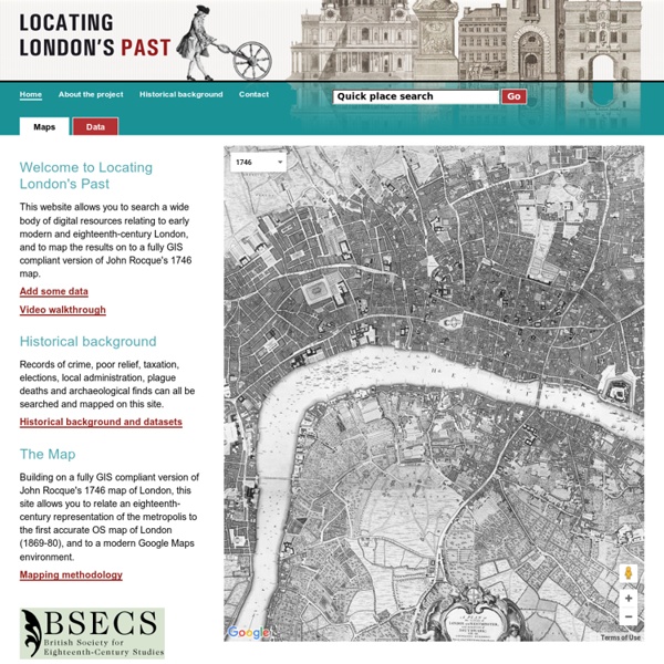
Coordinate converter Convert British National Grid (BNG) formerly known as the National Grid Reference (NGR) to latitude and longitude (lat/long WGS84) or vice versa. See The National Grid FAQs for an explanation of how the BNG works. This coordinate converter uses the Oracle Spatial 10g coordinate transformations using approved (recommended) EPSG codes for BNG, WGS84 and ETRS89, which are 27700, 4326 and 4258 respectively. Technical details . Convert BNG to lat/long Enter a British National Grid six figure number for both easting and northing to return decimal latitude and longitude. Convert lat/long to BNG Enter decimal latitude and longitude to return a six figure number for both easting and northing of the British National Grid. London Lives, 1690-1800: Crime, Poverty and Social Policy in the Metropolis | LOCATING LONDON'S PAST Introduction London Lives (www.londonlives.org) makes available, in a fully digitised and searchable form, a wide range of primary sources about eighteenth-century London, with a particular focus on plebeian Londoners. This resource includes over 240,000 manuscript and printed pages from eight London archives and is supplemented by fifteen datasets created by other projects. It provides access to historical records containing over 3.35 million name instances. Because place names in these sources were marked up, it is possible to map much of this data in Locating London's Past, but please note that not all data from London Lives is included on this website. For more information about London Lives, see the site's About this Project page. Content Beyond this, London Lives includes a number of externally created datasets which, although their focus is not always on plebeian Londoners, do include information on many of the Londoners who appear in the other records included on the site.
Spatial History Project The Spatial History Project at Stanford University, a part of the Center for Spatial and Textual Analysis (CESTA), is made possible by the generous funding of the Vice Provost for Undergraduate Education (VPUE), DoResearch, The Andrew W. Mellon Foundation, and The Wallenberg Foundation Media Places Initiative. The Spatial History Project at Stanford University is a place for a collaborative community of students, staff, and scholars to engage in creative spatial, textual and visual analysis to further research in the humanities. We are part of the Center for Spatial and Textual Analysis (CESTA) along with Humanities+Design and the Literary Lab on the top floor of Wallenberg Hall. We continually seek fruitful collaborations with faculty at Stanford and beyond, and hire motivated students year round.
Museum of London - MOLA Visualising Urban Geographies Visualising Urban Geographies is a project that provides mapping tools for historians. It enables them to use digitized and geo-referenced maps in conjunction with historical information based on either addresses or districts. This spatial dimension enriches historical understanding and analysis, and can also be applied to other subject areas. The focus on Edinburgh is deliberate: to explore the potential of the mapping tools where there is available data and a wide range of suitable maps. The project operates on several levels. Inspection: Bringing together geo-referenced maps in a single place enables change over time to be identified by overlaying maps of different periods.
Mapping the Republic of Letters Click image above to launch the correspondence visualization tool. For links to letters at Electronic Enlightenment, hold the SHIFT Key and drag your cursor over a vector. Paper: Visualizing the Republic of Letters, 2009 Historians and other humanities scholars are increasingly seeking to develop and use visualization tools, methods, and theories for making sense of patterns in large sets of heterogeneous historical data with multiple dimensions. The new challenges posed by an exponentially growing corpus of online historical data also present an opportunity for collaborations with computer scientists interested in data visualization, interpretation, and human-computer interaction. The above visualization was developed in 2009 by Stanford Computer Science professor Jeff Heer's students, Yuankai Ge, Daniel Chang, Shiwei Song in collaboration with Mapping the Republic of Letters, Tooling Up for Digital Histories, and the Electronic Enlightenment Project.
The Proceedings - About the Proceedings The Proceedings of the Old Bailey For advice on interpreting the Proceedings, you may find the tutorial on How to Read an Old Bailey Trial helpful. Publishing HistoryPublishing history of the Proceedings from their inception in 1674 to the last issue in 1913. Value as a Historical SourceThe reliability of the Proceedings as a transcript of what happened in court. AdvertisementsThe rise and fall of advertising in the back pages. Associated RecordsOther books and documents about crimes tried at the Old Bailey. Ordinary of Newgate's AccountsThe sister publication of the Proceedings, containing biographies of executed criminals, 1676-1772. GlossaryGuide to unfamiliar terms. OBPO BibliographyA comprehensive bibliography of publications related to the Proceedings.