
Spatialytics - Location Analytics & GeoMarketing. Location Intelligence and GIS Resource Library - MapInfo.com. GIS market growth during 2012-2016. Everyone is witnessed to the developments made in GIS mapping technology over the past few years which led to a drastic rise in GIS projects and GIS data in vast verity of industries.
There is also an increased awareness among organization about critical decision-making capability of GIS. At present, Government agencies are in dire need of adopting GIS technology for the effective enhancement of their national infrastructure and security. However, the increasing government regulations and guidelines may hinder market growth though.
Recently, Research and Markets, a leading source for international market and research reports, has announced “GIS Market in US 2012-2016” report which forecasts the GIS market in the USA to grow at a Compound annual growth rate (CAGR) of 10.96% over the period of year 2012-2016. Interestingly, analysts say that the key growth is due to increased demand from all the Government sectors. Isn’t it so interesting to you? Google Calendar. Www.geo20.eu. Astun Technology. Future of geo-spatial technology. In 2020, the location-based service market is a $1.3 trillion industry.* In 2020, use of geo-location data, including GPS, generates $500 billion in consumer value.** Geographer jobs grow 35 percent per annum, while those of cartographers and photogrammetrists grow 22 percent between 2010 and 2020 Location becomes an integral dimension of data, allowing information patterns and decisions to be viewed through the lens of place.
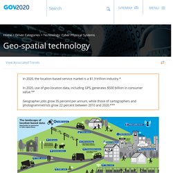
See: The power of zoom See: Beyond the bars See : Gov on the go Geospatial technology in 2020: *”Location Based Services – Market and Technology Outlook – 2013-2020,” Market Info Group LLC, **”Implications of the ICT Skills Gap for the Mobile Industry,” MacLeod Consulting, ***”$3.7 Billion Reasons Why GIS Technology is The Future,” American Sentinel University, Now let’s hear from you. Presentations (Provisional) Gemma BOIX XAMANI : SIGTE-Universitat de Girona (with Lluis VICENS FRANQUESA, Toni HERNANDEZ VALLÉS) INTRODUCTION This study of the things we can do using OpenStreetMap arises from SIGTE's need, as a service within the University of Girona, to offer the university community new cartographic services based on free data and, more specifically, on OpenStreetMap, from the elaboration of paper maps to computer applications like the publication of maps, the rendering of custom layers, routing, etc.
In this article we will examine the possibilities offered by OpenStreetMap and the main tools allowing one to operate with this data. AVAILABLE DATA AND DOWNLOADING There are three types of files ready to be downloaded. - planet.osm. This file, which takes up about 26 Gb in compressed format (pbf), contains all the OpenStreetMap mapping for the entire planet and is generated weekly. - history.osm. About Us - PlaceILive.com. Place I Live is a unique project which seeks to present all living environment and life quality-related information in one place.

We collect open data, crowdsoursed data and social media information and present it for our users in the most comprehensive way. After having entered his or her present (or future) address or post code in the search field, each user of PlaceILive.com finds himself or herself in the profile of a house where the most important information is provided. The information we supply includes transport information (petrol stations and transport stops, the most active streets), criminal data (number, types of committed crimes, locations of police headquarters), air pollution, noise level and the nearest medical institutions, the main demographic information (the average age, family status of the residents, etc.), the nearest entertainment, sports and leisure places, schools, stores, laundries and other places needed in everyday life.
MapInfo AnySite for Site Selection of retail, hotel, restaurant locations. AGS Base Demographics AnySite Online's Base System with AGS demographics includes the following database tabulations.
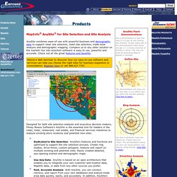
Current-year estimates, and Five and Ten-year projections can be supplied for the following tabulations, unless specified otherwise. The Base System demographic database is supplied by AGS which utilizes household level data from Experian's Performance Data System as an integral component in the updating process. Population: Population by Age Population by Age by Sex Race Hispanic Origin Population by Household Type Occupation Employment by Industry Labor Force Education Marital Status Ancestry Group Quarters Presence of Children by Household Type Households: Household Income Household Income by Age of Householder Family Income Tenure Household Type Persons per Household Housing Value Rent Units In Structure By Tenure Year Structure Built Year Moved Into Unit By Tenure Household Language AGS Premium Database Descriptions.
Cool Map THing : Curbed SF. Location Analytics Market by Software & Applications Expected to Reach $11.84 Billion by 2019 - New Report by MarketsandMarkets. October 29, 2014 -- (PRWEB) October 29, 2014 The report Location Analytics Market - Worldwide Market Forecast (2014 - 2019) defines and segments the location analytics market into various sub-segments with an in-depth analysis and forecasting of revenues.
It also identifies the drivers and restraints for this market with the insights on trends, opportunities, and challenges. Browse 71 market data Tables and 24 Figures spread through 176 Pages and in-depth TOC on Location Analytics Market - Worldwide Market Forecast (2014 - 2019) Early buyers will receive 10% customization on this report. Speak to Analyst @ Location analytics is the next revolution of business intelligence. Exclusive access to nationwide mobility data for traffic planning. Search best communities for business. Spend Analysis, Spend and Contract Visibility.