
Australia The Radiation Network is potentially global, and we now have some Monitoring Stations reporting intermittently from Australia, and an intermittent station from neighboring Bali, in Indonesia. = Nuclear Site Alert Level = 3 consecutive minutes of lesser of 100 CPM or 2.5 times a Station's baseline *Readings not Equalized means the Monitoring Stations are broadcasting the raw radiation count from their Geiger counters, without adjustment for different count rates existing between various Geiger counter designs.
Shock: Fracking Used to Inject Nuclear Waste Underground for Decades Aaron Dykes and Melissa MeltonActivist Post Unearthed articles from the 1960s detail how nuclear waste was buried beneath the Earth’s surface by Halliburton & Co. for decades as a means of disposing the by-products of post-World War II atomic energy production. Fracking is already a controversial practice on its face; allowing U.S. industries to inject slurries of toxic, potentially carcinogenic compounds deep beneath the planet’s surface — as a means of “see no evil” waste disposal — already sounds ridiculous, dangerous, and stupid anyway without even going into further detail. Europe Our network currently has a few Monitoring Stations in Europe. Keep your eye open for Yellow circles in Iceland, the Netherlands, Spain, Italy, and some intermittent stations reporting from Switzerland and Germany. = Nuclear Site Alert Level = 3 consecutive minutes of lesser of 100 CPM or 2.5 times a Station's baseline *Readings not Equalized means the Monitoring Stations are broadcasting the raw radiation count from their Geiger counters, without adjustment for different count rates existing between various Geiger counter designs. For instance, models built around a "Pancake" (see Map Legend) style of Geiger-Mueller tube typically have a 3 times count rate over Standard tubed models. Back to the Radiation Network
More Fukushima Deaths: ''Leukemia-linked Disorder'' Killing Baby Seals Along California Coast By Melissa Dykes While officials continue to tell us everything is fine, and they essentially act like the Pacific Ocean is a Mr. Clean Magic Eraser for all the radiated water being continuously dumped into it from the crippled Fukushima Daiichi Nuclear Power Plant, we are getting reports of baby seals dying of cancer off the coast of California.
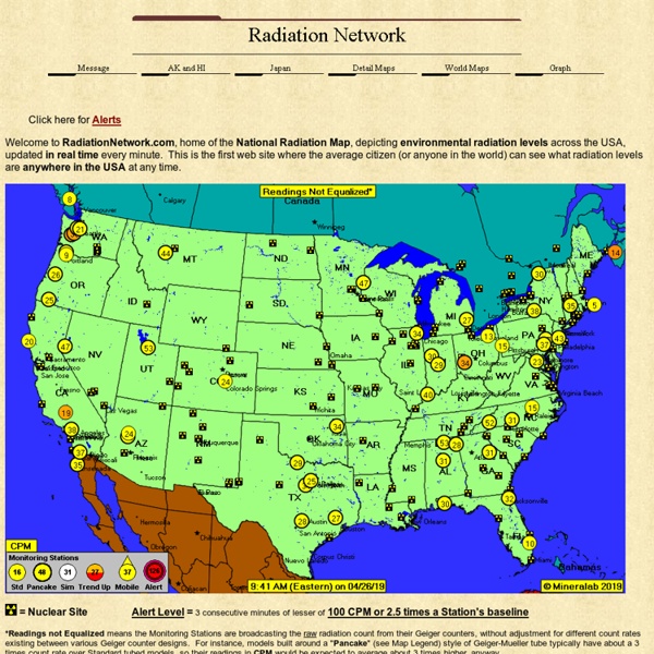
Detail Maps This page is devoted to detailed maps for regions of particular interest. Many have asked that overlapping stations be "spread apart", so this is how we are doing that. = Nuclear Site Alert Level = 3 consecutive minutes of lesser of 100 CPM or 2.5 times a Station's baseline *Readings not Equalized means the Monitoring Stations are broadcasting the raw radiation count from their Geiger counters, without adjustment for different count rates existing between various Geiger counter designs. For instance, models built around a "Pancake" (see Map Legend) style of Geiger-Mueller tube typically have a 3 times count rate over Standard tubed models.
Radioactive cesium-137 from Fukushima now detected off coast of Canada (NaturalNews) The first radioactive material from the 2011 Fukushima nuclear disaster has now been detected in the coastal waters of North America, according to a study conducted by researchers from Woods Hole Oceanographic Institution. "Radioactivity can be dangerous, and we should be carefully monitoring the oceans after what is certainly the largest accidental release of radioactive contaminants to the oceans in history," researcher Ken Buesseler said. In March 2011, a massive earthquake and tsunami caused three separate nuclear meltdowns at Japans' Fukushima Daiichi nuclear power plant. The explosion ejected massive amounts of radioactive material into the air, much of which ended up in the Pacific Ocean. Findings "expected" Among the radioactive elements released during the Fukushima disaster were cesium-134 and cesium-137, both of which occur on earth only as a result of human activity.
Access to clean water and sanitation around the world – mapped Around the world, 946 million people still go to the toilet outside. Eritrea is top of the list, with 77% of its population practising open defecation, a practice which can lead to the contamination of drinking water sources, and the spread of diseases such as cholera, diarrhoea, dysentry, hepatitis A and typhoid. A huge global effort has been focused on reducing these numbers and new data from the WHO/Unicef Joint Monitoring Programme, which has measured the progress made on access to drinking water and sanitation since 1990, shows that there have been improvements in certain areas. Eritrea’s neighbour Ethiopia has achieved the largest decrease in the proportion of the population practising open defecation, from 92% in 1990 to 29% in 2015. “Ethiopia has made a concerted effort to reduce open defecation rates over the past five years,” says Tim Brewer, Wateraid’s policy analyst on monitoring and accountability.
Government Contractor Buried Nuclear Waste Near St. Louis Playground By Joshua Krause Last month we all heard about the trash fire that threatens to ignite a radioactive waste dump in St. Louis, but apparently that isn’t the only nuclear dump site in the area. There is another site just outside of the city, and this one is located in the worst place imaginable. A cancer cluster has recently been discovered near a playground, where a government contractor dumped tens of thousands of radioactive waste barrels decades ago. CBS News has interviewed many of the residents that lived and played in the area as kids, and found that a shocking number of them have all come down with cancer.
Fire Atlas - Global Fire Emissions Database Latest revision: April 24th, 2019 Contact details: Niels Andela (niels.andela@nasa.gov). "The Global Fire Atlas of individual fire size, duration, speed and direction" Andela et al. (2019) The Global Fire Atlas is a new freely available global dataset that tracks the daily dynamics of individual fires to determine the timing and location of ignitions, fire size and duration, and daily expansion, fire line length, speed, and direction of spread. Data are available in easily accessible GIS-layers and can also be explored online here and a detailed description of the underlying methodology is provided by Andela et al. (2019).
Fukushima’s Political Fallout Puts Anti-nuke Researcher On Trial By Yoichi Shimatsu Dana Durnford, a former commercial diver who plies a rubber dinghy along the Canadian Pacific coast to study the effects of Fukushima radiation on marine life, has been arrested for making alleged death threats against a chemistry professor at University of Victoria in British Columbia. Mr. Durnford is facing trial on two counts of harassment related to his comments on video at his webpage, the Nuclear Proctologist. Coronavirus 2019-nCoV Lancet Inf Dis Article: Here. Mobile Version: Here. Data sources: Full list. Downloadable database: GitHub, Feature Layer. Lead by JHU CSSE.