
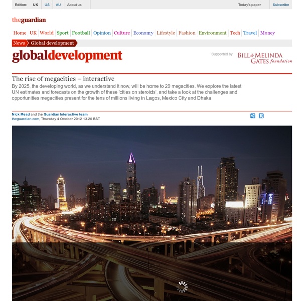
http://www.theguardian.com/global-development/interactive/2012/oct/04/rise-of-megacities-interactive
Related: C2: Des villes inégalement connectées aux réseaux de la mondiali • Carto • 4èmeHow We Share the World This interactive graphic shows how the world is divided according to six different socioeconomic variables. The land area of each country represents its share of the worldwide total. Click on a circle to reshape the map For attribution and data sources, scroll to the bottom. I have been having fun experimenting with cartograms lately. Education Available languages — Using OpenStreetMap in an Educational Context For information about academic research related to OpenStreetMap, see Research. For a general article about how to map educational facilities in OpenStreetMap, see Education features. Students learning about OpenStreetMap at a workshop at FEATI University in the Philippines OpenStreetMap is being used in schools, universities and colleges in a wide range of disciplines.
Virtual Issue on Latin American Cities Published Date: 25 Jul 2012 Picture above: Demolition of Favela Villa Nova Jaguaré and new housing development, São Paolo (photo by Yuri Kazepov, 2009); Pictures from left to right: Junction of Av. Vinte and Três de Maio, São Paolo and Downtown, Rio (photos by Yuri Kazepov, 2009); One of several deterioriated 1970s tower blocks in the Soldati neighborhood of Buenos Aires (photo by Ryan Centner, 2006) Virtual Issue Over the past ten years IJURR has sought to expand its coverage of Latin America cities, developing a critical urban scholarship that does not simply apply North American or European urban and regional theory to the region, but rather views Latin American cities on their own terms and uses their experiences to contribute to a more thoroughly global understanding of urban and regional phenomena.
Trans Atlantic Slave Trade What happens when a historian of slavery teams up with a computer scientist? A stunning visualization of the transatlantic slave trade. Professor Adam Rothman, a historian of slavery at Georgetown University, and Matt Burdumy (GU ’15), a talented computer science major, joined forces in Professor Rothman’s History of the Atlantic World class to map more than 35,000 slaving voyages from 1500 to 1870. Under Rothman’s guidance, Burdumy used his skills as a programmer to geolocate data from the Transatlantic Slave Trade Database, and layer the data as a time-lapsed heatmap on a Google Map canvas. Cities of the future In September 2012, the American review Foreign Policy published a special issue on Chinese cities. Ever since the 2010 World Exhibition in Shanghai, the international audience has shown an ever increasing interest in urbanisation issues in China, and several reviews have focused on this topic. The special issue of Foreign Policy can be seen as a response to a recent report published by the McKinsey Global Institute on the 75 most dynamic cities of 2025.
Les dix meilleurs cartes de la ville de New york en 2015 Despite spending an inordinate amount of time each day looking at maps, it is beyond me to select a list of the best maps from among everything posted last year on the web. There are far too many, more than I could ever hope to find, for the list to have any real meaning. Sticking to what I know best, I have compiled my favorite maps of 2015 that cover New York City.
The Agas Map Our new (as of the beginning of 2015) implementation of the Agas Map is based on the OpenLayers 3.0 library. It presents the map as a zoomable, rotatable tiled image with several hundred locations plotted on it. In the default view, the locations are initially hidden; you can show them by checking checkboxes in the navigation panel which appears at the top right of the map. Locations in the navigation panel are sorted into categories; click on a category name to expand it and see all the locations.
Talkin' 'bout the Ghetto: Popular Culture and Urban Imaginaries of Immobility Published Date: 05 Sep 2012 Image above: Rivke Jaffe (DJ Sunshine) and Azinta Plantenga (DJ Rudegyal), Leiden, The Netherlands (photo by Faline Plantenga) Black Widow soundsystem, Red Light, Jamaica, 2003 and Stone Love soundsystem, Kingston, Jamaica, 2010 (photos by Rivke Jaffe) by Rivke Jaffe This article by Rivke Jaffe is free to read. The author will be participating in an upcoming debate, in our debates and developments section, on Street Music, Urban Ethnography, and Ghettoized Communities.