
San Francisco, métropole inégale. Los Angeles, la métropole californienne aux mille visages. Los Angeles n’est pas une ville traditionnelle, avec un centre et une banlieue, mais plutôt un regroupement de quartiers qui ont tous une identité propre.
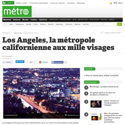
La grande variété ethnique de L.A. compte d’ailleurs parmi les facettes qui rendent cette ville plus intéressante, plus authentique et plus raffinée que son image superficielle le laisse souvent croire. New York City At Night - Aerial Photos of New York City. There's something about New York City and the way it pulses.
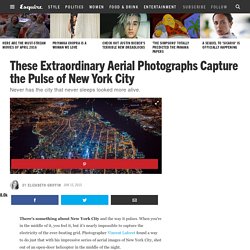
When you're in the middle of it, you feel it, but it's nearly impossible to capture the electricity of the ever-beating grid. Photographer Vincent Laforet found a way to do just that with his impressive series of aerial images of New York City, shot out of an open-door helicopter in the middle of the night. As Laforet said on his blog: This was an incredible adventure—and to be honest—self-imposed. Redefining Global Cities. The world’s largest metropolitan areas concentrate the drivers of global prosperity, but there isn’t one way to be a global city—this report defines seven types of global cities, providing a valuable lens through which to understand an evolving global economy. As societies and economies around the world have urbanized, they have upended the classic notion of a global city.
No longer is the global economy driven by a select few major financial centers like New York, London, and Tokyo. 13 Great Cities Then and Now. Lessons from the World’s Largest Megacity If a product says “Made in China,” chances are that product, or parts of it, came from the Pearl River Delta.
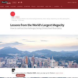
This region in southern China is the world’s largest megacity: eight major urbanized zones with a combined population of 55 million people, spread in a horseshoe-shaped ring around a complex watershed ecosystem. Hong Kong, Shenzhen, and Guangzhou dominate the region, which, incorporating five other emerging cities, has experienced explosive growth over the past 30 years. By studying the Pearl River Delta, we can better understand the challenges ahead as the world’s population becomes increasingly dense and urbanized.
The region has risen on the back of China’s meteoric manufacturing sector, which produces many of the household and retail commodities sold throughout the world. In the Pearl River Delta, we can see, writ large, the issues that many urban areas across the globe are currently — or will soon be — facing. Cartographie. Les villes prennent le pouvoir. Les mégalopoles sont les nouveaux moteurs de l’économie mondiale.
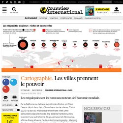
De la Californie au delta de la rivière des Perles, en Chine, l’avenir s’écrit dans des pôles urbains tentaculaires. D’ici à 2025, il y aura au moins quarante de ces villes ultra-connectées dans le monde. Los Angeles. How Hyperconnected Cities Are Taking Over the World, According to Parag Khanna. “Political geography is not determinant anymore, because cities are more important.”
In the medieval period, empires battled and colluded with each other in the quest for land. The resulting system, in which nations became the main actors on the global stage, is perhaps the one most of us know best. But it’s changing. We’re now moving toward a new era where insular, political boundaries are no longer as relevant. More and more people are identifying as “global citizens,” and that’s because we’re all more connected than we’ve ever been before. “Geography is destiny,” one of the famous adages about the world, is becoming obsolete.
Territoires Md° : dodo internet et inégalités accès mondiale. Scientists track Internet usage as it pulses across the globe daily Contact: Robert Perkins at (213) 740-9226 or perkinsr@usc.edu Researchers studying how big the Internet is have found that it “sleeps,” almost like a living creature.
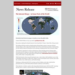
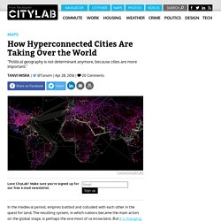
The finding will help scientists and policymakers develop better systems to measure and track Internet outages, such as those that struck the New York area after Hurricane Sandy. Understanding how the Internet sleeps will help them avoid confusing a sleeping Internet with an Internet outage. Territoires de la Md° en 38 Cartes- inégal intégration Md. Territoire Md° : inégal intégration -carte Device connectés. Carte mondial des tweets. Sur la carte mondiale des tweets, on repère les gares, les aéroports, les aires d’autoroute…
Dans quels lieux publics tweete-t-on le plus souvent ?
Croquis : Une inégale intégration des territoires dans la mondialisation. Deux croquis destinés tout particulièrement aux classes de Terminale.

Nighttime city maps – Les cartes nocturnes des villes. The rise of megacities – interactive. Points de repères : Les villes globales. On trouve des villes globales sur tous les continents, sous toutes les latitudes, de New York à Buenos Aires, de Londres à Mumbay, de Tokyo à Sydney.
Tant en termes de création de richesse que de pilotage de l’économie mondiale, quelques pôles urbains tiennent cependant le haut du pavé. La mégalopole américaine, le réseau de villes européen et le nuage urbain Tokyo-Osaka se voient confirmés dans leurs fonctions. Une poignée de villes émergentes asiatiques s’est néanmoins imposée, emmenée par Singapour, Séoul et Hong Kong. Il existe plusieurs manières de mesurer l’importance économique d’une ville.
Les Villes dans la mondialisation [carte] B02c_FT500_2010.jpg (Image JPEG, 510x648 pixels) - Redimensionnée (95. B04c_Bourses_fin_2009.jpg (Image JPEG, 681x782 pixels) - Redimensionnée (79. Une cartographie du réseau physique de l'internet mondial. Ca fait un moment que l'on nous bassine avec le "Cloud", mais si les smartphones nous font croire qu'internet vient des nuages, dans la réalité c'est une immense toile de câbles (ce n'est pas pour rien qu'on appelle ça le "Web") qui parcourent toute notre jolie planète.

Cartographie. Les villes prennent le pouvoir. Mégacités. A l’avenir, les villes auront le pouvoir, pas les pays. Les 50 premiers aéroports intercontinentaux et internationaux - Monde. Les villes globales dans l’économie mondiale. Ville-réseaux, ville « liquide » Le 27 octobre, en partenarait avec gpmetropole.fr, EDF organisait la troisième session de son cycle intitulé « Grand Paris Histoires et Futurs ».
Nous vous proposons d’en retrouver ici les principaux échanges. Deuxième temps : les réseaux numériques. Tweetping. Les dix meilleurs cartes de la ville de New york en 2015. Despite spending an inordinate amount of time each day looking at maps, it is beyond me to select a list of the best maps from among everything posted last year on the web. There are far too many, more than I could ever hope to find, for the list to have any real meaning.
Sticking to what I know best, I have compiled my favorite maps of 2015 that cover New York City. Because of its density and diversity of people and culture, its high availability of public data, and its large tech community, New York makes for some outstanding maps. With all the great work that has been done, this list could really be many times larger. How We Share the World.
This interactive graphic shows how the world is divided according to six different socioeconomic variables. The land area of each country represents its share of the worldwide total. Six billion tweets.