
What is the difference between raster and vector data? Raster and vector are two very different but common data formats used to store geospatial data.
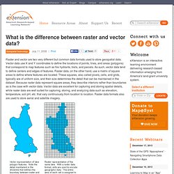
Vector data use X and Y coordinates to define the locations of points, lines, and areas (polygons) that correspond to map features such as fire hydrants, trails, and parcels. As such, vector data tend to define centers and edges of features. Understanding Map Projections.pdf (application/pdf Object) 2 - Raster Interpolation toolset sample applications. Large scale and small scale. About Map Projection-What is a Map Projection? This article consists of six parts matter that are; References Knippers, R.A. (1998).
Coordinate systems and Map projections. Introduction to GIS.