
Home. QGIS 2.0 Wkshop. Kansas Data Access and Support Center - Your resource for geospatial data from the State of Kansas. Online Master of Science in Geographic Information Science and Technology. GIS Courses & Tutorials. Aeronautics and Astronautics AA 272C.
Global Positioning Systems — The principles of satellite navigation using GPS. Positioning techniques using code tracking, single and dual frequency, carrier aiding, and use of differential GPS for improved accuracy and integrity. Use of differential carrier techniques for attitude determination and precision position determination.
Prerequisite: familiarity with matrix algebra and MatLab (or another mathematical programming language). 3 units, Winter 2010–2011 school year Anthropology ANTHRO 98B/298B. Civil and Environmental Engineering. GIS Distance Learning - Certificate and Degree Programs. Don’t have a school near you offering GIS?
If you don’t live near a college or university offering GIS coursework, distance learning can be a valuable way to learn GIS skills and software programs online. Find schools offering GIS distance learning coursework via internet-based classes in the field for certificate and degree-based programs. The program descriptions listed here have been supplied by the colleges and universities.
GIS Distance Learning Programs American Sentinel University American Sentinel has provided Geographic Information Systems related degree programs since 2007. Delta State UniversityDelta State University offers a Master degree program, Master of Applied Science in Geospatial Information Technologies (MAS-GIT). Elmhurst College The Online Geographic Information Systems (GIS) Certificate Program at Elmhurst College will prepare you to succeed in the exciting geospatial technologies industry.
GIScOnline Distance Learning courses from Birkbeck College, London. 17 Free GIS ESRI Courses [Professional Certifications] Certification Program Overview. GISCorps - Home. Six Things You Should be Doing to Enhance Your GIS Career. GIS is not a static field and neither should your ongoing professional development be.
With more and more academic institutions offering GIS certificate and degree-based programs, the competition in the field for GIS jobs is growing. 1. Continue a Habit of Lifelong Education Take advantage of the range of training and learning opportunities available. As your budget allows, take advantage of online and in-person training sessions. Read! Learn what your peers have to say about the geospatial field. Geospatial Freelance - Home. ArcGIS tutorials. This topic provides a set of links to a collection of various ArcGIS tutorials used to perform a number of common tasks in ArcGIS.
Find the tutorial that you would like to work through by clicking the links in the tables below. To work through the ArcGIS for Desktop tutorials, you need to install the tutorial data from the ArcGIS for Desktop Tutorial Data setup, which is part of the ArcGIS for Desktop installation download or media. If the tutorial data has been installed on your system, look for it in C:\arcgis\ArcTutor (the default installation location). In many cases, you will need write access to that location to perform the tutorial. The ArcGIS for Server installation does not include tutorial data. Keep in mind that these tutorials are only a starting point for you to learn about ArcGIS. Resources. Global Biodiversity Information Facility. GIS Data Warehouses. Information about web sites that host large amounts of GIS datasets both at the nationwide (United States) and global levels.
Most of the GIS data is available for free or for little cost. Data.gov Data depository for U.S. government data with over 272,000 datasets. The site also has an Apps Showcase, highlighting different sites that are using data from Data.gov. EROS Data Center The USGS EROS Data Center houses millions of aerial photographs of the United States, as well as images from several series of satellites covering the entire Earth. Federal Communications Commission Datasets Mostly MapInfo format vector datasets available for free download.
MapMart Commercial data service. National Atlas National Atlas of the United States has nationwide datasets to view and download as ArcView shapefiles. Principles of Geographic Information Systems PDF. GIS Tutorials and Training. Training. Learn GIS for Free. Ad: There are a few online options to learn GIS for free.
Take advantage of resources that provide you access to free courses from some of the world’s best universities and institutions. GIS Basics. How GIS Works - The Query A query is the same thing as a search.
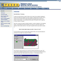
When you do a query, you are asking a database to find all of the data that is related to the terms, phrases, or features that you choose. This is similar to how an internet search engine finds specific web pages when you type in the phrase "mountain bikes", or a computerized library system finds specific books, magazines, or authors related to "bluejays". With GIS, you query the system by asking a question, or series of questions, to the database system. It then displays the data that relates to your query as a new theme. Which Surface Water Intakes are within .5 miles of a river? As we saw earlier, we have the Surface Water Supplies, Rivers, and County Boundaries all combined into one digital map using GIS software. The next step is using the Query tool to choose the specific data features you want. The GIS then displays the data which matches your query, or your search criteria. GIS Tutorials and Exercises.