Zoom
Trash

GIS Guru - Student Projects in GIS Portfolios? - GeoPivot. GIS Certification: Is It Worth It? GIS certification Last Modified: Mar 14, 2015 You might have asked what are the different GIS certifications that are available today.
On top of that, is it really worth the time, money and effort to be GIS certified. GIS Certification versus Certificate Programs ~ GIS Lounge. GIS certification and certificate programs are two similarly named yet different markers of a person’s GIS education and skills achievements.

To sort out the confusion, both certificate programs and GIS certification are described in this article. GIS Certificate Programs GIS certificate programs are usually a series of GIS related coursework provided by an educational institute. A higher degree (such a a bachelors or masters) is not awarded at the completion of the coursework. GISjobs.com - The Most Popular GIS Jobs Website - Offering jobs listings, resumes, salary survey, GIS resources, and more! Salary.com Salary Wizard- Do you know what you're worth? Prepare to Get That Job: 20 Challenging GIS Interview Questions. In 2004, Directions Magazine published an article called the Top 15 Interview Questions.
They were generic questions any hiring manager might ask. Eight years later we want to update those with questions that are more specific to the field and go beyond button-pushing. Editor in Chief Joe Francica, Executive Editor Adena Schutzberg and principal of ENTCHEV.com, Atanas Entchev, compiled the questions they might ask of candidates. We’ve not separated them out for more or less technical positions or entry level or advanced ones; we feel most are applicable to the full range of positions.
Skills. Preparing for a GIS Job Interview ~ GIS Lounge. Having sat on both sides of the table, I know that the interview process can sometimes be an uncomfortable and even painful process.
To make matters more difficult, the GIS field requires a broad range of skills ranging from cartographic techniques to programming to relational database management. Acquiring enough depth in any of these areas can seem impossible especially when the field is still evolving at a horrendous pace. So what is it that’s really important when it comes to interviewing for a GIS position? The Resume As with all positions being applied for, your resume is the initial introduction you have for a prospective employer. Ten Tips to Prepare for a GIS Job Interview ~ GIS Lounge. Interviewing for a position in the GIS field is not that much different from interviewing in other fields )see the article How to Survive the Interview Process for landing the interview).

Kristina Jacob presents 10 tips to get you thinking about how you will prepare yourself for that interview. 1. Volunteer If you are hoping to interview for a paid internship or entry level position, try doing some volunteer work. While some companies and/or organizations might not have the budget for a paid internship, they might have the space for a volunteer position. Introduction to ASPRS Certification Program. Accredited Programs. Programs are accredited by CESB in one of four categories.
The categories are based on the prerequisites candidates for certification must possess and CESB Accreditation Guidelines. Professional Engineering Programs. Overview of Esri Technical Certification. GISCI > Home. GISjobs.com - The Most Popular GIS Jobs Website - Offering jobs listings, resumes, salary survey, GIS resources, and more! The GIS Jobs Clearinghouse. Industries. Online GIS Magazines and News Sites. These online geospatial magazines will help keep you up-to-date on the new tools, tips and tricks of the trade.
Many have informative articles as well as industry news. ArcNews Online Online version of ArcNews. Dedicated to users of Esri products, mainly its ArcGIS suite of GIS software. Contains case studies and news about Esri products. ArcUser Online ArcUser magazine contains tutorials, productivity tips, and articles on new technology, technology integration, GIS industry applications, and user articles mostly focused on ArcGIS. Esri Regional and Local User Groups. URISA - URISA. The Open Source Maps That Make Rescues in Nepal Possible. Since a massive 7.8 magnitude earthquake struck Nepal on April 25, over 7,000 people have died, and many more have been injured or left stranded in rural areas.
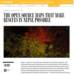
Aid groups like the Red Cross and Doctors Without Borders have deployed teams to help those left behind in the districts of Dhading, Gorkha, Rasuwa and Sindhupalchowk. But there are plenty of people who are contributing from thousands of miles away—on their lunch break, after work, or on the weekend. They’re part of an online community of volunteers from all over the world who are mapping Nepal from their laptops, creating data that’s critical to on-the-ground relief.
More than 4,000 mappers—part of OpenStreetMap (OSM), the biggest crowd-sourced mapping project on the Internet—joined in the effort. Within 48 hours, they had mapped out 13,199 new miles of road and 110,681 buildings, quadrupling the road mileage covered and adding 30 percent more buildings. Click to Open Overlay Gallery.
OpenStreetMap Foundation Wiki. GEOLOGY ARCGIS SPECIALIST. Specialist ArcGIS Course applied to Geology and Mining - Online Training This course will qualify students in ArcGIS Desktop 10.x and, in particular, in ArcMap, ArcCatalog and ArcToolBox, for the development of projects related to geology, hydrogeology and mining.
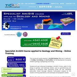
Students will gain advanced knowledge in ArcGIS 10 tools, useful for the design of geologic and hydrologic studies, such as georeferencing and digitizing of geological maps, generating DTMs, 3D cuts, estimating piezometric levels, drainage networks, multivariable analysis for the location of mining exploitations, and landscape and topographic studies. Studying the online course, students have access to our virtual learning platform (available 24 hours) where they will find the course contents, exercises, discussion forums and additional content. 10 Free GIS Data Sources: Best Global Raster and Vector Datasets - GIS Geography. In a perfect world, you’d be able to find all the free GIS data you need in a single website. Of course, it would have to be free, downloadable from an authoritative source. …But well, you know the drill. The world’s not perfect, life’s not fair.
So that’s why we’ve put together this list to turbo-charge your search for free GIS data. We provide a list of 10 free, downloadable global GIS datasets from highly reputable sources. Spatial Data Quality: An Introduction ~ GIS Lounge. Data quality is the degree of data excellency that satisfy the given objective.
In other words, completeness of attributes in order to achieve the given task can be termed as Data Quality. Production of data by private sector as well as by various mapping agencies assesses the data quality standards in order to produce better results. Data created from different channels with different techniques can have discrepancies in terms of resolution, orientation and displacements. Data quality is a pillar in any GIS implementation and application as reliable data are indispensable to allow the user obtaining meaningful results.
Spatial Data quality can be categorized into Data completeness, Data Precision, Data accuracy and Data Consistency. Topology Overlay. The Topology Overlay dialog creates a results drawing from two other drawings using Identity, Intersect, Union and Update overlay functions. These functions may also be performed by a sequence of transform toolbar operators. The Topology Overlay tool provides one-step functionality to make it easy to perform these common functions. Overlays simultaneously create new objects in the results drawing and also populate data columns as necessary. Overlay functions are also referred to simply as overlays. All overlays require two drawings: a data drawing that may contain areas, lines and points and an overlay drawing that must contain areas. ArcGIS Help 10.1 - Buffer (Analysis) Illustration Usage If buffering a projected feature class that has features covering a large region, or you are using a very large buffer distance, distortions in the projection can cause inaccurate buffers to be produced.
You can completely avoid distortion when buffering by using a feature class that has a geographic coordinate system and specifying a Buffer Distance in linear units (meters, feet, and so forth, as opposed to angular units such as degrees). When this combination of inputs is used, the tool will generate true geodesic buffers that accurately represent distances on Earth's surface. Geodesic buffers may appear unusual on a flat map, but when displayed on a globe these buffers will look correct (you can use the ArcGlobe or ArcGIS Explorer applications to view geographic data on a three-dimensional globe).
ArcGIS Desktop. GIS Manual: Raster GIS Tutorial (Libraries) Analytic Techniques This tutorial introduces several useful patterns for using raster GIS data and procedures. In previous tutorials we have looked at the language of relational data models and the extension of these to incorporate vector data types and operators that evelauate spatial associations between entities reprented as rows in tables. We have noted that the representational vocabulary of vector relational GIS is categorical in nature. The entities represented are singular and discrete. We have also looked at raster / cell-based data like the terrain models we downloaded from the U.S. Sample Dataset. ModelBuilder. Python Syntax.
Python Syntax. What is geoprocessing? Geoprocessing is for everyone that uses ArcGIS. Whether you're a new or advanced user, geoprocessing is likely an essential part of your day-to-day work with ArcGIS. The fundamental purpose of geoprocessing is to provide tools and a framework for performing analysis and managing your geographic data. The modeling and analysis capabilities geoprocessing provides make ArcGIS a complete geographic information system. Geoprocessing provides a large suite of tools for performing GIS tasks that range from simple buffers and polygon overlays to complex regression analysis and image classification. The kinds of tasks to be automated can be mundane—for example, to wrangle herds of data from one format to another. For Developers. For Developers. Python Syntax.
For Beginners. Welcome! Are you completely new to programming? If not then we presume you will be looking for information about why and how to get started with Python. Fortunately an experienced programmer in any programming language (whatever it may be) can pick up Python very quickly. Python. For Developers. ArcGIS Help 10.1 - What is geoprocessing? ArcGIS Help 10.1 - What is editing? Introduction to editing. MOOC Lab Rubrics. Coordinate system. Geodesy and the Earth's Size and Shape. Earth, with average distance of 92,955,820 miles (149,597,890 km) from the sun, is the third planet and one of the most unique planets in the solar system. It formed around 4.5-4.6 billion years ago and is the only planet known to sustain life. This is because factors like its atmospheric composition and physical properties such as the presence of water over 70.8% of the planet allow life to thrive.
Geodetic datum. A Geodetic datum or geodetic system is a coordinate system, and a set of reference points, used to locate places on the Earth (or similar objects). What is a Map Projection? Submit Your Vote for GeoLounge! Map Projections: Azimuthal Projections. Map Projections: Conic Projections. <br /><table class="warning" summary=""><tr><td><h2 class="warning">JavaScript Is Not Available</h2><table summary=""><tr><td><img src="../.. /StockImg/warning36.png" alt=""></td><td> </td><td><em>Since JavaScript is disabled or not supported in your browser, some or all maps in this page will not be displayed. Map Projections: Cylindrical Projections. OSI SAF ASCAT-A 12.5-km product. How to Add XY Data in ArcGIS.
ArcGIS Help 10.2 - Welcome to the ArcGIS Help Library. GIS Data Explored - Vector and Raster Data. The Difference Between Raster and Vector Data. Spatial database. ArcGIS Help 10.1 - A quick tour of the geodatabase. Spatial relationships by feature type. ArcGIS Help 10.1 - Spatial relationships by feature type. ArcGIS Help 10.1 - Building a query expression. History of cartography. Scale of measurement. Cartographic Design. Evaluate ArcGIS Online for Organizations. What is GIS. Understanding GIS. A - GIS Dictionary. Comparison of geographic information systems software. GISCorps - Home. OIE World Animal Health Information System. Quality Matters Program. University of West Florida.