GIS
> Robgeog
> Geography
Getting Started with Survey123. ArcGIS. Quantitative methods in the GIS and mapping industry - Rob Sharpe (Esri UK)
Your Location for Lifelong Learning. Welcome to Esri Training We build and deliver ArcGIS Platform training for hundreds of thousands of users each year.

We believe that knowledgeable individuals can accomplish great things in their organizations and communities by applying geography to solve problems. Enjoy your journey, we’re here to help. Authoritative Resources. Esri Videos. What is GIS. GIS in Geography – Lessons from the 2016 ESRI UK Conference. GIS is an exciting area of geography offering the opportunity for incredible interactive resources to enthuse students and teachers.
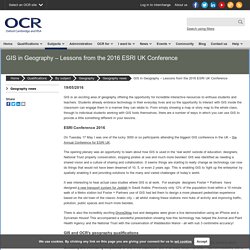
Students already embrace technology in their everyday lives and so the opportunity to interact with GIS inside the classroom can engage them in a manner they can relate to. From simply showing a map or story map to the whole class, through to individual students working with GIS tools themselves, there are a number of ways in which you can use GIS to provide a little something different in your lessons.
ESRI Conference 2016 On Tuesday 17 May I was one of the lucky 3000 or so participants attending the biggest GIS conference in the UK – the Annual Conference for ESRI UK. The opening plenary was an opportunity to learn about how GIS is used in the ‘real world’ outside of education: designers, National Trust property conservation, stopping pirates at sea and much more besides!
Maps.stamen.com / terrain beta.
Login. GIS and CAD exercises. MapStream for Schools. Data Sources Archives - GIS Geography. How to Download Sentinel Satellite Data for Free - GIS Geography. Download Sentinel-1 and Sentinel-2 Satellite Data If you want to download Sentinel satellite data, then you’ve come to the right place.
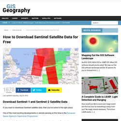
One of the most exciting developments in remote sensing at this time is the European Space Agency’s Copernicus Programme. Copernicus’ six Sentinel satellites collects comprehensive pictures of our land, ocean, emergency response, atmosphere, security and climate change to understand the health of our planet. Until very recently, this data has become available to the public at no cost Today, we show you step-by-step how to download Sentinel satellite data:
I Can See for Miles and Miles. Home - GIS Geography. Understanding GIS. Story Maps. Download Free eBook 01 - GIS University. The ArcGIS Imagery Book: A Geographic Rosetta Stone. Imagery is Visible Intelligence By: Dave Grenley The next generation of imagery intelligence comes alive in The ArcGIS Imagery Book: New View.
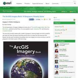
New Vision., published by Esri Press. It is now available in print, interactive PDF, and interactive companion website. The new book provides readers with a wealth of gorgeous, inspiring images and links to powerful web apps and maps that weave interesting stories about our planet and the issues we face. The ArcGIS Imagery Book offers a look back at the fascinating history and rapid evolution of earth observation technology. Additionally, readers will gain hands-on experience working with powerful imagery and remote-sensing data through the book’s companion lesson plan from the Learn ArcGIS organization. The book’s editors, Clint Brown, Esri director of software products, and Christian Harder, Esri senior editor and writer, said they hope the book will help turn readers into “GIS and imagery aces.” The Map of the Future is an Intelligent Image. GIS Education Community.
Geography summer camp?
I will be offering an exciting 5-week online course beginning 25 May 2016 entitled Teaching Geography for the 21st Century. You can register here.
Digimap For Schools. Ecoexplorer.arcgis. The Uprooted. Creating flow line maps in ArcGIS Online. Choropleth mapping with the 2015 Index of Multiple Deprivation in ArcGIS Online. Understanding contours in 2D and 3D (based around Helvellyn)
An introduction to quantitative and cartographic skills for fieldwork using ArcGIS Online.
2015 Index of Multiple Deprivation. Esri, HERE, DeLorme, NGA, USGS | Esri, HERE | Zoom to Legend Layers LegendOpacity050100LegendOpacity050100 Basemap gallery.

Global elevation. StreetLight Data. OpenDataSoft — Home. CDRC Maps. Visual comparison of the most and least deprived areas. Teaching the Census through GIS. Main.
Digimaps
Overview - GIS for Schools. Understanding GIS (The GIS Files), our guide to using map data. GIS software for schools. Below is some information on the available GI software packages for schools.
The brief comments about each item need to be followed up by looking at the complete descriptions of each product on the associated web sites. Some of these packages come with pre-loaded data, others accept Ordnance Survey data. Pleae note that we are not responsible for the content of third-party websites. This GIS from the The Advisory Unit, Computers in Education, is ideal for projects: urban land use (Goad plans, vector OS MasterMap);traffic and pedestrian flows;choropleth census and development mapping;andlocational charts. OS raster and vector map subscription. Visit AEGIS Soft Teach - Local studies 5 An introduction to GIS for Key Stage 2, Local Studies now has a Map Grabber, which means that you can use Ordnance Survey maps as backgrounds for projects on your town, back garden or school grounds! Visit Soft Teach uLearn. GIS Zone. GIS in Geography Teaching and Learning. Introduction GIS is an exciting development in geography education because it brings an expanding area of new technologies into the classroom and fieldwork.
GIS is already part of everyday life in satellite navigation systems, it powers market research linked to supermarket card schemes, delivers government information online and aids the emergency services.
