
Creating flow line maps in ArcGIS Online. Understanding contours in 2D and 3D (based around Helvellyn) An introduction to quantitative and cartographic skills for fieldwork using ArcGIS Online. Using ArcGIS for AS fieldwork. You are going to use a website called ArcGIS.com to create a map to first show the places where your data collection took place and eventually to present some of your data.
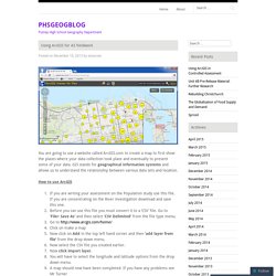
GIS stands for geographical information systems and allows us to understand the relationship between various data sets and location. How to use ArcGIS If you are writing your assessment on the Population study use this file. If you are concentrating on the River investigation download and save this one.Before you can use this file you must convert it to a ‘CSV’ file. Go to ‘File> Save As’ and then select ‘CSV Delimited’ from the file type menu.Go to on make a mapNow click on Add in the top left hand corner and then ‘add layer from file’ from the drop down menu.Now select the CSV file you created earlier.Now click import layer.You will have to select the longitude and latitude options from the drop down menu.A map should now have been completed.
Data Presentation Follow these steps. Like this: Like Loading... How to make a killer map using Excel in under 5 minutes with PowerMap plugin. Many times it happens that you need to quickly visualize your data on a map but you don’t have a time to play for hours with ArcGIS or QGIS to make it look good.
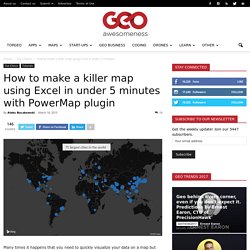
In this tutorial I’ll show you how make an awesome looking map in Excel in under 5 minutes with a free plugin called PowerMap (formerly GeoFlow). 1. Download and install the plugin. Of course the first step would be to download and install the plugin from Microsoft website. You should download it and install without any issues. Initially the plugin was restricted only for MS Office 365 subscribers and owners of an expensive MS Office Professional Plus suite but recently it has been released for all MS Excel 2013 users.
If you don’t see it you might need to activate it in Add-Ins menu. In the dropdown list on the bottom of the window select COM Add-ins and click GO. Now everything should work fine. 2. Now its time to prepare your data. Geocoding will allow me to show a phenomena on a map based on a city or a country name. 3. 4. » New! ArcGIS Online support for schools David Holmes – Geography Education. Digimap for Schools. Esri - GIS Mapping Software, Solutions, Services, Map Apps, and Data. Educators - GIS for Schools. Geographic information systems can help learners of all ages understand the world around them.

GIS helps students and educators engage in studies that promote critical thinking, integrated learning, and multiple intelligences at any grade. In classrooms around the world, educators are using GIS to study geography, earth science, history, math, language arts, and more. Students can engage in important career and technical education (CTE) at the same time that they build a background in science, technology, engineering, and mathematics (STEM) fields. Service learning and field-based research activities help students be active in their communities and address local problems large and small.
Find out more about activities and resources for students. Introductory Materials These documents explore the incorporation of GIS and geographic concepts in the classroom: GIS in Action Read case studies that show how educators use GIS as a tool for academic instruction. Overview - GIS for Schools. Fieldw_sd_article.pdf. Esri ArcGIS. GIS GSCE Fieldwork Case Study: The Urban Structure of Bishop's Stortford Peter O'Connor, Head of Geography at Bishop's Stortford College, has written a highly adaptable, step-by-step guide to setting up a fieldwork case study based on the urban structure of Bishop's Stortford.
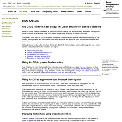
The project uses the Esri ArcGIS software, and Peter guides the reader through the process of setting up the project, getting started with the software, and using analytical and graphical tools to produce impressive land use maps. Although based on the urban structure of Bishop's Stortford, the techniques addressed through the case study can be easily adapted to other locations and topics. Free GIS and maps for fieldwork. Written by David Holmes, Geography Advisor to the Field Studies Council and Senior Examiner for Edexcel Download the full Supporting high quality fieldwork using free maps and GIS from the internet article (PDF) What is GIS?
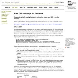
A geographical information system (GIS) has the ability to store, retrieve, manipulate and analyse a range of spatially related data. With a GIS the user may ask questions of data related to the map, search for patterns and distributions and investigate the underlying relationships between different sets of data.GIS handles data quickly and efficiently, proving mapping facilities that may have taken many hours to complete manually. Digital resources and new mapping technology must represent the cornerstone of support for fieldwork at the beginning of the 21st century. Digital resources from the internet deliver a number of advantages in the context of fieldwork: The basic maps sites Another excellent map resource is Multimap (now Bing Maps).
Figure two: Digital map.