
Earth-measuring Software. QuestMX Estimating is now ProContractorMX Estimating Looking for a powerful earth-measuring program that also provides an unparalleled level of accuracy?

Maxwell Systems' core earth-measuring program offers unique features designed to help you complete your jobs fast. Examples include the ability to cut and fill with greater ease, instantaneous access to key site information, enhanced takeoff capabilities and innovative trench features, to name just a few. What's more, our verification features can help ensure you get the job right each and every time. Increase Profitability with QuestMX With the increased estimating speed provided by QuestMX earth-measuring software, you’ll be able to submit more bids and win more projects.
Learn More about Maxwell Systems Earth-Measuring Solutions Maxwell Systems offers a variety of earth-measuring solutions to meet the needs of all types of construction operations: 7902-geospatially-white-paper.pdf. What is Map Intelligence? Integeo’s Map Intelligence merges the location dimension into enterprise decision support and Business Intelligence applications.
Map Intelligence is a fast, highly configurable and efficient platform for delivering customised, map-enabled business applications involving BI tools and mapping providers and GIS. Is location as a BI dimension new to you? Map Intelligence is being used by Government Senators, front desk operations staff, decision makers, business analysts and non-IT report designers. For those of you using sophisticated Business Intelligence tools, Map Intelligence has a rich arsenal of spatial tools tightly integrated into your familiar BI environment.
Map Intelligence is designed for dynamic use in a web-browser with or without BI integration. Key Business Benefits of Map Intelligence. Underground coal mine delay data analysis system - viewcontent.cgi. InSight News @ AGSI 2010 V6 I6. Burlington Hydro Inc.
(BHI) an electric distribution utility with over 64,000 customers has implemented AGSI's Intelligent Network™ solution, the world's first Smart Grid ready and operational utility geospatial solution. The initial BHI AGSI Intelligent Network™ implementation included deployment of an, open architecture, asset management and geospatial environment providing an enterprise-wide source of unified corporate information, all in real-time. The secure, web-based, Intelligent Network applications deployed at Burlington Hydro are built on AGSI's GO360 platform and include: Design and Engineering, including AGSI's SpatialNET Power; Secure Permission based Enterprise Viewing; Mobile and Infield computing; On-line editing via the web; Asset Query, Analysis, Display, Reporting and Updating/Management; Operational Interfaces; Integration to Asset Management, CIS, and Financials (including billing); and Executive Dashboards, Reporting and KPI's.
Enabling Geospatial Business Intelligence. “About eighty percent of all data stored in corporate databases has a spatial component.”
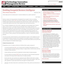
Carl Franklin Recently, interest in the huge potential of Geospatial BI has increased. It aims at combining geographic information system (GIS) and business intelligence (BI) technologies. Geospatial BI combines spatial analysis and map visualization with proven BI tools in order to better support the corporate data analysis process and to help companies make more informed decisions. BI is a business management term which refers to applications and technologies that are used to gather, provide access to, and analyze data and information about company operations. This article provides a rapid introduction to some important BI concepts. A Rapid Introduction to BI BI applications rely on a complex architecture of software that is usually composed of: Figure 1 illustrates the typical infrastructure on which BI applications rely. Case Study: Geospatial Dashboard software, Realtime mapping interface, Geofencing, fleet management. Projects » Geospatial Dashboard Company profile The client is a Colorado-based technology company specializing in online tracking solutions for the transportation industry.
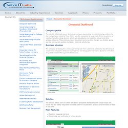
They offer a way for companies to keep track of their assets via a variety of small tracking devices, which operate globally over satellite, cellular and other wireless networks. These devices report movement and any other changes you dictate, giving you not only current position, but also a historical activity log. Business situation The company is looking for a new ways to improve their customers' satisfaction by delivering a new level of integration between Analytics Tool and Geographic Information Systems in the form of spatially enabled Management Dashboards. Solution The solution allows users to utilize web based geospatial dashboards with Google maps and charts that are tightly integrated to enable powerful visualization, analysis and simulation of data in real-time. Main Features Technologies. Suite Dashboard. Www.geokettle.org. GeoKettle: A powerful open source spatial ETL tool. Business analytics and business intelligence leaders.
Business analytics and business intelligence leaders.