
GIS Timeline ~ GIS Lounge. The early beginnings of GIS occurred in Canada in the 1960s.
Boundless : Introduction to PostGIS. Information Geographies. QGIS v ArcGIS - xyHt. Okay, so I’m likely to get lynched, but before all the lovers/haters come out of the woodwork I’d like to remind everyone that these two systems are both great achievements.
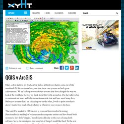
We are looking at two software systems that have changed the way we look at the world and the way we think about the world around us. The have allowed us to communicate issues and information in near real time and have saved many lives. Before you assume that I am criticizing one or the other, I wish to point out that it doesn’t matter too much which is better as whichever one you use is the best. 3. Getting Started [Documentation Center] This Getting Started guide describes how to: Load an existing data transformation Create a new data transformation 3.1 Start Spatialytics ETL Start Spatialytics ETL from the start menu in your operating system or from the command line as explained in the Installation section Please wait, the application will take a few moments to start up You will be prompted with the following dialog.
![3. Getting Started [Documentation Center]](http://cdn.pearltrees.com/s/pic/th/getting-started-documentation-102955090)
Fill in the repository information or simply click the “No repository” button to enter the Spatialytics ETL’s workbench. Geospatial Technology and the Future of the City — ArcNews by Esri. By Jack Dangermond, Esri President A few months ago I was asked by the City of Los Angeles to share a few technology trends about the future of GIS in cities and how these enabling trends would make cities smarter.
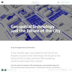
Over the past four decades, GIS technology has systematically impacted local government by improving basic record keeping and data management as well as automating a wide variety of geospatially-related workflows including mapping. Oslandia. The latest PostGIS and QGIS 3D enhancements presented at FOSS4G by Oslandia are available online.
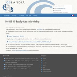
We suggest you to have a look on our PostGIS 3D / QGIS 3D video demonstration using SFCGAL library and the QGIS Horao plugin : A step by step workshop, (really close to the video workflow) is also available online : We can provide you the full virtual machine on demand, with proper software environment (6GB Virtual Box Image). Guide to the Role of Standards in Geospatial Information Management.
Geospatial information comes from many different sources and is managed by many different providers from mapping agencies to commercial data providers to volunteered geographic information.
To optimize usage of this data there is a need to easily discover and share this information. Standards are essential to enable the sharing of authoritative geospatial data and services and provide significant value to society and government inlcuding enabling global competitiveness of both industry and nations. Guide to the Role of Standards in Geospatial Information Management. WIRED : In the '60s, models floated... European Union Open Data Portal. GeoPackage Encoding Standard. 1) Overview 2) Downloads 3) Related News.
Online GIS - Meet The Cloud Publication Platforms That Will Revolutionize Our Industry » Videos » Social GIS Professional Networking Community. Login ID: Password: Forgot your password? Sign Up GeoMeeting Social Networking Community helps you connect and share with the people in your life. OpenCellID - OpenCellID. Elephant Appeal: What do elephants do all day? - IV Drip - Voices. Just like us humans, they eat, sleep, socialise and roam about.
The charity Space for Giants fits elephants in Laikipia, Central Kenya, with GPS collars to monitor their movements, providing a real-time window into their daily lives. Together with a new mobile phone app, scouts on the ground can keep track of where elephants are going. SIG'ArT (sigart) - accueil. Vous aussi, vous pouvez publier votre plus beau bug ou votre plus beau traitement géomatique sur SIG'ArT !
Un article pour la section "Et aussi... " à proposer ? Un mail est également le bienvenu ! Open is an adjective and a verb. Baguala project is testing new methods to analyze and compare the evolution of National Spatial Data Infrastructures. During the SAGEO meeting held in Brest (France) from 23 to 26 september, 2013, members of the Baguala project presented methodological solutions to analyze how the contents of Spatial Data Infrastructures of France, Brazil and Bolivia are currently evolving.
The future developments of these methodes are expected to allow more accurate and data-based interpretations of the political role of these new and original public institutions specialized in information management. Access to the short paper which describes the methodological path. Cartographic design home. Cartography in the digital age - Arts, Design, Editor's Picks. Jazzberry Blue Anthony Robinson grew up navigating the family vacation via a fold-up map in the back seat of the car. His daughter, not quite two, has been born into a different world. “She’ll never have a concept of having to go and ask someone for directions,” says Robinson, who is a geographer. GPS tracking, satellite navigators and digital maps that fit in your pocket have freed us from needing to ask, “How do I get there?” And yet map production, and consumption, is booming. GeoMeetup (San Francisco, CA. Welcome! We are a group of developers, enthusiasts and users interested in the technical aspect of different geo technologies.
This group is meant to be an open, friendly, technical forum where you can find answers to your geospatial questions or learn more about Geographic Information Systems (GIS). A cool geo-project: If you ever had "traditional" questions like/about: - What is the best way of storing the locations for my mobile app? Or if your interests include less traditional questions related to: Maps and Games in Dresden (Germany) – August 25th 2013.
A Workshop + A Playground gaming session convened by the Maps and Society + the Arts and Cartography Commissions of the International Cartographic Association Game Studies emerged as a discipline in parallel with the growth of videogaming in the 1980s (see Salen and Zimmerman 2004) and by 2012 the gaming industry had a global turnover of around US$65 billion. Maps play a very significant role in many different game genres. From puzzles, to shoot-em-ups, to mazes, quests, sport sims, strategy-based war-games, urban games and geo-caching, mapping represents a largely unquestioned backdrop, but often also delivers a central and active role in game play.
Stat spatiale. GoGeo - The portal to spatial data and information. Tutorials. Web Mapping General D3: Data Driven Documents. D3 is a javascript data visualization library made for modern web browsers. It introduces data into dynamically created SVG canvas elements. While D3 can be used for many information graphics, this series focuses on D3.Geo, which is the geographic component of the library. Introduction & Setup – Establish your D3 environment on your local computer for testing and creating your products before pushing them live.TopojsonBasemapProjectionsTopojson InteractionQueue.jsLabelsProportional Symbols Leaflet.
Video of Goodchild Lecture – GANS at Dalhousie June 4th, 2013. <p>JavaScript required to play <a hreflang="en" type="video/mp4" href=" Goodchild Lecture June 4th, 2013; Dalhousie University With thanks to Dr. GIS Doctor. La carte n'est pas le territoire, mais elle le sert. Bretagne— Un haut lieu de la cartographie à l'extrémité de la Bretagne. Land Management - Land Management. Summer of Maps - Summer of Maps - Azavea's summer fellowship program for student GIS analysts and nonprofits. Geodesign: A Bibliography.
La cartographie augmentée. Publications and conferences - Cartonomics: Space, Web and Society » Cartonomics: Space, Web and Society. Le petit blog cartographique.
Opendata. Geographic Information Systems (GIS), Web Mapping, and GPS. Google. Cool TED Talk: "Making sense of maps" Home / GIScience / Cool TED Talk: “Making sense of maps” – Dublin Public Transportation Map Graphic designer Aris Venetikidis is talking about his idea of making great transportation maps based on human natural cognitive mapping. He observed that when we visualise an area such as a city centre, we do not see an accurate reflection of the geographical realities.
OSM. Indoor mapping. From geovisualisation to neocartography: Maps in a digital world. Space & time. GeoWeb.