
Earth - Your life on earth. Explore BBC Earth's unique interactive, personalised just to you. Find out how, since the date of your birth, your life has progressed; including how many times your heart has beaten, and how far you have travelled through space. 1280 × 1103 - rsta.royalsocietypublishing.org 433 × 403 - web.ics.purdue.edu 500 × 350 - en.wikipedia.org 398 × 328 - solarsystem.nasa.gov.
MC 30 SEC RIM TOUR 864 486. MeteorCrater-1min-ProRes. 500 × 235 - skepticalscience.com.
Teaching the Rock Cycle on Pinterest. The 17 Most Amazingly Epic Places on Earth Do the usual cities and beaches leave you a bit... underwhelmed?
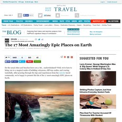
Well, we're here to bring you to a magical realm of bubbling volcanoes, cliff-top castles, and roaring waterfalls. After pouring through the tips and experiences from the minube travel community, we're happy to present this list of the 17 most amazingly EPIC places on Earth. 1.) Playa de las Catedrales, Spain - Nothing says epic like the roaring surf and giant arches of the famous Playa de las Catedrales in Galicia, Spain. It's breathtaking to view from above, but during low tide you can head down and explore the winding tunnels and caves of this stunning rock cathedral. Journey to the Centre of the Earth. Climates of the world - Climate Zone. Journey to the Centre of the Earth. JOindex. This site describes a field trip through a section of oceanic plate (crust and uppermost mantle) that is exposed on the western edge of the North American continent.
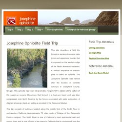
A vertical sequence of oceanic plate is called an ophiolite. Fs2011-3024. San Joaquin Valley Geology. Geology of the San Joaquin Valley. There are several aspects to the geology of the San Joaquin Valley.
The story begins here with the Geologic History. Links to the other chapters of this story are on the menu to the left. Geologic History The San Joaquin Valley is a sediment-filled depression, called a basin, that is bound to the west by the California Coast Ranges, and to the east by the Sierra Nevadas. It is classified as a forearc basin, which basically means that it is a basin that formed in front of a mountain range. Fault creep along the Calaveras in Hollister, California. Introduction Hollister, California is located South of the San Francisco Bay area.
(Here is a regional map courtesy of Xerox PARC.) Make a Barometer. We have looked at air pressure with eggs before.
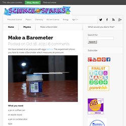
This experiment shows you how to make a Barometer which measures air pressure. What you need: a jar or coffee can an elastic band a pin or cocktail stick. Journey to the Centre of the Earth. Photographer Captures Manhattan Sized Glacial Quake As The Ice Splits From Its Shelf. Geological Society of America - Educator Resources. Introduction to Physical Geology. <hr><p><b>You must have javascript enabled to view this website.
Please change your browser preferences to enable javascript, and reload this page. </b></p><hr> Introduction to Physical Geology Geology uses the scientific method to explain natural aspects of the Earth - for example, how mountains form or why oil resources are concentrated in some rocks and not in others. This chapter briefly explains how and why Earth's surface, and its interior, are constantly changing. Expanded Readings From Chapter 1. Educational mobile apps for Geology and the Earth Sciences - Tasa Graphic Arts, Inc. The Mineral Database app provides a quick reference of mineral data for students, educators, professionals, or anyone interested in minerals.
This searchable database is easy to use. No internet connection is required. Geology and Earth Sciences - Download free content from UC Davis. Geology Videos. Earth Revealed. Due to licensing agreements, online viewing of the videos for this resource is restricted to network connections in the United States and Canada. 1.
Down to Earth Surface conditions of the planets Venus and Mars are compared with those of Earth, and scenes of Earth's living landscapes lead into a discussion of how unique Earth truly is. Major topics addressed in the series, including plate tectonics, natural resources, seismology, and erosion, are introduced in this program. Colorado Geologic Map. Colorado has parts of the Great Plains, the Colorado Plateau and the Rocky Mountains within its four border lines. (more below) Created by Andrew Alden from the U.S. Geological Survey's Geologic Map of the United States, 1974, by Philip King and Helen Beikman (fair use policy) Click the map for a larger version. CGSHome. Geos 112 Intro Geology - NJCU. Gem and Mineral Shows Across America and the World! Event Calendar for shows where minerals and gems are sold!
Gem & Mineral Shows and Events Mineral Shows are happening all across the world, even around YOUR TOWN! Welcome - Minerals Education Coalition. Detailed mineral report for Stumbling Stud Mine (Badito Cone Mine), Gardner Area, Huerfano Co., Colorado, USA. Badito-cone, 37105g1 from USGS 24K Maps - COLORADO - East View Geospatial. From Topographic Maps Series USGS 24K Maps - COLORADO Published By United States Geological Survey Visit our Online Store to browse and buy today.
Shop Now Options / Pricing Samples / Proofs More samples from this series are available upon request. Questions? Contact Us Live Chat. CGSHome. Southern Rockies Geology. The ancient basement rocks of southern Colorado were formed during Proterozoic orogenies, mostly in the middle Proterozoic, 1.0 to 1.8 billion years ago. A great variety of granites and metamorphic rocks make up the Proterozoic crust. These rocks have been uplifted to form the cores of many ranges of the Rocky Mountains, including the Culebra Range of the Sangre de Cristo Mountains. The erosional resistance of the these crystalline rocks supports the high peaks. The period from late Proterozoic through middle Paleozoic was a time of stable continental conditions in which various sedimentary strata were deposited in shallow seas and low-lying land environments. Limestone, dolostone, sandstone, and shale mark this interval. Beginning in the Pennsylvanian, a significant change took place in Colorado tectonics.
Volcanic Plugs, Buttes and Cones. Nearby Attractions - Capulin Volcano National Monument. GC1M14N What's So Tuff About Rhyolite? (Earthcache) in Colorado, United States created by jp66 and ernie66. About 36 million years ago, there was a catastophic volcanic eruption near Mt. Princeton in the Collegiate Range, about 100 miles to the west. The eruption created a superheated cloud of pumice, ash, and rock that traveled to this area within about an hour. As it landed, it melted together under its own weight and formed a welded tuff, a glassy rock that has become known as the Castle Rock Rhyolite or Wall Mountain Tuff. List of volcanoes in the United States. List of volcanoes in the United States. A list of volcanoes in United States of America and its territories. Central Colorado volcanic field. The central Colorado volcanic field is a volcanic field in Colorado, USA. The Geologic Time Scale. America's Volcanic Past - Colorado. Pagosa Springs Geology. There are five geological requirements for a hot spring.
Oldoinyo Lengai, World's Weirdest Volcano. Volcanic Plugs, Buttes and Cones. Arches National Park in Moab, Utah - My Photos. SNOWMASTODON™ - Snowmass Village, CO - WELCOME! The Snowmastodon Project™ : Denver Museum of Nature & Science. COLORADO GEOLOGY.
GeologyLink® - Virtual Classroom. The Geological Society of America. New USGS North Cascades Geologic map « Northwest Geology Field Trips. Nam.html. Virtual Field Trips. Arches geology field trip. The California Geotour...Online Geologic Field Trip Guides. Field Trips. Geologic Time Page. History of Underseacable. Geology Adventures - Geology Adventures. Geology and mining industries of the Cripple Creek district, Colorado. Dictionary - Diatomite, Drawdown, Drumlin.
Resources For Earth Sciences and Geography Instruction - Central Michigan University. Geology of National Parks. Paleogeography. Exhibits Collection. The Rock Cycle . Introduction. Dynamic Earth . Intro. Geologic Formations of Utah: Navajo Sandstone.
Gasland/Fracking.