
Rare first edition of ‘The Map that Changed the World’ unearthed #map #science #geology. ¿Cómo afecta el deshielo de la Antártida a la gravedad de la Tierra? El satélite Grace de la NASA y el de la Agencia Espacial Europea, el GOCE, han proporcionado durante años alarmantes datos sobre ambos procesos.
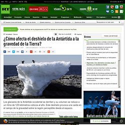
Y entre 2009 y 2012 un colectivo de científicos del Instituto Alemán de Investigación Geodésica, la Universidad Técnica de Múnich (Alemania), la Universidad Tecnológica de Delft (Países Bajos) y el Laboratorio de Propulsión a Chorro (Estados Unidos) estableció una correlación inmediata entre ellos. Para monitorear los efectos del cambio climático, la capa de hielo de la Antártida fue dividida convencionalmente en cuencas hidrográficas de distinto tamaño. A partir de esta matriz, las mediciones del Grace pudieron ser procesadas de manera comparativa para averiguar qué cambios sufren los glaciares en cada cuenca y cómo se produce la descarga de hielo a los océanos. En cifras absolutas la variación de la gravedad no es muy grande, asegura la revista 'Slate'. Este efecto se debe a la tensión del subsuelo. The Most Detailed Map of the Ocean Floor Ever Was Made From Space. Why Deadly Japan Volcano Erupted Without Warning. The death toll at Japan's Mount Ontake volcano climbed to 36 today (Sept. 29), with rescue crews still searching for missing people.
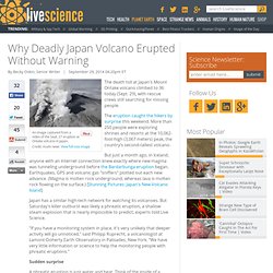
The eruption caught the hikers by surprise this weekend. More than 250 people were exploring shrines and resorts at the 10,062-foot-high (3,067 meters) peak, the country's second-tallest volcano. But just a month ago, in Iceland, anyone with an Internet connection knew exactly where new magma was tunneling underground before the Bardarbunga eruption began. Earthquakes, GPS and volcanic gas "sniffers" plotted out each new advance.
(Magma is molten rock underground, whereas lava is molten rock flowing on the surface.) Water scientists. Becky is a hydrogeologist who has specialised in groundwater modelling and is working in Sydney, Australia.
She was born in England but moved to the other-side of the world to further her career. The types of models that Becky works with are called “numerical groundwater models”, which are computer based simulations of real-life groundwater systems. These can be used to predict impacts to groundwater systems, such as whether changes to one system (such as coal seam gas wells removing groundwater from coal seams) might cause significant changes to the amount of groundwater that is available for a farmer at his or her groundwater well, for example. Groundwater modelling is based on a lot of maths and physics equations, but Becky uses a software program that makes it easy to input the data, so, even though she is pretty smart at maths, she doesn’t have to do a lot of number work. El Sahara se formó por la contracción del antiguo mar de Thetys hace 7 millones de años. La desecación de ese mar, precursor del Mediterráneo, debilitó la acción del monzón africano provocando la expansión de las condiciones de aridez del desierto.
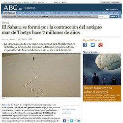
El Sahara se formó por la contracción del antiguo mar de Thetys hace 7 millones de años. Iceland Eruption, Largest for a Century, Shows No Signs of Stopping. The Bardarbunga eruptive fissure on September 1, 2014.

Credit: University of Iceland/Ármann Höskuldsson The largest lava eruption for over a century is currently underway in central Iceland. Model 3D de l'àrea volcànica de la Garrotxa - BETA PORTAL ICGC. L’evolució de la WEB està comportant noves maneres de visualitzar i interactuar amb la geoinformació.
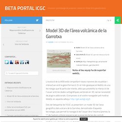
En el món geoespacial WebGL és una tecnologia que té particular interès, atès que possibilita la interacció de l’usuari amb les dades cartogràfiques vectorials en 3D, sense necessitat de plugins addicionals. (Comproveu si el vostre navegador pot mostrar WebGL en aquesta adreça: Des del betaportal de l’ICGC us presentem un model 3D de l’àrea geogràfica dels volcans de la Garrotxa, demostrador d’aquesta tecnologia, que permet la navegació de l’usuari dins l’escena (premeu la “i” de l’extrem inferior esquerra per a veure les tecles de control). On Twitter: "Iceland's Latest Volcanic Eruption Has Airlines Nervous. Here's Why #infographic #geology. Iceland's Latest Volcanic Eruption Has Airlines Nervous. Here's Why. (INFOGRAPHIC)
Iceland, home to one of the largest glaciers in Europe and a multitude of volcanoes, made headlines this week following news of a small eruption in the Bárðarbunga (or Bardarbunga) volcanic system.
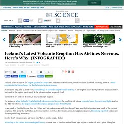
At 118 miles long and 15 miles wide, Bardarbunga is Iceland's largest volcanic system, so an eruption could have profound implications for air travel in the region, particularly if the volcano emits a large ash cloud. New Iceland Eruptions Visible From Space. Two new lava-spouting fissures opened overnight Thursday (Sept. 4) in Iceland, and NASA's Terra satellite spied the hotspots from space.
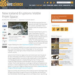
The lava erupted Sept. 5, just 1.2 miles (2 kilometers) north of Dyngjujokull glacier. Magma rose through cracks in the ground in a long depression called a rift valley. The valley appeared just a few days earlier, when the ground shifted to accommodate the fresh magma feeding the older Holuhraun eruption to the north. The Terra satellite's MODIS instrument captured the eruption at 12:50 p.m. local time (8:50 a.m. Mount St. Helens Is Recharging: What Rising Magma Means. ANCHORAGE, Alaska — Mount St.
Helens is nowhere near another eruption, but new magma is rising underground, heaving the volcano upward and outward by the length of a fingertip, researchers said here today (May 2) at the annual meeting of the Seismological Society of America. SGeology side effects puzzle astronauts #geology Strange Siberian Spikes Prompt Astronauts to Phone Home. Houston, we have a question: What are these weird spiky shapes we're seeing as we fly over Siberia?
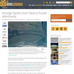
That's what astronauts were asking this June, when the sight of strange, dark-green features running along Siberia's Kulunda Steppe left them stumped, according to NASA's Earth Observatory. The curving features streak across the plain near the Ob River, and can be seen from the International Space Station (ISS) when it flies over the Northern Hemisphere's 52nd parallel, the highest latitude of its orbit. Fortunately for the ISS astronauts' burning curiosity, researchers at NASA Johnson Space Center in Houston had answers.
The spikes are a side effect of the geology of the region: Folded surface rocks (shaped by tectonic forces) dip lower than the surrounding land, creating long, linear valleys filled with pine forests. Humanity's Longest-Lasting Legacy: Miles of Holes. It's estimated that humans have altered over half of the planet's surface, and those changes are easy to see – the ice sheets are melting, forests are shrinking and species are going extinct. People have changed the planet so dramatically that some geologists think the Earth has entered a new phase in its geological timeline, named the "Anthropocene. " But what about the marks humans are leaving deep underground? "Because it's not in our immediate living environment, it doesn't seem as significant," said Jan Zalasiewicz, a senior lecturer in palaeobiology at the University of Leicester, in the United Kingdom. The Aftershocks — Matter.
Giulio Selvaggi was asleep when the shaking started. Long-lost continent found under the Indian Ocean. Jack Abuin/ZUMA Press/Corbis The beaches of Mauritius contain fragments of a type of rock typical of ancient continental crust — rock which could have been brought to the surface by volcanic eruptions. The drowned remnants of an ancient microcontinent may lie scattered beneath the waters between Madagascar and India, a new study suggests. Evidence for the long-lost land comes from Mauritius, a volcanic island about 900 kilometres east of Madagascar.
Methane-bubbles. Hundreds of Methane Plumes Erupting Along East Coast. Hundreds of Methane Plumes Erupting Along East Coast. Icelandic Volcano Rumbles Raises Eruption Fears. Earthquake swarms are shaking up a large ice-capped volcano in Iceland, raising worries of an eruption that could trigger flooding and send ash clouds into the atmosphere. The 2010 eruption of the Eyjafjallajökull volcano triggered floods and ash plumes that halted air travel to Europe. (Related: "Iceland Volcano Erupts Under Ice, Triggers Floods. ") Icelandic Volcano Rumbles Raises Eruption Fears. Instagram. Earth's Most Abundant, But Hidden Mineral Finally Seen, Named. Instagram. Instagram. If The Earth Stopped Spinning, Some Really Bad Things Would Happen. Scientists Get First Look Inside Mysterious Siberian Crater. Russian scientists got their first look inside the mysterious crater in Yamal, Siberia on Wednesday, July 16, while the Siberian Times took a helicopter ride to get another look down into the hole.
Based off of the original video of the crater, it was estimated that the crater could have been up to 80 meters wide. Nature's strongest glue comes unstuck. Over a 150 years since it was first described by Darwin, scientists are finally uncovering the secrets behind the super strength of barnacle glue. Still far better than anything we have been able to develop synthetically, barnacle glue – or cement - sticks to any surface, under any conditions.
But exactly how this superglue of superglues works has remained a mystery – until now. An international team of scientists led by Newcastle University, UK, and funded by the US Office of Naval Research, have shown for the first time that barnacle larvae release an oily droplet to clear the water from surfaces before sticking down using a phosphoprotein adhesive. Giant Hole Forms In Siberia, And Nobody Can Explain Why. A giant hole has opened up in Siberia, and nobody quite knows why. The massive hole, which spans about 262 feet in diameter, was spotted recently on the Yamal Peninsula in Russia, commonly known as the "end of the world," The Siberian Times reported. The depth of the hole is not yet known. Earth Had Oxygen Much Earlier Than Thought. Oxygen may have filled Earth's atmosphere hundreds of millions of years earlier than previously thought, suggesting that sunlight-dependent life akin to modern plants evolved very early in Earth's history, a new study finds.
Mud Volcano? Weird Island Appears After Pakistan Earthquake. Deep-Focus Earthquake Analogs Recorded at High Pressure and Temperature in the Laboratory. Why Earth's Inner and Outer Cores Rotate in Opposite Directions. Earth's Core Spins In Two Different Directions, Groundbreaking Research Reveals.