
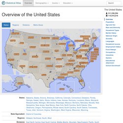
Rediscover the world as you've never seen it before. Track Planes In Real-Time. MarineTraffic: Global Ship Tracking Intelligence. Google Maps Streetview Player. Plotaroute.com - Walking, Running, Cycle Route Planner. Overview of the United States - Statistical Atlas. States:
Localingual: listen to the voices of the world. MapInSeconds.com by Darkhorse Analytics. Lonely Planet. GeoBeats - Guided video tours of your next international destination. Whichis.it — Which country is this? Play Statetris. Google Sightseeing — Discover the world via Google Maps and Google Earth.
Geography Resources - Geography Study - Learn Geography - Geography Facts - Geography Help - World Maps and Facts. Real time world statistics. GeographyIQ - World Atlas - Home Page. Globe Genie - Joe McMichael. Tag geography - Test Your Knowledge. Interactives archive: Exploration. Body BreakdownsClick on different parts of a climber's body to discover what people experience at high altitudes.
Climb DenaliExplore the demanding route from base camp to the 20,320-foot summit. Climb EverestFollow the routes up the north and south sides of Mount Everest, through 360° photographic panoramas and animation. Day In the Life, ALearn what it's like to be an astronaut aboard the Mir. Decode Stela 3"Read" Maya hieroglyphs carved on an eighth-century stone monument, and hear them spoken aloud. Desert FindsLocate the "Rub al Khali Desert" and try to figure out the best mechanism to navigate your way out. Escape from AntarcticaRelive Ernest Shackleton's fantastic voyage from Antarctica'a Elephant Island to South Georgia island using a sextant and a chart.
Explore the Methuselah GroveIn this series of breathtaking 360° panoramas, place yourself 10,000 feet up in California's White Mountains, where the world's oldest tree has stood for almost 5,000 years. Interactives archive: Earth. Amber Around the WorldFrom the Arctic to the tropics, from Mexico to Myanmar, amber is cosmopolitan, as this clickable map shows.
Anatomy of KatrinaTrack the hurricane from its birth in the open ocean through its catastrophic encounter with the Gulf Coast. Anatomy of NyiragongoFind out what features make this unquiet volcano tick. Anatomy of a TsunamiFollow the tsunami from its birth at the seafloor to its devastating collision with coasts around the Indian Ocean. Blasts From the PastExplore a clickable map of supereruptions around the world. Brief History of Life, AExplore the history of life on Earth as we know it today, from the earliest bacteria to the first modern humans.
Interactives archive: Disasters. Anatomy of KatrinaTrack the hurricane from its birth in the open ocean through its catastrophic encounter with the Gulf Coast.
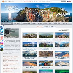
Anatomy of NyiragongoFind out what features make this unquiet volcano tick. Anatomy of a TsunamiFollow the tsunami from its birth at the seafloor to its devastating collision with coasts around the Indian Ocean. Asteroid That Hit L.A., TheA catastrophe calculator lets you try out some "what if" scenarios. Blasts From the PastExplore a clickable map of supereruptions around the world. How New Orleans FloodedExamine a visual chronology of exactly where and how 85 percent of the city wound up underwater. Map the FloodSee how much of your city would have been submerged. Once and Future TsunamisWith this interactive world map, learn about nine tsunamis, and see where the next one could strike. Let's describe the whole world! World Maps - geography online games. 3D Panoramas. Bromo volcano, Java, Indonesia Wayag Island, Raja Ampat, Indonesia Antarctic expedition of AirPano, Part I Volcano Klyuchevskaya Sopka, Kamchatka, Russia, 2015 Dubai, UAE Iceland, the best aerial panoramas New 7 Wonders of the World Petra, Jordan Great Wall of China Grand tour of Moscow, Russia Barcelona, Spain Everest, Himalayas, Nepal, Part II, December 2012 Santorini (Thira), Oia, Greece Plosky Tolbachik Volcano, Kamchatka, Russia, 2012 Iguazu Falls, Argentina-Brazil.
Earth wind map. 9 Excellent Free Map Creation Tools for Teachers and Students. 1- Umapper UMapper is a great mapping tool for educators.
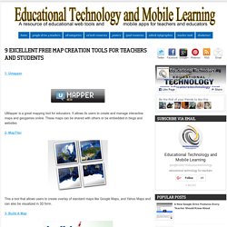
It allows its users to create and manage interactive maps and geogames online. These maps can be shared with others or be embedded in blogs and websites 2- MapTiler This a tool that allows users to create overlay of standard maps like Google Maps, and Yahoo Maps and can also be visualized in 3D form. 3- Build A Map This is another cool tool for teachers to create maps. 4- World Map This one here is being developed by Center for Geographic Analysis at Harvard University and allows users to easily build their own mapping portal and publish it to the world or to just a few collaborators.
Public Data Explorer. Earth album alpha - a slicker google maps + flickr mash-up. Teachers Homepage - National Geographic Education. This website would like to remind you: Your browser (Firefox 17) is out of date.
Update your browser for more security, comfort and the best experience on this site. Educators! Take our survey for a chance to win a $50 Amazon gift card. Xpeditions is now archived in National Geographic Education's new website—natgeoed.org If you liked Xpeditions, you'll love the new media-rich natgeoed.org. Www.natgeoed.org Please note: to search for Xpeditions content, check the “include archive” filter. National Geographic Education Twitter Facebook Google+ Email Quiz Connection! Most Popular Latest Videos.