
Turkey Map / Geography of Turkey / Map of Turkey. 1 | 2 Description (Page 1) The historic palette of Turkey is traced to the Stone Age settlements constructed in 7500 BC, and today, unforgettable names like Cyrus the Great, Homer, Alexander the Great, Troy and the Trojan War, the Holy Roman Empire and the Medieval Crusades leap from the pages of its ancient history.
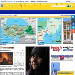
Many relics and ruins of same still stand for all to view. As for the Trojan War, there's some debate as to whether it was an actual historical reality, or whether just a story passed down. According to Greek mythology the Trojan War occurred in the 13th or 12th century BC after Paris of Troy took Helen from her husband, Menelaus, king of Sparta. MapZone. Geography is an interactive section of Mapzone designed by Ordnance Survey to help you with the map work you do at school and increase your mapping skills for leisure and fun.
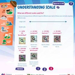
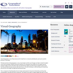
It's packed with information that you should find useful. From brushing up on your mapping skills to providing you with sample projects, Homework Help can assist you with all aspects of your mapping work at school and leisure. Our interactive activities and, animations all play their part to help you learn some important lessons about maps and how to use them. Visual Geography. Visual Geography is a set of base resources for PowerPoint or interactive whiteboards, and can be used for primary or secondary.
Games_and_stories.pdf. Primary Geography Handbook Extension Project - Maps and Stories (6-9) You are here : Home | Projects | Primary Ha... | Maps and S... | 6-9 This page extends the content of Primary Geography Handbook Chapter 21 Citizenship, PSHE and primary geography by Elaine Jackson (pp.289-299) '...There is a strong connection between primary geography, its content, teaching and learning strategies, and all aspects of children's lives and experiences.
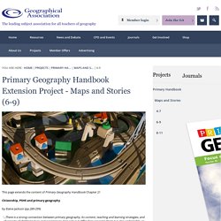
Not only is it difficult to separate them it is also undesirable, as real life does not come in compartmentalised boxes. Jackson (2004) p.289. Geoscience Australia Metadata for NATMAP Digital Maps 250K 2008 - Australia mosaic. PICTURE BOOKS - Mahara. Question_Matrix.pdf. Google Slides - create and edit presentations online, for free. How to Make and Use a Spear (Kriol) Uluru-Kata Tjuta National Park. Fs-flora.pdf.
Biodiversityteachersguide3.pdf. Interesting Facts About Mulga Acacia. Mulga acacia (Acacia aneura) is a fascinating tree with a long history of human use.
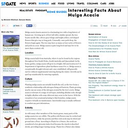
Growing up to 18 feet tall with a similar spread, the tree boasts needle-like, silvery gray foliage and bright yellow, rod-shaped flowers that give way to long pods. Unusually, once pods drop, the flowers begin again. The tree may have as many as four cycles of flowers and pods in a year. Mulga acacia is quite long lived and may live to be more than a century old. Location Mulga acacia hails from Australia, where it can be found in dry regions throughout New South Wales, South Australia and Queensland. Culture. DustEchoes-Spear-StudyGuide.pdf.
DustEchoes-Spear-StudyGuide.pdf. Using Artefacts in the Geography classroom. 1301.0 - Year Book Australia, 2006. Among the extreme environmental conditions experienced by plants and animals in Australia's deserts are aridity, heat and salinity.
Plants and animals have evolved a range of morphological, behavioural and physiological adaptations to enable persistence and reproduction in desert environments. Australia's vegetation - Australian Plant Information. There have been various attempts to devise a classification to accommodate the distinctive vegetation of Australia.
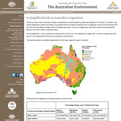
The system most widely recognised at present was drawn up by Specht (1970) and defines structural forms of vegetation in terms of the dominant plant form and the percentage of foliage cover of the tallest plant layer. The use of foliage cover rather than canopy cover takes special account of the open nature of eucalypt crowns. In this classification, a tree is defined as a woody plant more than 5 m tall, usually with a single stem. A shrub is a woody plant less than 8 m tall, frequently with many stems arising at or near the base. The map below gives a simplified representation of the major vegetation types in Australia. Structural forms of vegetation in Australia (based on Specht 1970) Part3.pdf. Fire Book. You are not authorized to view this page. The Web server you are attempting to reach has a list of IP addresses that are not allowed to access the Web site, and the IP address of your browsing computer is on this list.

Please try the following: Contact the Web site administrator if you believe you should be able to view this directory or page. Technical Information (for support personnel) Go to Microsoft Product Support Services and perform a title search for the words HTTP and 403.Open IIS Help, which is accessible in IIS Manager (inetmgr), and search for topics titled About Security, Limiting Access by IP Address, IP Address Access Restrictions, and About Custom Error Messages. The Web server you are attempting to reach has a list of IP addresses that are not allowed to access the Web site, and the IP address of your browsing computer is on this list.
Please try the following: Contact the Web site administrator if you believe you should be able to view this directory or page. Crook Hat and Camphoo (2005) clip 1 on ASO. Clip description Elders Crook Hat and Camphoo are walking through the bush searching for the right tree to make spears.
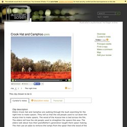
They tell us that the old people used to cut down the Acacia tree to make spears. Speaking Land. Atlas of South Australia. The Archaeological Record The Aboriginal occupation of Australia exceeds 1200 human generations compared with a maximum of 8 generations of European occupation.
During its long course of human history the Australian continental area has fluctuated significantly as global sea-levels adjusted to the advance and retreat of the polar ice caps. During the last glacial period, when much of the world's ocean water was locked up in ice and the coastline was considerably further seaward, Tasmania and Kangaroo Island were linked with the mainland, and Torres Strait was narrower. The initial human landfall in Australia seems to have been achieved by small numbers of seafaring people who arrived along the northern coasts.
Over time, climatic shifts provided more favourable conditions for Aboriginal hunter-gatherers over Australia, and local populations increased. Austn-indigenous-tools-and-technology. Geography of a Pencil - National Geographic Education. 1. Discuss the component parts of a pencil. Distribute pencils to students. Ask: What materials or natural resources do you think make up a pencil?
Organize student ideas on the board.