
The digital journalist’s toolbox: mapping. Engaging and interactive journalism is still possible even without an extensive knowledge of coding.
But how? We’ve taken the guesswork out, scouring the internet to find the most accessible tools to create multimedia content. Below, you’ll find a collection of completely free applications that will do all the work for you — no coding required: Google My Maps: This tool is probably the most familiar, simply because it mimics maps seen on a phone’s GPS.
StoryMapJS. The True Size Of ... F4map. Free Map Tools. StoryMapJS. HOT Export Tool. OER World Map. MapsWithMe), detailed offline maps of the World for iPhone, iPad, iPod, Android, Amazon Kindle Fire and BlackBerry. Esri Partners with Waze Connected Citizens Program to Deliver Unprecedented Open Data-Sharing Option. Global smart-mapping leader Esri today announced a new partnership with Waze, the free, crowdsourced traffic and navigation app that makes it easier for governments of every size, anywhere in the world, to begin building intelligent transportation systems in their communities.
Governments already using the Esri ArcGIS platform can quickly and easily exchange data through the Waze Connected Citizens Program, a free, two-way data share of publicly available traffic information. Taking Maps in a New Direction. Apps bridge people to the things they want and the places they want to find via their phone, tablet, or PC quickly and effortlessly.
Consumers specifically, use apps for their most basic needs and desires; checking the weather, listening to music, scoping out deals, finding new venues, and of course communicating with friends. With this information readily available, consumers have a more intimate, connected and relevant experience with your business. Bing Maps allows your application to: Quickly visualize data on a map—such as geographic coordinates, employee distribution and retail locations. Information and Mapping in the Public Interest. Green Infrastructure for the U.S. MapHub · Create interactive maps.
Welcome to the OGC. Esri Launches National Green Infrastructure Initiative for Planning. Esri, the world leader in geographic information system (GIS) technology, has launched a suite of public mapping tools and data to help communities protect the places and natural resources that help people, wildlife, and the economy thrive.
Leading the Green Infrastructure for the U.S. initiative, Esri has partnered with National Geographic Society to transform how U.S. communities plan development. By equipping local, regional, and urban municipalities with data and GIS tools, Esri president Jack Dangermond envisions communities working together to build a green infrastructure—a strategically managed network of open spaces, watersheds, wildlife habitats, parks and other areas that deliver vital services and enrich quality of life. OpenHeatMap.
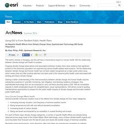
MapHub · Create interactive maps. VIS. Visual Investigative Scenarios platform: About. OpenHeatMap. ColorBrewer: Color Advice for Maps. Using GIS to Form Resilient Public Health Plans. As Negative Health Effects from Climate Change Grow, Sophisticated Technology Will Guide Preparation By Alex Philp, PhD, Upstream Research, Inc.
The earth's climate is changing, and this will have a tremendous impact on human health. But the relationship between climate change and health is complex. Ongoing climate change observations and associated prediction models show clear evidence that significant portions of the American population are experiencing various health-related repercussions. Yet the relationship between climate change and human health has not been widely recognized as a major public policy issue, which means that very little practical attention has been paid to the massive public health costs associated with existing and future climate change.
Gaining a better understanding of the interconnections between climate change and human health requires substantial investment in scientific monitoring, risk mitigation, and devising resiliency strategies. About the Author. Turn street patterns into objects. Green Infrastructure for the U.S. Terrapattern. What Happened to Google Maps? — Justin O'Beirne. MapHub · Create interactive maps. Technology: Use or lose our navigation skills. Paul Grogan/PhotoPlus Magazine via Getty Images The paths of vehicles along Regent Street in London, revealed by long-exposure photography.
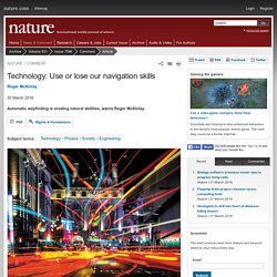
In 1984, I was part of a team that was developing a receiver for a satellite-navigation system. After weeks of debugging, the blur of random digits settled on a location. We grabbed a map and plotted the point. The pencilled cross landed exactly on the building that we were in. Navigation has invaded our dreams of the future. Outils cartographiques - Les projections cartographiques. Beyond the sea. By Andy Woodruff on 24 March 2016 In the northern reaches of Newfoundland, near the town of St.
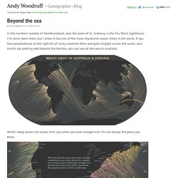
Anthony, is the Fox Point Lighthouse. I’ve never been there, but I know it has one of the most impressive ocean views in the world. Why Google Maps gets Africa wrong. About halfway through Jonathan Swift's boisterously witty epic poem On Poetry: A Rhapsody, the 18th century Anglo-Irish satirist briefly turns his attention to maps of Africa, writing: So geographers, in Afric maps,With savage pictures fill their gaps,And o'er uninhabitable downsPlace elephants for want of towns.
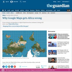
In Swift's time, European explorers had only skirted around the coastal edges of Africa and its interior remained, to all intents and purposes, a mystery. Canadian Immigrants Interactive Map. Making a multilingual map of India using OpenStreetMap data. One of the main reasons I was convinced of the power of OSM when I first started to edit 8 years ago was the possiblity of seeing maps in my native language Tamil, spoken by 70 million people, which was till then unheard of.
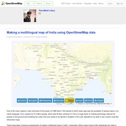
This is a huge factor in making technology relevant for people on the ground and breaking the notion that one needs to be literate in English or the Latin alphabet to be able to use modern tools like interactive maps. 27 Ideas for Teaching with USGS Topographic Maps. Powered by Translate The USGS publishes approximately 57,000 different topographic maps covering the United States.
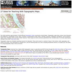
Topographic maps show contour lines (elevation and landforms), hydrography (rivers, lakes, marshes), transportation (roads, trails, railroads, airports), vegetation, boundaries, survey markers, urban areas, buildings, and a variety of other features. These maps are most commonly published at the 1:24,000 scale (7.5 minute quadrangle), although many other map scales exist.
Topographic maps are a fantastic teaching resource for educators. Materials. Robin Tolochko. Over the years, I have been collecting a list of my go-to resources for cartography and web design. I’ve never found a comprehensive list of where to go for anything from selecting colors to finding data, so I figured I should just make mine public to help you out (though it is by no means comprehensive). Please contact me if you have any suggestions of resources to add to this list. General mapping stuff Thematic Cartography Guide: Axis Maps’ amazing thematic cartography guideOpenStreetMap: Editable, open map of the world.mapschool.io: Brief introduction to all things geo.20 Unrequested Map Tips: John Nelson’s 20 map-making tips Web mapping. Tips and Tricks. Vast canyons are awe inspiring. They thwart quests, halt armies, and tell the tale of vast cataclysms from times past. In this quick tutorial I’ll outline how to draw a canyon on your fantasy map.
Amazon. Amazon. Amazon. Utpjournals. Studio SSS. Maperitive. ArcGIS - Geodatabases and Feature Classes. Create PNG Title for Web Map. Creating Map layouts in QGIS. OpenLayers 3 - Welcome. Polymaps. MapOSMatic: Welcome! How to make digital maps. 30 brilliant tips for creating Illustrated maps. From Paper Maps to the Web: A DIY Digital Maps Primer. Leer versión en español Lire en Français I was invited to the National Library of Colombia’s 2nd Digital Book Week as a speaker and to give a workshop on digital mapping tools. I thought it would be useful to share that workshop since it encompasses a lot of different processes and tools that make digital cartography today very accessible.
It is a primer on working with various free web mapping tools so you can make your own awesome maps. You will make this. Geo-referencing the scanned map so that web tiles can be generated generating GeoJSON data to be overlaid creating a custom base map (to serve as reference/present day) integrating all assets in an interactive web page Note: This tutorial assumes you are using Mozilla Firefox, Apple Safari or Google Chrome. Can I legally share this map? Copyrights of maps. A map is worth a thousand words, every map lover knows that. Many of us share maps on Twitter, Facebook or Instagram and blogs like Geoaweosmeness write about them. But are we allowed to do that? Maps should be treaded like any other intellectual property or a piece of art. As a general rule, you can’t publish a map or an image which is not owned by you without the permission of the author or the owner, unless the image is covered by something like a Creative Commons license used by OpenStreetMap.
In fact the law gives the copyright owner the right to decide where their work is published. 5 books and atlases you need to have on your map shelf. We love maps. Since you’re reading that post you must be a map addict as well. Our spatial obsession makes us not only make maps, use maps, play with maps and write about them. We also love reading books about location and cartography. Below you’ll find 10 books and atlases which should have on your map shelf: