
New Maps Reveal California's Sensational Seafloor Geography. An unprecedented effort to map the seafloor bordering California’s coastline has produced some of the most detailed, beautiful and useful maps of an underwater landscape ever made.
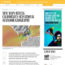
No fewer than 18 state and federal agencies and institutions led by the US Geological Survey banded together to make these maps. A staggering amount of work went into the California Seafloor Mapping Program, and the results are impressive. “Nowhere else in the world are people pursuing comprehensive seafloor mapping at this scale,” said USGS geologist Sam Johnson, the agency’s lead scientist on the project. “It’s really unprecedented globally.” The maps could be important for studying things like navigation safety, coastal erosion and sea level rise, fisheries, and earthquake and tsunami hazards. The scale of the project, started in 2007 by the California Ocean protection Council, is staggering. Sensational Geography Changes to come The maps show an unwelcome dearth of sediment along the San Francisco peninsula.
10 Tips to Customize Maps with Google Map Builder. Online users now get to easily search for specific places like hotels, restaurants, venues, etc. as many websites now have map support.
Among content management system platforms, there are now various geolocation-based themes available. But before you can have this in your site, you need to use tools like the Google Map Builder. To have this feature, they make use of Google Map. This is considered to be a highly powerful map services on the web today. Using the default sign might appear dull. Overview Google Map Builder provides you with a user interface where you are provided with the options found in the left panel. Granular Map Control With Google Maps, you can have complete control when it comes to settings.
Add Custom Marker One of the easiest ways to customize maps and to make it look more creative is to add customer marker. About the GIS Day Mission. GIS Day provides an international forum for users of geographic information systems (GIS) technology to demonstrate real-world applications that are making a difference in our society.
The first formal GIS Day took place in 1999. Esri president and co-founder Jack Dangermond credits Ralph Nader with being the person who inspired the creation of GIS Day. He considered GIS Day a good initiative for people to learn about geography and the uses of GIS. He wanted GIS Day to be a grassroots effort and open to everyone to participate. GIS Day is One Fun Day to Celebrate GIS with everyone Discover and explore the benefits of GIS Showcase the uses of GIS Build and nurture your GIS community Future Dates 2014 – Wednesday, November 19, 20142015 – Wednesday, November 18, 20152016 – Wednesday, November 16, 20162017 – Wednesday, November 15, 2017. eLearning Tools-Resources-etc. 4 Tools to Compare the True Size of Maps - Instant Fundas. Toolbox Getting to Know Google « Inclusive Learning. Google World Wonders Project. What are Continents? Watch a Mongolian family assemble their yurt in fast-forward video.
Tsunami Infographic. Speeding Around The World in Under 5 minutes Time Lapse. Maps with Street View. Alright everyone.
Despite my complete melt-down further up in this comments thread, I need to put something out there. Disclosure first: although I have access to certain sources, I (and my business) am independent of Google but have direct dealings with Google. I have NDAs that prohibit me from disclosing certain things. I will mind my manners and my NDAs in writing this. These are my words and should be taken as only that. August didn't go according to plan, completely. YouTube was very quick to adopt 360° video but YouTube is comparatively MUCH smaller than Google Maps and incorporating 360° video didn't require a major overhaul because it's still a niche and people are more forgiving of products that serve a niche. 360° photography, on the other hand, has moved from niche to mainstream and made the Street View brand (when tied directly and only to Maps) irrelevant very quickly.
Transparency is crucial to Google's success. Tour the Amazon with Google Street View; No Passport Needed. Ride the railroad with Google Street View. Marble. Map of The World - Shaded Relief. MapMaker - National Geographic. Qibla Locator. If It Were My Home. Google Maps Colorizr. Google Maps – Adding Pictures. Flood Map Water Level Elevation Map. Daylight Saving Time Explained. David Rumsey Historical Map Collection. Better World Flux.