
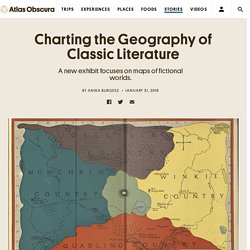
Maps, Set of 5 maps of the world, by Ortelius, first edition! – Philographikon Antique Maps and Prints. Ortelius World Maps The world, America, Asia, Africa, Europe Set of 5 maps.
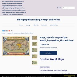
Copper etchings from the Atlas "Theatrum Orbis Terrarum" by Abraham Ortelius. Antwerp, 1570. Verso text: Latin. Excellent hand coloring in the typical Renaissance style. This homogenous set derives from an atlas printed in the year 1570. The first edition of the Ortelius atlas had very narrow margins. "Typus Orbis Terrarum" Shirley 122; van den Broecke 1; Koeman/Meurer 1 World map: 33.2 x 49.8 cm (13.1 x 19.6").has left and right margin extended.
"Africae Tabula Nova" van den Broecke 8; Koeman/Meuer 4 Africa: 37.5 x 50.7 cm 14.8 x 20"). "Americae sive Novi Orbis, Nova Descriptio" van den Broecke 9; Koeman/Meurer 2 America: 36.7 x 50.8 cm (14.4 x 20") has left, right and lower margins extended. "Europae" van den Broecke 4; Koeman/Meurer 5 Europe: 33.2 x 46.1 cm (13.1 x 18.1")Needed no extension.
"Asiae Nova Descriptio" van den Broecke 6; Koeman/Meurer 3 Asia: 37 x 49.5 cm (14.6 x 19.5"). Drawing Color Hillshade: A tutorial (with time lapse videos) – Cartography & Dataviz. Last year I shared my technique for drawing hillshade with graphite (pencil).
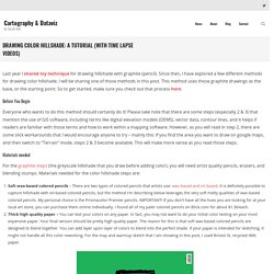
Since then, I have explored a few different methods for drawing color hillshade. I will be sharing one of those methods in this post. Fictions cartographiques au temps du corona - Julien Dupont. Capucine Gros Exhibits ‘Implicit Borders: A Cartography of Free Will’ – WWD. “I’ve always been quite obsessed with maps,” says artist Capucine Gros on a sunny afternoon from Catinca Tabacaru Gallery in the Lower East Side of Manhattan, where she was putting the finishing touches on her solo show “Implicit Borders: A Cartography of Free Will.”
Gros grew up between Switzerland, France and China before landing in New York, where she currently resides. “Traveling always feels like putting pieces of a puzzle together and also just the concept of nationality itself,” she continues, speaking with a hard-to-place accent. “Not really knowing where you’re from exactly, and wondering, well, why are we so constrained by these lines?
They are necessary, but how much importance do we let them have in our lives? '” She explores the concept of borders — emotional and physical — through much of her work. Discover Fascinating Vintage Maps From National Geographic's Archives. Cartography has been close to National Geographic’s heart from the beginning.
And over the magazine’s 130-year history, maps have been an integral part of its mission. Now, for the first time, National Geographic has compiled a digital archive of its entire editorial cartography collection — every map ever published in the magazine since the first issue in October 1888. The collection is brimming with more than 6,000 maps (and counting), and you’ll have a chance to see some of the highlights as the magazine’s cartographers explore the trove and share one of their favorite maps each day. Follow @NatGeoMaps on Twitter, Instagram, and Facebook to see what they discover. (The separate map archive is not available to the public, but subscribers can see them in their respective issues in the digital magazine archive.) Jo Mora's Maps Brought California History to Life. RADICI STUDIOS...ce n'est pas de la carto...mais c'est si beau! L'Instruction en France en 1867 / par J. Manier, ... Japan Map Drawing 2019.
Amateur cartographer spent 4,000 hours hand drawing North America in minute detail In a world defined by readily accessible digital maps, Anton Thomas proves that traditional cartography isn’t a lost art form after all.
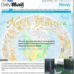
In 2014, the self-taught artist based in Melbourne, Australia challenged himself to hand draw the entire North American continent. The endeavor resulted in an almost five-year-long passion project that culminated in a resplendently animated pictorial map, measuring 4x5 feet, titled North America: Portrait of a Continent. The cartouche, or emblem of the map is pictured above. Mapping a Nation: Japan’s Most Famous Cartographer, Inō Tadataka. Inō Tadataka was 55 years old when he set out to methodically survey the entire coastline of Japan, a task he would spend the next 17 years of his life completing.
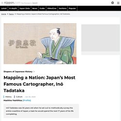
A Monumental Undertaking During the latter part of the Edo period (1603–1868), geographical surveyor Inō Tadataka (1745–1818) set to work charting the coastline of Japan, a mammoth undertaking that consumed the last decades of his life. Inō would die at the age of 73, before seeing his life’s work completed in the form of a map of the nation based on his survey activities. But he is recognized as the first person to survey the entirety of Japan using modern scientific techniques. His collection of highly accurate maps served as the basis of the mapmaking efforts of the modern Meiji government.
Old Maps Online. David Rumsey Historical Map Collection. New York Public Library Showcases Rare City Maps in New Exhibit. Podmap. En cartes, le désorientant monde vu d'Asie. Create your own map in a new museum. Index.html?gallery=//cdn.cnn.com/cnnnext/dam/assets/180627103034-fuller-map-2. Des cartes de villes chinoises aux perspectives renversantes - Pacha cartographie. Si les plans de villes sont généralement vite compréhensibles (c’est un peu le but) il en est d’autres qui nécessitent d’être longuement observées avant de livrer tous leurs secrets.
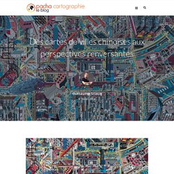
C’est clairement le cas de ces panoramas urbains pour le moins déstabilisants qui représentent des villes et quartiers chinois en mélangeant allègrement les perspectives, les angles et les directions. Avec une esthétique pop proche de la bande dessinée, ces cartes n’hésitent pas à dévoiler aussi bien l’organisation du quartier que la vie qui s’y déroule. A Map Of Shoreditch Street Art. Will Noble A Map Of Shoreditch Street Art Interested in street art, but don't know your Stik from your Senna?
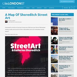
Remember seeing a really cool mural of a fish in Shoreditch, but can't remember exactly where? Then this map is for you: Compiled by The Stage, the interactive map pinpoints the locations of street art around the east London locale that's slathered in the stuff. Atlasobscura. “Other maps are such shapes, with their islands and capes!
But we’ve got our brave Captain to thank:”(So the crew would protest) “that he’s bought us the best - A perfect and absolute blank!” Not all literary maps are as charmingly obtuse. Spain’s Royal cartographer, Tomás López, designed a gloriously detailed copperplate map of Don Quixote and Sancho Panza’s travels. Madeleine de Scudéry’s 17th-century novel Clélie includes the famous Carte de Tendre, an allegorical map showing the path to love (beware the Lake of Indifference!). 17th-century adult colouring-in book ready for modern hues. Adults finding time for colouring-in books might seem a modern fad, part of the fashion for all things mindful.
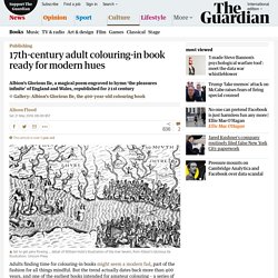
But the trend actually dates back more than 400 years, and one of the earliest books intended for amateur colouring – a series of maps adorned with delicately drawn images of nymphs, water sprites and fairies – is about to be republished, centuries after it was first printed. The maps in Albion’s Glorious Ile, out in June from Unicorn Press, were commissioned to illustrate the poet Michael Drayton’s 17th-century, 15,000-line poem, Poly-Olbion. Describing England and Wales – Drayton didn’t get round to Scotland – the vast poem tours the country, county by county, evoking the topographical features and legends of each location. “Of Albions glorious Ile the wonders … I write, / The sundry varying soyles, the pleasures infinite,” writes Drayton, in the poem he dubbed his “strange Herculean labour” and spent 30 years honing. Jeux cartistiques - Agnès Stienne. European Bus Maps : the State of the Art – Jug Cerovic.
The notion that Europe has superb public transit does not always extend to the quality of public transit maps. I have studied more than 250 European cities and their bus maps, and have also designed a few. Here are some observations about the state of the practice. All transit maps fall within two main categories: geographic maps that show the real scale and distances, and schematic maps that help you see the network structure.
Atlasobscura. To hear Admiral Bartholomew de Fonte tell it, his voyage was full of serendipity and promise. In a 1708 edition of the English periodical The Monthly Miscellany or Memoirs for the Curious, de Fonte recounted a journey, some five decades prior, “to find out if there was any North West Passage from the Atlantick Ocean into the South and Tartarian Sea.” He had shoved off from Lima, he wrote, and navigated to the present-day Pacific Northwest, where he entered an intricate system of watery arteries that beckoned him inland. He chronicled one fortuitous scene after another. 11590. Rotating Planets — Visionscarto. Maps are art in a thought-provoking New York exhibition.
Vintage maps, books and more in UW Libraries Special Collections exhibit ‘All Over the Map’ "Cartografías de lo desconocido": Usted está aquí. King Arthur's Avalon, Sandy Island, and Other Imaginary Islands On Maps. By Simon Worrall In the age of GPS and Google Maps, it is hard to believe that maps can include places that don’t exist. But author Malachy Tallack argues that maps are as much “a cartography of the mind” as they are a way to figure out where we are. In his new book, The Un-Discovered Islands, Tallack takes readers on a journey to imaginary places—mythic islands, mapmakers’ mistakes, mirages, and outright hoaxes. [Find out how explorer Robert Peary discovered a continent that wasn’t there.]
Nouvelle Américopasique. 15 cartes de Noël – Carnet. Cartographie artistique : recettes créatives pour éplucher une orange - David M. Swart. J’adore les oranges. Elles sont sucrées. Des cartes polynésiennes en bois pour re... Newly Unveiled 16th-Century Map Shows a World Filled with Centaurs and Unicorns. Les cartographies d'enfants du concours Barbara Petchenik : les gagnants de 2017. Cartographers to Watch in 2018 (Part One) – MapPorn. Un tissu périurbain cousu main - Agnès Stienne et Morgane Blot, Emma Thébaud, Chloé Lebret et Naïma Lecomte. Tyler Rollins Fine Art - Artists - Tiffany Chung. Tiffany Chung (Vietnam/USA) is noted for her cartographic drawings, sculptures, videos, photographs, and theater performances that examine conflict, migration, displacement, urban progress and transformation in relation to history and cultural memory.
She is one of Vietnam’s most respected and internationally active contemporary artists. Her work was featured in the 2015 Venice Biennale, in the exhibition All the World’s Futures in the Arsenale, with an installation of 40 map-based drawings relating to the ongoing crisis in Syria. The works’ richly detailed surfaces, with jewel-like tones rendered in ink and paint stick on translucent vellum, belie their somber thematic content charting the country’s ever expanding cycles of violence and refugee displacement. Chung’s work studies the geographical shifts in countries that were traumatized by war, human destruction, or natural disaster. Artist Michelle Chandra Turns City Street Maps into Mazes.
Why Ancient Mapmakers Were Terrified of Blank Spaces. The Indian Ocean is teeming with sea monsters in Caspar Vopel’s 1558 map of the world. A giant swordfish-like creature looks to be on a collision course with a ship, while a walrus with frighteningly large tusks emerges from the water, and a king carrying a flag rides the waves on a hog-faced beast. Four Centuries of Mapping the Subterranean World. Des cartes fictives en l’honneur de la nature - Pacha cartographie. Voici quelques œuvres du designer danois Jeppe Knudsen Ringsted. Sa série Mappa Animalia est conçue comme un hommage à la nature et à l’ensemble du monde animal. Son très beau travail illustre la symbiose existante entre le règne animal et le milieu naturel. Vivant à Aarhus, il a grandi à la campagne et a développé un amour pour l’écologie qui se reflète dans ces œuvres impressionnantes.
How Trompe-L’Oeil Added Information and Ornamentation to Maps. Cartographers have often added ornamental flourishes to their maps, whether sea monsters in the Medieval and Renaissance eras that attempted to describe ocean life, or octopuses in more modern maps that suggested a spreading evil. In the 18th century, philosophers were considering the connection between sight and touch, an idea that made its way into the world of mapmaking. Look But Don’t Touch: Tactile Illusions on Maps from the Harvard Map Collection explores this emergence of illusions on cartography.
Look But Don’t Touch involves both an extensive online exhibition, and a display at the Map Collection in Harvard University’s Pusey Library. David Weimer, librarian for cartographic collections and learning at the Map Collection, told Hyperallergic that the exhibition was inspired in part by his research on embossed atlases for the blind, which got him thinking about how cartographers expressed space as something visual.
Dirks LEGO world map. The Underappreciated Man Behind the “Best Graphic Ever Produced” Take part in the discussion! Color Palettes of The New Yorker - C82 : Works of Nicholas Rougeux. Going through old papers my dad gave me, I found his map of the internet as of May 1973. The entire internet. CaGIS Annual Map Design Competition. The Cartography and Geographic Information Society (CaGIS) has announced their Annual Map Design Competition. La ville de l'avenir sous le crayon des collégiens - Manon Boisseau, Léopold Marchand, Thomas Brault, Claire Kjerulf, Aela Guet, Agathe Prébet, Amaëlle Kelfoun, Elsa Masson, Élise Cocault, Lisa Paimparé. Catherine Jourdan, psychologue et artiste, mène une démarche originale de cartographie subjective.
Superstitions of the Middle Ages, produced in the 1930s. Le cirque européen après la seconde guerre mondiale et sa paix précaire, affiche portugaise. #WW2 #Europe #Paix #Cartoon. (1) De Moulinsart à Célesteville, panorama des villes de BD. #Expo Collectif Autrement #Verneuil/Avre 5-31/07 #art cont. Magnifique "Ne pas regarder le soleil dans les yeux"
Each Week, #MapMonsterMonday Celebrates Historical Cartographic Beasts. Uk.businessinsider. Carriers of the New Black Plague: the dictatorial domination of individual and public opinion, 1938. [1189×755] : MapPorn. Quand Mondrian rencontre PONG, mon cœur saigne. Each Week, #MapMonsterMonday Celebrates Historical Cartographic Beasts. Cover and pages from The Colorist, 1913, by J.... Old map by BÜNTING -Asia secunda pars terrae in forma Pegasi. [Asia is presented as the mythical winged horse Pegasus]. Mapping Sound, by Zoë Ambrose. In Arlington condo, couple find colorful way of putting their dining room on the map. Top 14 des cartes de villes françaises version honnête, tout de suite c’est plus clair. Étude 01 série I - Formes angulaires et arrondies. Five people who revolutionized map making. Map-a-Day – October 2015 – Emerald Samurai.
Paper cut leaf map of Amsterdam #map #maps. Looking at the Big Picture: Adapting Film Theory to Examine Map Form, Meaning, and Aesthetic. Fuir Berlin en 1938 : L'odyssée familliale vue par Fritz Freudenheims 11 ans #shoah. Cartographie de l'humain : une exposition itinérante - 26/11/2015. Globemaker Peter Bellerby, the man with the world in his hands. The Philatelic Institute’s Stamp Map of the World,... This 1752 British Map Shows California as an Island. A Burmese Map of the World. Commission on Map Design. Jouons cartes sur table : la géographie vaincra.
A Wonderfully Stereotypical 1970s Map of New York. Jc fichet sur Twitter : "Deep dream maps show #cartography at its most beautiful MT via @CartogRRaphy... LEGO micro World Map - If you ♥ LEGO, come have a look at LEGO LOVE board - I am the French-Israeli d… The Witcher - Interactive Animated Map. This beautiful map shows what Canada's future looked like in 1955. MI LABORATORIO DE IDEAS: australia: the world's centre.
«Beauté Congo»: l’art congolais, une créativité unique en Afrique. Friday Favorite: Beatrice Gilbert - Mixed-Media Map Art. Cp_mecenat_globes_dnp. L'homme du commerce. PALMARES. Geofumadas sur Twitter : "La Cartografía de como nos ven los demás. ¡Buenísimo! The most expensive paintings sold in Europe, in one gorgeous map. Pendersleigh & Sons Cartography. Zombie-town USA. Map-of-the-internet-10-explore-this-beautiful-handdrawn-map-of-the-online-world-9098834. Jc fichet sur Twitter : "Jolie #cartographie d'un paysage de #maths via @ValeriePestre #strange_map... Tangram Sandbox. JERRY GRETZINGER. Impression de monde carte n 11 aquarelle par JessicaIllustration. Metro-style world map.