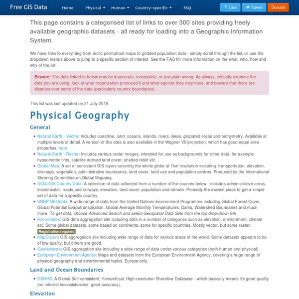
Updated Snow GIS data « Robin's Blog
September 25, 2012 A while back I released a GIS dataset containing Snow’s Cholera analysis data in modern GIS formats, and georeferenced to the British National Grid (see my previous post). Unfortunately, there was an error in some of the attributes of the Cholera Deaths shapefile which caused issues when using the data.
Free 7.5 Minute, 250K Topographic TOPO and Terrain Maps
Sponsors <-- Return To Download Free Maps Free U.S. 250K 1:250000 TOPO Maps - 1,400+ beautiful highly detailed, high resolution scans of original U.S. 250K ( 1:250000 ) topographic maps. Inlcudes index map of Alaska and lower 48 including Hawaii. Free USGS DRG Topographical TOPO Maps - Digital Raster Graphics (DRG) files are scans of 7.5-minute USGS topographic maps. USGS Geographic Geospatial Download: DEM, DLG, LULC.
Create a topographic profile
Import file (KML, KMZ, GPX) loaded layer and topographic profile of the route. Sometimes, some files do not automatically create a profile! Zoom: 15Counter markers: 2Status: REQUEST_DENIEDАzimuth: 73°Mouse px: ...Lat./Lon.: ...Center point: -25.343780041796837, 131.03412500000002Center point location: ... How to make a topographic profile? Reset Find your area of interest on the map Select the cursor min. 2 points (max. 300) Ready – site profile will be generated in seconds Embed the chart on your site Copy and save the link to the chart Add the route to the map
PredictionX: John Snow and the Cholera Epidemic of 1854
In 1854, a cholera epidemic swept through the London neighborhood of Soho. In the course of about three weeks, over 600 people died. This incident was, tragically, not unusual in London or the rest of the 19th century world as a whole. The scourge of cholera seemed unstoppable and, even worse, unpredictable.
Common Metadata Repository (CMR)
*NOTE: The Common Metadata Repository (CMR) has replaced NASA's Earth Observing System (EOS) Clearing House (ECHO). What is CMR? NASA's Common Metadata Repository (CMR) is a high-performance, high-quality, continuously evolving metadata system that catalogs all data and service metadata records for NASA's Earth Observing System Data and Information System (EOSDIS) system and will be the authoritative management system for all EOSDIS metadata. These metadata records are registered, modified, discovered, and accessed through programmatic interfaces leveraging standard protocols and APIs. CMR tools and services include:
John Snow's data journalism: the cholera map that changed the world
How often does a map change the world? In 1854, one produced by Doctor John Snow, altered it forever. In the world of the 1850s, cholera was believed to be spread by miasma in the air, germs were not yet understood and the sudden and serious outbreak of cholera in London's Soho was a mystery. So Snow did something data journalists often do now: he mapped the cases. The map essentially represented each death as a bar, and you can see them in the smaller image above. It became apparent that the cases were clustered around the pump in Broad (now Broadwick) street.
IUCN Red List of Threatened Species
Spatial Data & Mapping Resources The IUCN Red List of Threatened Species™ contains global assessments for 105,732 species. More than 75% of these (81,323 species) have spatial data. The spatial data provided below are for comprehensively assessed taxonomic groups and selected freshwater groups. It is important to note that some species (such as those listed as Data Deficient) are not mapped and subspecies, varieties and subpopulations are mapped within the parental species.
How to Change the Projection of a Shapefile Using QGIS
All geographic data is tied to some projection or coordinate system. If you know the starting coordinate system or projection of your shapefile, you can quickly export the data into another coordinate or projections system using QGIS. What Files Are Needed to Reproject a Shapefile? To start with, you will need a projection file stored in the same directory as the rest of the shapefile files. Despite being in the singular, the shapefile is actually a set of files.
Geospatial Revolution Project Explored
Penn State Public Broadcasting has released a web-based series of videos called the Geospatial Revolution Project , the first episode of which debuted in September of 2010: The project will feature a web-based serial release of video episodes—each telling an intriguing geospatial story. Overarching themes woven throughout the episodes will tie them together, and the episodes will culminate in a 60-minute documentary. Geospatial Revolution Episode 1: Introduction to Geospatial technologies The first episode (also viewable below) moves very rapidly over the timeframe of mapping and the development of geospatial technologies starting with etched Babylonian maps dating from 2300 B.C on up to today’s geospatial advances. The episode segues into how users have gone from being passive recipients of geographic information to active participants in the collection and reporting of that information.