
ERA Interim, Daily. Amir AghaKouchak - Software. Nonstationary Extreme Value Analysis (NEVA) Software Package The Nonstationary Extreme Value Analysis (NEVA) software package has been developed to facilitate extreme value analysis under both stationary and nonstationary assumptions.
In a Bayesian approach, NEVA estimates the extreme value parameters with a Differential Evolution Markov Chain (DE-MC) approach for global optimization over the parameter space. NEVA includes posterior probability intervals (uncertainty bounds) of estimated return levels through Bayesian inference, with its inherent advantages in uncertainty quantification. The software presents the results of non-stationary extreme value analysis using various exceedance probability methods. We evaluate both stationary and non-stationary components of the package for a case study consisting of annual temperature maxima for a gridded global temperature dataset. Click Here to Read More and Download Source Code Standardized Drought Analysis Toolbox (SDAT) HBV Hydrologic Model. The observational record. Untitled Document. Solar Insolation Tool for analyzing solar radiation.
Mahmud.Geneva: Online Data. Introductory words: Climate change and its impact assessment has strike through a great attention these days, especially after wining the Nobel peace prize in 2007 by AL Gores team with IPCC.
Huge number of universities and research organizations started working on climate impact assessment. Like geographic data, climatic data’s are not as straight forward to extract from online resources. Various reasons involved for this problem, most often climatic data’s are uploaded in gridded points with various temporal and spatial scale. Therefore, in this post we are going to see where we can get online data for climatic research and how we can utilize them. . [1] National Climatic Data Center, USA (NCDC) CGMS-IPWG, Data. George J.
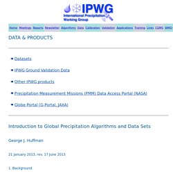
Huffman 21 January 2013, rev. 17 June 2013 1. Background In the modern age the good news is that there is a rich selection of precipitation products from which data users can choose. Global (or nearly global) coverage, with multi-year periods of record, that are publicly available. At the surface, the only observations that support the requirements for spatial coverage and length of record are precipitation gauges (popularly referred to as "rain gauges"), and even they suffer large gaps, principally over oceans and in in sparsely settled land regions. In the next two sections the algorithms and data sets are introduced. 2.
Algorithms are the computational procedures used to convert satellite and surface data into precipitation estimates. The precipitation signal in microwave data actually results from two physical effects, emission and scattering. BfG - The GRDC. This is the Global Runoff Data Centre, a repository for the world's river discharge data and associated metadata.
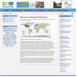
GRDC stations with monthly data, indicated by time series end The GRDC is an international archive of data up to 200 years old, and fosters multinational and global long-term hydrological studies. Originally established two decades ago, the aim of the GRDC is to help earth scientists analyse global climate trends and assess environmental impacts and risks. Positioned as a facilitator for exchanges between data providers and data users, the GRDC has become a focal point for international cooperation. Researchers, universities and other organisations make use of the facilities available for research programmes and projects. The Global Runoff Database at GRDC is a unique collection of river discharge data collected at daily or monthly intervals from more than 9,200 stations in 160 countries.
CWC Hydro-meteorological sites - From Introduction Central Water Commission has contributed substantially in collection of hydrological data all over the country.

Being the apex national body for the development of surface water resources of the country, the Central Water Commission has established a network of hydrological observation stations in all the river basins. Hydro-meteorological sites (HMSHydro-Meteorological Sites) of CWCCentral Water Commission are stations responsible for the collection of hydrological, meteorological and water quality parameters. Data Available and Frequency of Observations From some such stations the data is reported once a day while others report it on twice daily or four times a day basis. Data for each of the observed parameter reported once in a day at 0830 hrs (daily climatic data) Data for each of the observed parameter reported twice a day at 0830 and 1730 hrs. Current Scenario in India where G, D, S, Q, RF indicates Gauge, Discharge, Sediment , Water Quality and Rainfall.
Description.