Where did English come from? - Claire Bowern
There are two other TED-Ed lessons related to this topic: How languages evolve and How did English evolve? (a lesson that fills in some of the details that we omit here due to the fact that the focus of this lesson was further in the past). There is still a great deal of debate about Indo-European, most importantly about the location of the homeland.
Word Map
This experiment brings together the power of Google Translate and the collective knowledge of Wikipedia to put into context the relationship between language and geographical space. Please let us know if you have any suggestions. Note that not all languages are currently supported by Google Translate. To browse, just zoom in/out, pan around and click on the word to learn more.
Photographs That Hold History
A photo can capture much more than what's put in front of the lens. In one moment and one limited frame, an entire piece of history can shine through. These 30 incredible shots capture times past, but have cultural impacts that resonate even today. They are chilling, quotidian, and inspiring. They speak to our collective past. 1.
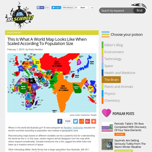
Cartography: The true true size of Africa
LAST month Kai Krause, a computer-graphics guru, caused a stir with a map entitled "The True Size of Africa", which showed the outlines of other countries crammed into the outline of the African continent. His aim was to make "a small contribution in the fight against rampant Immappancy"—in particular, the fact that most people do not realise how much the ubiquitous Mercator projection distorts the relative sizes of countries. A sphere cannot be represented on a flat plane without distortion, which means all map projections distort in one way or another.
City WebQuests: Sydney: history and traditions
This webquest will help you investigate Sydney: its history, music and famous landmarks. You will also plan a trip and send a postcard home. Downloadable worksheet and teacher's notes are available at the bottom of the page. Activity 1: Introductory quiz Visit the link below: Look at the page and, in pairs or small groups, find the answers to the following eight questions on the history of Sydney and Australia.
Sign In
Type the email address of the account you want to sign in with. We're having trouble locating your account. Which type of account do you want to use? Sign in to Office 365 Which type of account do you want to sign in with? Make sure you typed the user ID assigned to you by your organization.
map_what_europe_would_look_like_if_all_the_separatist_movements_got_their
This article originally appeared in Business Insider. The Scottish independence movement will embolden other active separatist groups in Europe to win their freedom, whether or not Scotland votes to secede from the UK on Thursday. From Catalonia and Basque Country in Spain to Veneto, South Tyrol, and the island of Sardinia in Italy to Flanders in Belgium, "the precedent of the vote on self-determination will reverberate around the Continent," the New York Times writes. If you want a rough idea of how European borders would have to be redrawn if regions with a separatist agenda got their way, you can look at the map below, put together by the European Free Alliance, to which "40 progressive nationalist, regionalist and autonomous parties throughout the European Union" belong. European Free Alliance
World Population Cube - Views of the World
Last November’s theme of the Super Science Saturday at the Oxford University Museum of Natural History was Planet Earth. As part of the activities I contributed a map cube which I created a few years ago.Cubic globes are not a new idea. They put a nice twist to showing just a simple map, and more importantly, they allow for some activity which get the kids involved just as much as adults. A cube is much less work than creating a spheric version of Earth, and (as said by Carlos Furuti on his online cube globe collection) the cube is an ideal introduction to folding one’s own pseudoglobes.