
Back to the Future on the San Andreas Fault. Exposure of the San Andreas Fault in a trench.
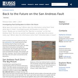
The horizontal colored lines highlight different layers of sediment. The red line is traced on a fault that offsets the layers. (Credit: Kate Scharer, USGS. Public domain.) Earth scientists have been gathering data at key paleoseismic sites along sections of the San Andreas Fault to figure out the past timeline of earthquakes at each spot. San Andreas Fault Zone – The Big Picture Scientists have a good big picture understanding of the San Andreas Fault Zone (SAFZ). 500-year-old Leaning Tower of Pisa mystery unveiled by engineers. Ancient Chinese Seismometer Used Dragons and Toads. In 132 AD, Chinese astronomer Zhang Heng created a seismometer, a device that detects the ground’s movement during an earthquake.

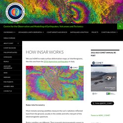
It couldn’t predict quakes but it did show what direction they were coming from — even when they were hundreds of miles away! How InSAR works - Centre for the Observation and Modelling of Earthquakes, Volcanoes and Tectonics. We use InSAR to make surface deformation maps, or interferograms, like this one from the 2016 Apennines earthquakes in Italy.
Radar interferometry Most remote sensing satellites measure the sun’s radiation reflected back from the ground, usually in the visible and infra-red part of the electromagnetic spectrum. Radar satellites are different. They transmit electromagnetic waves to illuminate an area of the Earth’s surface, and record the amplitude and phase of the waves that bounce back.
Unit 4: The phenomenology of earthquakes from InSAR data. These materials have been reviewed for their alignment with the Next Generation Science Standards as detailed below.
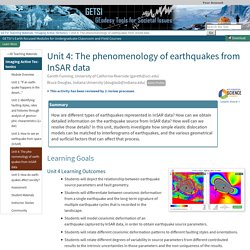
Visit InTeGrate and the NGSS to learn more. Overview Students use models to simulate interactions between surface displacement and landscapes. They quantify fault geometry using InSAR data, relating different degrees of variability in source parameters to different results. : Volcano Hazards Program. Interferogram image made from InSAR monitoring, showing 1995-2001 ground-uplift pattern centered 5 km (3 mi) west of South Sister volcano, Oregon.
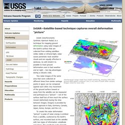
(click for more info) Yellowstone ground movement map from Sept 2004 - Aug 2006. InSAR (Interferometric Synthetic Aperture Radar) is a technique for mapping ground deformation using radar images of the Earth's surface that are collected from orbiting satellites. Unlike visible or infrared light, radar waves penetrate most weather clouds and are equally effective in darkness. Watch the Ridgecrest earthquake shatter the desert floor in stunning before-and-after images. Millions felt the shaking from the Ridgecrest earthquake.
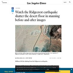
But new satellite images offer a dramatic and instructive view of the immense power of the magnitude 7.1 quake, showing how California’s biggest earthquake in nearly two decades caused the ground to break. Animated slides show how the quake permanently jolted a huge block of earth northwest while the other side of the fault moved southeast. Some of the clearest images show long scars on the surface of the Mojave Desert, indicating precisely the 30 miles of earthquake fault — oriented in a northwest-southeast direction — that moved within moments on July 5.
“I’ve never seen this before,” said Brian Olson, engineering geologist with the California Geological Survey. San Andreas Fault Field Guide. Some sections of the San Andreas Fault system in San Francisco Bay Area are locked, overdue. Four urban sections of the San Andreas Fault system in Northern California have stored enough energy to produce major earthquakes, according to a new study that measures fault creep.

Three fault sections -- Hayward, Rodgers Creek and Green Valley -- are nearing or past their average recurrence interval, according to the study published in the Bulletin of the Seismological Society of America (BSSA). The earthquake cycle reflects the accumulation of strain on a fault, its release as slip, and its re-accumulation and re-release. Fault creep is the slip and slow release of strain in the uppermost part of the Earth's crust that occurs on some faults between large earthquakes, when much greater stress is released in only seconds. Where no fault creep occurs, a fault is considered locked and stress will build until it is released by an earthquake. This study estimates how much creep occurs on each section of the San Andreas Fault system in Northern California. Exploring Earthquakes. Were Mexico’s September Quakes Chance or a Chain Reaction? Four months ago, a magnitude 8.1 earthquake and subsequent tsunami brought death and destruction to Mexico’s Gulf of Tehuantepec, an area that hadn’t seen strong earthquakes in 2 centuries.

Less than 2 weeks later, a 7.1 quake rocked Mexico City, the nation’s capital, and the nearby populous region of Puebla. A natural question arises. “Did the earthquakes occur in a chain reaction or by coincidence?” Asked Shinji Toda of Tohoku University in Japan. Fs2014 3018. Seismic History: The Deadly 1985 Mexico City Earthquake. On this day in 1985, a magnitude 8.0 earthquake rocked Mexico City and its surrounding environs at 9:17 a.m.
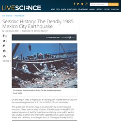
EDT (7:17 a.m. local time). The quake was felt as far away as Guatemala City, Guatemala and Houston, Texas, over an area of about 319,000 square miles (825,000 square kilometers), but the most intense shaking occurred in Mexico City, Ciudad Guzman and the Pacific Coast towns of Lazaro Cardenas, Ixtapa and La Union, according to the U.S.
Geological Survey (USGS). Building Resonance: The resonant frequency of different seismic waves- Incorporated Research Institutions for Seismology. Why do some buildings fall in earthquakes?
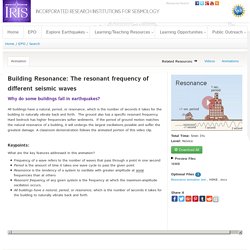
All buildings have a natural, period, or resonance, which is the number of seconds it takes for the building to naturally vibrate back and forth. The ground also has a specific resonant frequency. Hard bedrock has higher frequencies softer sediments. If the period of ground motion matches the natural resonance of a building, it will undergo the largest oscillations possible and suffer the greatest damage. Earthquake Testing movie. Movie courtesy of NSF. Scientists are using the world's largest "shake table" to test new construction methods for buildings in areas prone to earthquakes. They believe they have devised a system to build taller, wood-frame buildings that can still safely withstand even very powerful tremors.
Right-click (Windows) or Option-click (Mac) here to download a copy of this video in QuickTime format. Shop Windows to the Universe Science Store! Animations for Earthquake Terms and Concepts. Earthquake Intensity- Incorporated Research Institutions for Seismology. Geophysics Unit of Menlo Park-GUMP. For additional information see the following publications: Watt, J.T., Graymer, R.W., Simpson, R.W., Ponce, D.A., Jachens, R.C., Phelps, G.A., and Wentworth, C.M., 2007, A Three-dimensional geologic model of the Hayward-Calaveras Fault junction: Eos Trans.
AGU, v. 88, no. 52, Fall Meet. Suppl. Water cycle - animated diagram. Images - Multimedia Gallery Page 2. 2014 South Napa CA M6 Earthquake - August 24. 2014 Napa earthquake continued to creep, weeks after main shock: Continuing seismic activity could pose additional hazards to infrastructure. Nearly two years ago, on August 24, 2014, just south of Napa, California, a fault in Earth suddenly slipped, violently shifting and splitting huge blocks of solid rock, 6 miles below the surface. The underground upheaval generated severe shaking at the surface, lasting 10 to 20 seconds. When the shaking subsided, the magnitude 6.0 earthquake -- the largest in the San Francisco Bay Area since 1989 -- left in its wake crumpled building facades, ruptured water mains, and fractured roadways. Shaking of Frontier Building — Anchorage, Alaska, During Mw7.1 Earthquake, January 24, 2016.
Animations for Earthquake Terms and Concepts. Earthquakes for Kids. Virtual Earthquake - An Introduction. What's an earthquake? Earthquakes occur because of a sudden release of stored energy. Fault Motion Animations : IRIS. Explaining Earthquakes - KQED QUEST. The Science Behind the 1906 Earthquake. A New Earthquake-Proof Calaveras Dam - KQED QUEST. The Hayward Fault: Overdue for Disaster - KQED QUEST. Shaking Things Up: 10 Resources for Exploring Earthquakes. Does the anniversary of the 1906 San Francisco earthquake trigger a landslide of questions from your students about why earthquakes happen, what faults are, or if scientists can predict quakes? Seismic Waves - 2004 Sumatra Quake & Tsunami.
Jumbo Seismic Monitor. IRIS Earthquake Browser. IRIS: MB5.1 North Korea. Quake or Bomb? Seismic Waves Speak Truth, Even If Nations Don't. Last week, North Korea tested what it claimed to be a hydrogen bomb, or as the North Korean government declared in its official statement, an “H-Bomb of justice.” However, it’s not likely that North Korea has actually developed a hydrogen bomb and successfully tested it on 6 January local time (the evening of 5 January on the U.S. East Coast), as announced. The U.S. Geological Survey recorded the subsequent seismic event as having a 5.1 magnitude, which is much lower than would be expected from such a powerful weapon. But even if North Korea or anyone else conducting a clandestine nuclear test makes no announcement, seismologists can still figure out if an underground bomb test or an earthquake took place by analyzing how energy propagates from the seismic event in question.
Explosions Send Compression Waves in All Directions P waves are the fastest-moving type of seismic waves. Bigger Interior Waves Suggest an Explosion. A Tested, Inexpensive Way to Protect Buildings from Earthquakes — NOVA Next. Cloaking Buildings from Earthquakes and Tsunamis — NOVA Next. How an Earthquake, Tsunami, and Firestorm All Hit Lisbon at Once. StructureDesign. IRIS - Incorporated Research Institutions for Seismology. Incorporated Research Institutions for Seismology. IRIS - Incorporated Research Institutions for Seismology.
How does a seismometer measure horizontal ground motion? IRIS - Incorporated Research Institutions for Seismology. IRIS - Incorporated Research Institutions for Seismology.