Exploding Taupō. Volcanoes often occur at the boundary where two tectonic plates meet.
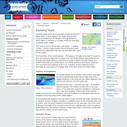
In New Zealand, the Taupō Volcanic Zone (TVZ), extending from Mt Ruapehu through Rotorua to White Island, is the front of a wedge where the Australian and Pacific plates collide. The volcanic zone is named after Lake Taupō – a caldera volcano – where a large eruption several thousand years ago formed a depression that has naturally filled with water to form a lake. Volcano map of New Zealand. New Zealand Te Puke, Bay of Islands A scoria cone volcano that last exploded around 1,300–1,800 years ago.
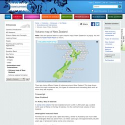
Located north-west of Paihia in the Bay of Islands, it is the northernmost volcano in New Zealand. Whāngārei Volcanic Field Formed over a hot spot (not a plate boundary), similar to Auckland, but much older. Auckland Volcanic Field A volcanic field that covers around 360km2 under Auckland city. Little Barrier Island An extinct andesite cone. Mayor Island Mayor Island last erupted around 500-1000 years ago. White Island. Volcanoes and Volcanic Eruptions - Facts and Information. Mount Vesuvius, Italy: Map, Facts, Eruption Pictures, Pompeii. Mount Vesuvius Introduction Vesuvius is the only active volcano in mainland Europe, and has produced some of the continent's largest volcanic eruptions.
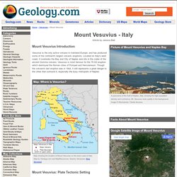
Located on Italy's west coast, it overlooks the Bay and City of Naples and sits in the crater of the ancient Somma volcano. Vesuvius is most famous for the 79 AD eruption which destroyed the Roman cities of Pompeii and Herculaneum. Though the volcano's last eruption was in 1944, it still represents a great danger to the cities that surround it, especially the busy metropolis of Naples. Mount Vesuvius: Plate Tectonic Setting Vesuvius is part of the Campanian volcanic arc, a line of volcanoes that formed over a subduction zone created by the convergence of the African and Eurasian plates.
Mount Vesuvius: Eruption History Mount Vesuvius has experienced eight major eruptions in the last 17,000 years. Starting in 1631, Vesuvius entered a period of steady volcanic activity, including lava flows and eruptions of ash and mud. Did You Know? Taranaki (Egmont) Volcano - Volcano. The last major eruption of Taranaki (also known as Egmont Volcano) occurred around 1854; the mountain dominates the productive farmland of the Taranaki region.
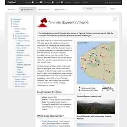
Taranaki/Egmont network map. Canterbury quake / Recent Events / Natural Hazards / Our Science / Home. 6.3 magnitude earthquake part of aftershock sequence February the 22nd's devastating magnitude 6.3 earthquake centred southeast of Christchurch was part of the aftershock sequence that has been occurring since the September magnitude 7.1 quake near Darfield, 40km west of the city, an earthquake geologist said today.
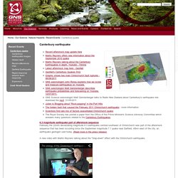
(Read more in the press release). A new video with Martin Reyners talking about the "Slap-down" effect with the Christchurch earthquake. GNS Science has started issuing a daily graphic showing the probability of strong earthquake shaking in the mid part of the South Island between Cheviot and Timaru and across to the west coast. GNS Science Natural Hazards Platform Research Manager, Dr Kelvin Berryman, answers some questions related to the magnitude 6.3 earthquake in Christchurch on TV3's Campbell Live programme on 3 March 2011.
GeoNet short-cut to frequently asked questions. GNS seismologist Bill Fry explains the February 2011 aftershocks in Christchurch. Press releases Images. Tectonics of the M7 earthquake near Christchurch, New Zealand. This post was written in response to the Darfield earthquake in September 2010.
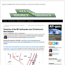
The most recent seismic activity is discussed here. [Updated 8th September 1200 GMT – see bottom of post. And check out the PodClast discussion of this earthquake, featuring Kiwi Chris Town, Ron Schott, and myself.] The South Island of New Zealand has just been shaken by a large earthquake, reported as a magnitude 7.0 by the USGS. It appears to be quite a shallow rupture, on the Canterbury Plains close to Christchurch, and the focal mechanism indicates largely strike-slip motion. Canterbury and Christchurch earthquakes - Geological Sciences - University of Canterbury - New Zealand.
Shallow, intermediate, and deep foci. Shallow, intermediate, and deep foci Most parts of the world experience at least occasional shallow earthquakes—those that originate within 60 km (40 miles) of the Earth’s outer surface.
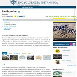
In fact, the great majority of earthquake foci are shallow. It should be noted, however, that the geographic distribution of smaller earthquakes is less completely determined than more severe quakes, partly because the availability of relevant data is dependent on the distribution of observatories. Of the total energy released in earthquakes, 12 percent comes from intermediate earthquakes—that is, quakes with a focal depth ranging from about 60 to 300 km. About 3 percent of total energy comes from deeper earthquakes. Earthquake. Causes of earthquakes earthquake: global seismic centres in 1975–1999Encyclopædia Britannica, Inc.Earth’s major earthquakes occur mainly in belts coinciding with the margins of tectonic plates.
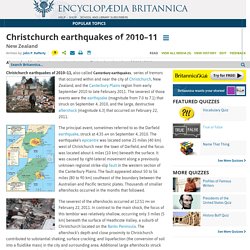
This has long been apparent from early catalogs of felt earthquakes and is even more readily discernible in modern seismicity maps, which show instrumentally determined epicentres. Christchurch earthquakes of 2010-11. Christchurch earthquakes of 2010–11, also called Canterbury earthquakes,