
Frozen Planet: Explore the polar regions. Click on the image below to start exploring the Arctic and Antarctic.
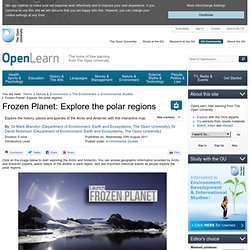
You can access geographic information provided by Arctic and Antarctic experts, watch videos of the wildlife in each region, and see important historical events as people explore the polar regions. Copyrighted image Credit: The Open University Launch Frozen Planet 9 Special thanks to British Antarctic Survey 10 for their assistance in developing this interactive map. Please note: If you've arrived at this page looking for our Frozen Planet poster, thank you for your interest, but unfortunately, demand for this item was very high and we have now exhausted our current supplies.
40 Maps That Will Help You Make Sense of the World. If you’re a visual learner like myself, then you know maps, charts and infographics can really help bring data and information to life. Maps can make a point resonate with readers and this collection aims to do just that. Hopefully some of these maps will surprise you and you’ll learn something new.
A few are important to know, some interpret and display data in a beautiful or creative way, and a few may even make you chuckle or shake your head. If you enjoy this collection of maps, the Sifter highly recommends the r/MapPorn sub reddit. You should also check out ChartsBin.com. 1. 2. 3. 4. Pangea was a supercontinent that existed during the late Paleozoic and early Mesozoic eras, forming about 300 million years ago. Antarctica - science(6,7) - ABC Splash - Add this to your favourites Antarctica The first recorded expedition to Antarctica was in 1821.
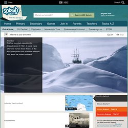
It was a place where no human lived. Thanks to the work of explorers and scientists we know a lot about the frozen continent. About this digibook Antarctica: harsh continent view Early explorers browse Surprising evidence by 1904 watch Mawson expedition: 1911-14 watch Shackleton expedition: 1914-16 view In Shackleton's footsteps watch Mawson's Hut watch Aurora australis watch Research today watch Research stations view About this collection More on Antarctica Who is this for?
Primary. Great Barrier Reef - science(5,6,7,8) - ABC Splash - Add this to your favourites Great Barrier Reef Australia's Great Barrier Reef is the world's largest coral reef and the richest natural ecosystem in the world.
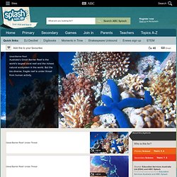
But the bio-diverse, fragile reef is under threat from human activity. About this digibook Great Barrier Reef: Under Threat view Great Barrier Reef: Under Threat view Ecology watch Fragile ecosystem watch Human threats play Impact of climate change view Impact of mining, logging and farming watch Impact of overfishing view Impact of destructive fishing view Impact of tourism view Reef rescue view Action for the future view About this collection More on the Great Barrier Reef Who is this for? Primary Science Years: 5, 6 Secondary Years: 7, 8 Source: Education Services Australia Ltd (ESA) and ABC Splash Find more resources from Education Services Australia and ABC Splash Copyright information Belongs to the topic: Teaching Resources. Xpeditions is now archived in National Geographic Education's new website—natgeoed.org If you liked Xpeditions, you'll love the new media-rich natgeoed.org.
Explore the new site now for activities, maps, interactives, videos, homework help, and more! Www.natgeoed.org Please note: to search for Xpeditions content, check the “include archive” filter. Grades K-2. Map Projection Types. Cylindrical Projection A cylindrical projection map is the most common type of map that we see.
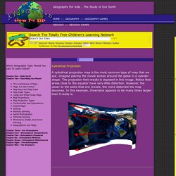
Imagine placing the movie screen around the globe in a cylinder shape. The projection that results is depicted in this image. Notice that areas close to the equator have very little distortion. However, the closer to the poles that one travels, the more distorted the map becomes. Conic Projection A conic projection map is created by placing a cone shaped screen on a globe. Plane Projection A plane projection is created by placing an imaginary screen directly above or below a globe. Biomes of Our Earth: Major Life Zones. Introduction to Biomes.
3D Geography - helping with the teaching and learning of Geography. 3D Geography - helping with the teaching and learning of Geography. Quiz Whiz: Geography. World Geography Games - Let's play and learn about the world.