
GeoHack - Toolserver wiki. GeoHack is a modified version of map sources from Egil Kvaleberg's gis extension.
It is designed to do simple HTML replacements of a template on Wikipedia and serve it to the client. It is used by Wikipedia to provide links to various mapping services, when a user clicks on a link with geographical coordinates. Different layout designs for GeoHack are listed on w:Template:GeoTemplate/sandbox. Query language. Welcome to the Quantum GIS Project. ILWIS GIS / REMOTE SENSING SOFTWARE. SAGA - System for Automated Geoscientific Analyses. OpenJUMP GIS. Autodesk project cooper open source alternative. GPS Visualizer.
Map a GPS data file with Google Earth. This form will import your GPS data file (e.g., GPX), or plain-text data (tab-delimited or CSV), and create a KML file that you can view in the Google Earth application or import into Google's "My Maps"/"My Places" system.
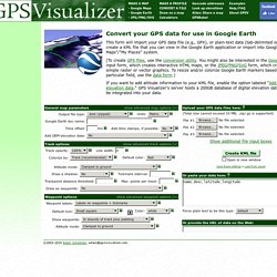
(To create GPX files, use the conversion utility. You might also be interested in the Google Maps input form, which creates interactive HTML maps, or the JPEG/PNG/SVG form, which creates simple raster or vector graphics. To resize and/or colorize Google Earth markers based on a particular field, use the data form.)