
Fixin Streams: Converting a Drawing Datum in AutoCAD Map 3D 2011. Converting your drawing’s datum in not a straightforward, user-friendly task in Map 3D.
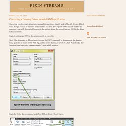
It is not difficult to do, though, and can be mastered after some trial and error. Two separate DWG files are used for this procedure – one with the original linework in the original datum; the second in a new DWG in the datum to be converted to. Begin by setting up a DWG in the datum you wish to convert to. Next, if the datums are in different units, then use the UNITS command. In this example, the drawing being queried is in meters (UTM WGS-84), and the native drawing is in feet (VA State Plane South). Begin the Define Query command under Tool Ribbon>Create>Object Query. The Define Query command sets up parameters for importing drawing information from other DWG files. Select the relevant drawing and add. Drawing are locked when they are actively queried. The Define Query>Drawings command shows the currently active drawings. Now set the query type. USGS Topography showing before/after querying: Fixin Streams: Import Garmin Mapsource GPS tracks into AutoCAD & Civil 3D.
Garmin Mapsource can export tracks for use in AutoCAD Map 3D.
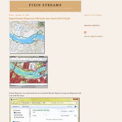
Begin by saving your Mapsource track in the DXF file format Make note of the UTM zone for your datum settings in Map 3D. Use the dialog box settings as shown for saving the DXF file. A 3D polyline will be created if the Include elevation information box is checked, otherwise the track will be a normal polyline. A warning message appears if the track/waypoint information overlays more than one UTM Zone Now open the DXF file in Map 3D. Adjust the datum of the DXF file just opened to be the same datum of the Mapsource tracks and waypoints that were just saved. Also, BE SURE TO CHANGE DRAWING UNITS TO METERS.
The track is now imported into AutoCAD Map 3D on the UTM84 datum. Application GPS gratuite. Garmin Map. GPX (format de fichier) Un article de Wikipédia, l'encyclopédie libre.
Pour les articles homonymes, voir GPX. GPX (GPS eXchange Format) est un format de fichier permettant l'échange de coordonnées GPS. Ce format permet de décrire une collection de points utilisables sous forme de point de cheminement (waypoint), trace (track) ou itinéraire (route). Ce format est ouvert. Sa version la plus utilisée est le format GPX v 1.1 mais il existe encore des logiciels comme ITN Converter qui utilisent la version 1.0. La racine du fichier (<gpx>) peut contenir : <? <? À l'exception de GPX et de KML, devenu standard de l'Open Geospatial Consortium, ces formats sont propriétaires et spécifiques à une marque et aux logiciels associés (Navteq, Tele Atlas, ViaMichelin).
CSV : Garmin, Navman, Navigon (il n'y a pas de norme geo-csv, le CSV n'est donc pas très structurant et chaque logiciel l'utilise différemment)OV2 : TomTom, CoPilot LiveASC : ViaMichelinKML, KMZ : Google Earth, OziExplorerTRK : CompeGPS Logiciels pour Windows. GPS Mapping Software for Garmin, Magellan, Lowrance, Eagle GPS. [TUTO] – Ajouter une carte gratuitement dans son GPS Garmin (avec ou sans BaseCamp) – B'Caching. Vous venez d’acheter un GPS Garmin pour vos randonnées, sorties VTT, ou bien pour les sorties géocaching, et vous n’avez pas de carte (la majorité du temps) dans votre appareil ?
![[TUTO] – Ajouter une carte gratuitement dans son GPS Garmin (avec ou sans BaseCamp) – B'Caching](http://cdn.pearltrees.com/s/pic/th/ajouter-gratuitement-basecamp-141952549)
Voici comment ajouter GRATUITEMENT une carte de France ou d’un autre pays dans votre nouveau jouet. J’utilise le site Freizeikarte qui met à disposition les cartes OSM (Open Street Map : un standard open source de cartes topographiques pour appareil GPS, smartphones, tablettes…). Les mises à jour sont disponibles tous les 2 mois environ (en moyenne).
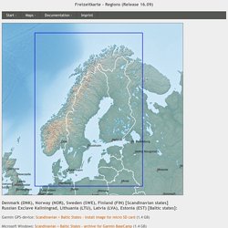
Freizeitkarte - Regions. Denmark (DNK), Norway (NOR), Sweden (SWE), Finland (FIN) [Scandinavian states] Russian Exclave Kaliningrad, Lithuania (LTU), Latvia (LVA), Estonia (EST) [Baltic states]: Garmin GPS-device: Scandinavian + Baltic States - install image for micro SD card (1.4 GB) Microsoft Windows: Scandinavian + Baltic States - archive for Garmin BaseCamp (1.4 GB) Apple Mac OS X: Scandinavian + Baltic States - install archive for Garmin BaseCamp (1.4 GB)
OpenFietsMap. Free worldwide Garmin maps from OpenStreetMap.