
North Carolina – Lord of Maps. Worlds Revealed: Geography & Maps at The Library Of Congress. This is a guest post by Kelly Bilz, Librarian-in-Residence in the Geography and Map Division.
Even though Latin had fallen out of vernacular use after the fall of Rome (and began to evolve into the modern Romance languages), it lived on in its written form, becoming the lingua franca, so to speak, of scholarship. In particular, western cartographers during the Renaissance used Latin in their maps, resulting in a large collection of maps in the Geography and Map Division written in this ancient language.
Seeing these polysyllabic words in a long list of search results can be disorienting; fortunately, being familiar with a couple key terms can help you navigate Latin titles with ease– without having to study Latin for eight years, as I did! Mappa totius mundi : adornata juxta observationes dnn. academiae regalis scientiarum et nonnullorum aliorum secundum annotationes recentissimas. Map by Guillaume de L’Isle and Tobias Conrad Lotter, 1775. Imperium Romano-Germanicum. Learn more: The Inverted World Map - Variations on a Blue Marble - 3Develop image blog.
It probably happens to everyone who likes to look at maps.
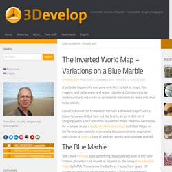
You imagine land to be water and water to be land. Continents to be oceans and and oceans to be continents. Islands to be lakes and lakes to be islands. I could not resist the temptation to make a detailed map of such a topsy-turvy world. But I am not the first to do so. Royal Collection Trust. Mercator Misconceptions: Clever Map Shows the True Size of Countries. Since their invention, automobiles have been a driving force of the global economy. Used by millions of people to get to work, transport goods, and travel, the modern automobile has become ubiquitous in our daily lives.
So much so, that a whopping 92 million cars were produced in just 2019. To help us understand the might of the auto industry, this infographic from Parts Geek breaks down the earnings of 19 major car companies by an interesting metric—revenue per second. The Full List of Automakers. Historic Urban Plans - Historic Urban Plans. Map scale – Fantasy Maps for fun and glory. Off the chart: the big comeback of paper maps. When I was living in Yemen during the 1980s, someone gave me a battered old map.
Information was scarce then, and accurate maps were extremely hard to come by. So departing expatriates tended to pass on any treasures to new arrivals. As he did so, my benefactor paused. - Cornell University Library Digital Collections Search Results. Medieval Fantasy City Generator by watabou. This application generates a random medieval city layout of a requested size.
The generation method is rather arbitrary, the goal is to produce a nice looking map, not an accurate model of a city. Maybe in the future I'll use its code as a basis for some game or maybe not. Click one of the buttons to create a new city map of a desired size. Hover the mouse pointer over a building to see the type of the ward it belongs to. Press and hold SPACE to see all ward labels. 👉For development news and related stuff please check a dedicated reddit community. The Difference Between The Mercator Projection And Countries' Real Geographic Sizes, Visualized. According to a report from real estate information site Trulia, there are currently 838 neighborhoods in the US that have a median home value of $1,000,000 or more.
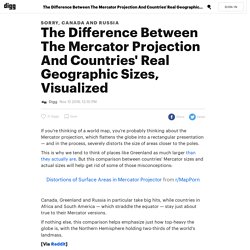
Perhaps unsurprisingly, most of these neighborhoods are highly concentrated in only a few states. California, in particular, is home to some of the priciest neighborhoods in the US. With roughly two-thirds of the million dollar neighborhoods in the US, California has by far the highest number of million dollar neighborhoods in the country, with New York and Florida occupying a very distant second and third. Old Maps Online. City Street Orientations around the World - Geoff Boeing.
This post is adapted from this research paper that you can read/cite for more info. It analyzes and visualizes 100 cities around the world. Vote for this project in the 2018 Information Is Beautiful Awards! By popular request, this is a quick follow-up to this post comparing the orientation of streets in 25 US cities using Python and OSMnx. Creation of fantasy maps by Robert Altbauer. Check out this map of all the languages currently spoken in the world. I COME FROM a part of France that likes to think of itself as separate from the rest of the country: Brittany. So much so that if I had been born 50 years earlier I would probably have been speaking Breton rather than French with my immediate relatives. But with time and “unifying” language policies, Breton has faded in the background and French has taken over.
This map shows the literal meaning of every country’s name. Index. Stephen Biesty - Illustrator. World Map: The Literal Translation of Country Names. The Soviet Military Program that Secretly Mapped the Entire World. During the Cold War, the Soviet military undertook a secret mapping program that’s only recently come to light in the West.
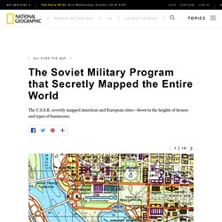
Military cartographers created hundreds of thousands of maps and filled them with detailed notes on the terrain and infrastructure of every place on Earth. It was one of the greatest mapping endeavors the world has ever seen. Soviet maps of Afghanistan indicate the times of year certain mountain passes are free of snow and passable for travel.
Maps of China include notes on local vegetation and whether water from wells in a particular area is safe to drink. The Soviets also mapped American cities in remarkable detail, including some military buildings that don’t appear on American-made maps of the same era. More Accurate World Map Wins Prestigious Design Award. The most accurate map you'll ever see.

You probably won't like it. Authagraph You probably don’t realize it, but virtually every world map you’ve ever seen is wrong. And while the new AuthaGraph World Map may look strange, it is in fact the most accurate map you’ve ever seen. Incredibly Detailed Map Of The World's Religions. Map created by reddit user scolbert08 The incredibly detailed map of the world’s religions above, was created by reddit user scolbert08.
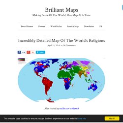
To see the full resolution version just click on it. It shows what the biggest religion is by census area in each country, along with its level of support. For example, in large parts of British Columbia the most common answer on the census is no religion, but the intensity of that feeling varies widely. Another important thing to note is that while Christianity is divided between Catholicism, Protestantism and Orthodox denominations, Islam is not similarly divided between Sunnis and Shias.
Over 300 Historical City Maps. PDF Quads - Trail Maps. FREE Printable USGS PDF TOPO!
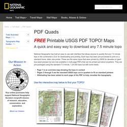
Maps A quick and easy way to download any 7.5 minute topo National Geographic has built an easy to use web interface that allows anyone to quickly find any 7.5 minute topo in the continental U.S.A. for downloading and printing. Each topo has been pre-processed to print on a standard home, letter size printer. These are the same topos that were printed by USGS for decades on giant bus-sized presses but are now available in multi-page PDFs that can be printed just about anywhere. National Park Maps. Central Intelligence Agency’s albums. What's the best map projection? Next term, I’ll be teaching a course in general relativity, and while preparing my notes on the curvature of space, I was reminded of a really fun paper I worked on with Rich Gott a few years ago.
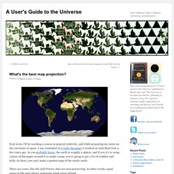
As you probably know, the earth is roughly a sphere, and if you try to wrap a piece of flat paper around it to make a map, you’re going to get a lot of crinkles and folds. In short, you can’t make a perfect map of the whole earth. There are some, like the Gall-Peters, that are area-preserving. In other words, equal areas on the map always represent equal areas of land. Map Projections.
The True Size Of ... Ezilon Maps - Regional Reference Maps. Cheats guide to making simple outline maps in Photoshop - Red Dice Diaries. Please note: There are some excellent and very professional cartographers out there producing great maps for games, this article is not designed to create a map to compete with them, it is for someone who wants to quickly put together a simple map that they can use during a RP campaign with minimal struggle.
Producing professional looking campaign maps can be very tricky, takes a lot of practice and time, however, if you’re just looking for a quick map that will enable you to get playing your game quickly then this guide should help you. This article assumes you have access to Photoshop and basic ability to use it (although the principles should be transferable to other graphic programs like GIMP). Open a new screen Start up your graphics program and open a new image. Digital Atlas of the Roman Empire. Map Age Guide. Natural Earth. Archival mylar polyester sleeves, sheet protectors, page protectors. Flag Stories.
Victorian London in Incredible Detail. Here’s a real treat. Anglo-Saxon London Map. The full map in overview. Catacombs Of Paris. Explore georeferenced maps - Map images. History Map Archive. Atlantis Map. Osher Map Library. A sneak preview of 3D Imaging at the Osher Map Library and Smith Center for Cartographic Education. Moving forward into the future of digitizing our cultural heritage, OML’s Digital Imaging Center is engaged in an innovative project to three-dimensionally image the library’s rare globe collection, the second-largest of its kind in a U.S. public institution.
Appalachian Mountain Club's Equipped: Nearly Every USGS Topo Map Ever Made. For Free. The U.S. History of Cartography: Volumes One, Two, and Three. The Assault of Berlin Illustrated Russian Book 1948 USSR Maps Photos. Collections with Maps. Old maps of Seven Seas (Open Ocean) How does it work? These instructions will show you how to find historical maps online. Getting started. Brian DiMambro Antique Maps and Prints. An Illustrated Guide to Space Maps. Nebra Sky Disc, Germany, 1600 BC. (Photo: Rainer Zenz/WikiCommons CC BY-SA 3.0) With its patinated bronze background and shiny gold sun, moon and stars, the 3600-year-old Nebra Sky Disc is worth gazing at for its beauty alone. But the ancient object is cool for a lot of other reasons: It’s the earliest depiction of outer space we’ve ever found, and it’s also thought to be the oldest known portable astronomical instrument.
For as long as humans have stared at the sky, we have sought to understand our place in the cosmos. USGS Historical Topographic Maps. Real World Maps vs Fantasy Maps. American Geographical Society Library Digital Map Collection. Inside The Most Amazing Map Library That You've Never Heard Of. The American Geographical Society Library at the University of Wisconsin, Milwaukee.
Maps.stamen.com. 20 maps that never happened. Maps are a powerful way of illustrating not only the world that is, but worlds that never have been. What follow are not fictional maps — there's no Westeros or Middle Earth — but plans and hypotheticals that never came to pass. Alternate History Africa Map. Big Map Blog. Campaign Cartographer Tutorials by Joe Sweeney. Digitized Medieval Manuscripts Maps (DMMmaps) Mapire: Historical Maps Of The Habsburg Empire. Wagner & Debes Cartographers. Visual History of War, Religion, and Government. Theban Mapping Project. Animated map of history: 3000BC to 1000AD. The Perfect 22-Foot Map for Your Ancient Roman Road Trip.