
Cheats guide to making simple outline maps in Photoshop - Red Dice Diaries Please note: There are some excellent and very professional cartographers out there producing great maps for games, this article is not designed to create a map to compete with them, it is for someone who wants to quickly put together a simple map that they can use during a RP campaign with minimal struggle. Producing professional looking campaign maps can be very tricky, takes a lot of practice and time, however, if you’re just looking for a quick map that will enable you to get playing your game quickly then this guide should help you. This article assumes you have access to Photoshop and basic ability to use it (although the principles should be transferable to other graphic programs like GIMP). Open a new screen Start up your graphics program and open a new image. So there you are, using this method it’s possible to create a basic outline map for an RPG in about ten minutes or so (quicker once you’ve had a bit of practice).
(#03) Rynek Główny, Wieża Ratuszowa - Dawno temu w Krakowie - archiwalne i aktualne zdjęcia Krakowa Zdjęcie archiwalne pochodzi ze zbiorów Narodowego Archiwum Cyfrowego. Kliknij tutaj, aby zobaczyć je w bazie NAC. Zdjęcie zostało wykonane w 1931 roku. Krakowski ratusz przybierał na przestrzeni wieków wiele form. Oto krótka jego historia na podstawie Wikipedii: Krakowski ratusz wzniesiony został na przełomie XIII i XIV wieku, najstarsza informacja źródłowa o ratuszu pochodzi z 1313 lub 1316 roku. W dniu 1 marca 1817 roku uchwalono co następuje: Ponieważ część gmachu starym Ratuszem zwanego od dawna na spichrze obrócona w stanie opustoszałym znajduje się; te więc spichrza mają być zburzonymi kosztem skarbu i materiał na fabrykę skarbową użyty.
GIS and Digital Humanities ~ GIS Lounge Humanities-based research has increasingly become more computationally focused, where topics of text analysis, digital reconstruction, networks, and spatial analysis have been among the key research areas. A recent edited volume by Crompton et al. (2016) demonstrates how spatial-based digital humanities has become one of the primary focus areas for many different types of humanities scholars.[1] While some of the work is quantitative-based, other work has been qualitative. One area, for instance, has been understanding historical data, such as major events or historical development, based on spatial analysis. In fact, this has given rise to spatial history as a large area within historical research, where many key actors, events, and timelines are interpreted through spatial relationships. The Role of GIS in the Digital Humanities An example of research using text analysis and GIS. The Rise of Digital Humanities as an Academic Field Growing Employment of GIS Experts in Digital Humanities
40 maps that explain the Roman Empire by Timothy B. Lee on August 19, 2014 Two thousand years ago, on August 19, 14 AD, Caesar Augustus died. He was Rome's first emperor, having won a civil war more than 40 years earlier that transformed the dysfunctional Roman Republic into an empire. Under Augustus and his successors, the empire experienced 200 years of relative peace and prosperity. Here are 40 maps that explain the Roman Empire — its rise and fall, its culture and economy, and how it laid the foundations of the modern world. The rise and fall of Rome The rise and fall of RomeIn 500 BC, Rome was a minor city-state on the Italian peninsula. The rise of Rome Rome's military Rome's powerful maniple formation Rome's powerful maniple formationIn the early years of the republic, the Roman infantry used a version of the Greek phalanx. The republic becomes an empire The lost city of Pompeii The eruption of Mount Vesuvius The eruption of Mt. The culture of Rome Roman Britain and the Roman economy The decline of Rome Rome's legacy
Natural Earth (#65) ul. Lwowska po likwidacji getta krakowskiego, widoczne porzucone pakunki - Dawno temu w Krakowie - archiwalne i aktualne zdjęcia Krakowa Zdjęcie archiwalne zostało wykonane w marcu 1943 roku. Krakowskie getto powstało w marcu 1941 roku na terenie dzielnicy Podgórze i obejmowało 15 ulic lub ich fragmentów. Na obszarze getta znajdowało się 320 domów, a w nich 3167 pokojów, w których przed utworzeniem getta mieszkało około 3 tys. ludzi. Po wzniesieniu murów, wybudowaniu czterech bram i zamurowaniu okien wychodzących na „aryjską” stronę miasta, przesiedlono do getta 16 tysięcy ludzi. Metraż na jedną osobę wynosił zaledwie 2 m². Ta sama ulica, ten sam dzień, kilka chwil wcześniej. Getto przetrwało dwa lata. Dzisiaj przyglądamy się tej właśnie ostatecznej likwidacji getta, a właściwie temu co pozostało na ulicach Podgórza, gdy likwidacja została zakończona. Nowe zdjęcia Krakowa dodajemy regularnie, chcesz wiedzieć kiedy?
Mapping for the Out of Eden Walk project | Center for Geographic Analysis, Harvard University The Out of Eden Walk is a 21,000-mile journalistic endeavor to create a global record of human life at the start of a new millennium as told by villagers, nomads, traders, farmers, soldiers, and artists who rarely make the news. Sponsored and hosted by National Geographic Society, the project is led by Pulitzer Prize winning writer Paul Salopek who is walking the path of human migration across the globe, and recording what he encounters in the form of writing, photographs, video, and audio. As a partner in this project the CGA’s role includes mapping Paul’s walking route from his GPS data, custom thematic map creation, and essay writing by the CGA's Jeff Blossom featured in the Map Room. Toward the project's educational focus the CGA has provided hands on cartographic education centered around the Walk to 6th grade through college age students. Map 1 below: Shows exposed sea beds at the human migration started, and the rough path humans took.
Free data, statistics, analysis, visualization & sharing - knoema.com archival mylar polyester sleeves, sheet protectors, page protectors U-570 poddanie okrętu Takiego wydarzenia nie notowano od początku wojny. Gdy w dniu 27 sierpnia 1941 roku załoga samolotu patrolowego Lockheed „Hudson” z 269 dywizjonu obrony wybrzeża RAF poszła na start, nikt zapewne nie mógł przypuszczać, jaką sensację przyniesie ta wyprawa. Latali tak prawie codziennie, jeśli tylko dopisywała pogoda, kierując się nad Atlantyk w poszukiwaniu niemieckich okrętów. Trasa wiodła od wyspy Lewis na Morzu Szkockim, gdzie stacjonował ten dywizjon, do rejonu Islandii na północy, przecinając wschodni akwen oceanu na odcinku ponad 800 kilometrów. Tym właśnie szlakiem płynęły w dwustronnym ruchu alianckie konwoje i tu także pojawiał się napastnik, w powietrzu bądź pod wodą, idąc w pełnym zanurzeniu. Aktywność Niemców na Atlantyku w tym okresie zaczęła jakby przygasać. Najbardziej dotkliwie odczuwali Niemcy stratę wyszkolonych załóg i czołowych „asów" wojny podwodnej. Pałeczkę przejął radiotelegrafista, wystukując pilne wezwanie do własnych okrętów i łodzi latających.
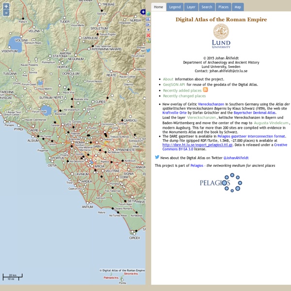
Digitizing the Fall of the Roman Empire | Center for Geographic Analysis, Harvard University DARMC Project website From a general survey of the later Roman empire from ca. 250 to 700, the course "History 11111: The fall of Roman Empire" is shifting to an investigation of the question of the fall of the Roman Empire. It will emphasize archaeology, primary written sources in translation, web-based resources, and the application of new natural scientific methods to historical and archaeological problems across the entire Roman world. Today’s students are more visually oriented than yesterday’s, and more digitally aware in general, prompting the move from static wall maps to interactive and infinitely adaptable digital maps. The project created the first high quality digital maps of the Roman Empire which is suitable for continuous improvement and adaptation in teaching and research worldwide. The CGA also organized trainings to facilitate students’ use of the digital maps in section and in their research.
Roads to Rome Roads to Romes (US) Following this fact, we adjusted our routing to find the closest Rome to every location in the USA. Each color represents routes leading to the closest Rome of this very starting point. Adjusting and coloring the routing to multiple destinations resulted in a very interesting territorial picture. As we know the melting pot is the home of many Americans who centuries ago migrated from Europe. A way of interpreting the spatial pattern of Romes in the United States is looking at migration statistics from the settlement of the new world - especially these immigrants originating from Italy. You might have seen an earlier version of this map showing 10 Romes in the United States.