
Our World in Data. IF ONLY 100 PEOPLE LIVED ON EARTH. Human Population Through Time. The NCSS Podcast: Teaching 9/11 in a Changing World. Population of China 2015 - PopulationPyramid.net. Global assessment starts at home. In Old Norse, the word “heimr” represented both “world” and “home.”
This word association predicted the nature of today’s vastly interconnected world, which requires its citizens to steward not only the earth, but each other. The complexities of this stewardship demand that teachers prepare their students to interact with the world and its various cultures in unprecedented ways. The idea of “global competence” is so important that it will soon make its way into PISA (Program for International Student Assessment), an international standard for comparing education systems worldwide. Pen Pals 2.0: Can Technology Foster Global Tolerance? One evening last December, Kay Lee gathered her class of third graders in front of a webcam in Georgia, Vermont, to “meet” a class more than 6,000 miles away in Sejong City, South Korea, for the first time.
Though the students had spent months sharing lessons and conversing online, they had never seen each other on live video before. The Best Resources & Ideas For Teaching About Current Events. There are tons of resources out there for lesson ideas geared towards specific current events – I’ve written some (see All My NY Times Posts For English Language Learners – Linked With Descriptions) and others have developed many more.
In this post, though, I wanted to bring together resources that shared more “generic” ideas that could be used for just about any current event. In other words, let’s say an event is in the news that I think might have potential for a high degree of student learning and engagement, I’d like to have some accessible ideas on how I could use it in the classroom – that’s the purpose of this list. Before I start sharing those links, however, here are a few previously-posted “Best” lists that are related: A Collection Of Advice On Talking To Students About Race, Police & Racism The Best News/Current Events Websites For English Language Learners (just updated!) The Best Online “Explainer” Tools For Current Events. Investigating Map Projections - National Geographic Society. Country Guides to Culture, Etiquette, Customs & more!
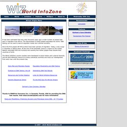
How We Share the World. This interactive graphic shows how the world is divided according to six different socioeconomic variables.
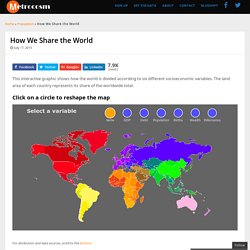
The land area of each country represents its share of the worldwide total. Click on a circle to reshape the map. World InfoZone - African Origins Menu. It has been estimated that only sixty thousand years ago a small number of people took part in migration from Africa.
The descendants of these people populated the world. DNA testing can be used to look at migration routes and common ancestry. Here's Everyone Who's Emigrated to the U.S. Since 1820. From 1820 to 2013, 79 million people obtained lawful permanent resident status in the United States.
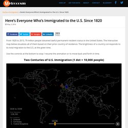
The interactive map below visualizes all of them based on their prior country of residence. The brightness of a country corresponds to its total migration to the U.S. at the given time. Use the controls at the bottom to stop / resume the animation or to move back and forth in time. Two Centuries of U.S. The world’s flags, in 7 charts. The graphics below categorize the flags of the world in fascinating ways — by color, age and design.
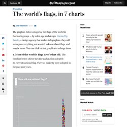
Created by Ferdio, a design agency that makes infographics, they will show you everything you wanted to know about flags, and maybe more. You can click on the graphics to enlarge them. Tech Tip: Digital storytelling with Google Map tools. You’ve done it.
Go ahead and admit it. You’ve searched for your house on Google Maps. In fact the first place you looked in Google Earth and Street View was your house. But Google Map tools are not just a consumption tool, they can be a powerful creation tool for students to tell stories — stories of history, literature, science, and social studies. The three main tools for map creation are Google Earth, Google Tour Builder, and Google My Maps. Larry Ferlazzo's Websites of the Day... - 7 new articles.
Five Most Popular Posts Of The Week Announcing “Question Week 2016″!
Warren Berger, author of “A More Beautiful Question” writes: It’s always a good time for asking questions, but now there’s an especially good time: the week of March 13 to 19, otherwise known as “Question Week 2016.” I am organizing this event in partnership with the Right Question Institute and other organizations that champion questioning. View from Above. 1.1 Population Dynamics. WORLD POPULATION PAST & PRESENT. The Best Online Geography Games. As regular readers know, in addition to teaching mainstream English classes and to Beginning and Intermediate English Language Learners, I also teach a Geography class to ELLs (as well as an IB Theory of Knowledge class).
I thought it might be useful to create a “The Best” list just focused on Geography games as a supplement to these other lists: The Best Websites For Learning & Teaching Geography The Best Geography Sites For Beginning & Intermediate English Language Learners. How classrooms look around the world — in 15 amazing photographs. To mark last month’s World Teachers’ Day (sponsored by UNESCO , the United Nations Educational, Scientific and Cultural Organization), photographers from Reuters took pictures around the world of educators with their students in a telling exhibit of the very different circumstances under which children attend school. Here are 15 pictures taken by Reuters photographers, revealing the spectrum of “classrooms” — from those with literally no resources to those well-stocked and housed.
Teacher Mahajera Armani and her class of girls pose for a picture at their study open area, founded by Bangladesh Rural Advancement Committee (BRAC), outside Jalalabad city, Afghanistan September 19, 2015. A Collection Of “Best” Lists Related To International Terrorism. In light of the terrorist attacks in Paris last night, I thought that teachers would find it useful for me to bring links to all my international terrorist-related “Best” lists together in one post: The Best Resources For Teaching & Learning About The Paris Attacks. #15Girls, NPR global health. The True Size of… A_good_read.pdf. New Resources On The World’s Different Cultures.
Native American Languages and Groups. Activities Index. This website would like to remind you: Your browser (Firefox 17) is out of date. Update your browser for more security, comfort and the best experience on this site. Xpeditions is now archived in National Geographic Education's new website—natgeoed.org.
Geo Quizzes & Games. CIA World Factbook. People from nearly every country share information with CIA, and new individuals contact us daily. If you have information you think might interest CIA due to our foreign intelligence collection mission, there are many ways to reach us. If you know of an imminent threat to a location inside the U.S., immediately contact your local law enforcement or FBI Field Office. For threats outside the U.S., contact CIA or go to a U.S. Latin America. Africa. Europe. Asia. Human Origins. Economics & Trade. Migration. Culture in the classroom. Religions. Global Competence.
Map Skills & Geographic Reasoning. Literacy & Non-Fiction Texts. Writing. Sense of Place & Geo Trivia. National Parks. Standards. 40 more maps that explain the world. Geography-Rich Classroom. World ancestry. Maps. Geo-Educator of the Week Series. Xpeditions is now archived in National Geographic Education's new website—natgeoed.org. GeographyHub. Geography. Collaboration Centre. EarthPulse, Maps, Global Trends, Human Impact. Globalization, the international exchange of goods, services, cultures, ideas, has brought increased wealth for many and transformed forever the way humans interact.