
Earthquake! Earthquakes. Plate tectonics. The tectonic plates of the world were mapped in the second half of the 20th century.
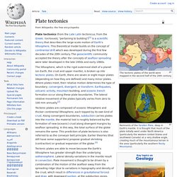
Remnants of the Farallon Plate, deep in Earth's mantle. It is thought that much of the plate initially went under North America (particularly the western United States and southwest Canada) at a very shallow angle, creating much of the mountainous terrain in the area (particularly the southern Rocky Mountains). Plate tectonics (from the Late Latin tectonicus, from the Greek: τεκτονικός "pertaining to building") is a scientific theory that describes the large-scale motion of Earth's lithosphere.
Geology.com - Earth Science News, Maps, Dictionary, Articles, Jobs. Welcome to the USGS - U.S. Geological Survey. Biogeography. Biogeography is the study of the distribution of species and ecosystems in geographic space and through geological time.
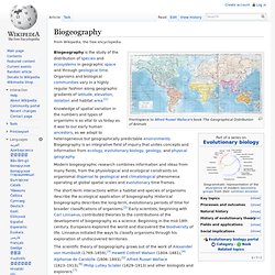
Organisms and biological communities vary in a highly regular fashion along geographic gradients of latitude, elevation, isolation and habitat area.[1] Knowledge of spatial variation in the numbers and types of organisms is as vital to us today as it was to our early human ancestors, as we adapt to heterogeneous but geographically predictable environments.
Biogeography is an integrative field of inquiry that unites concepts and information from ecology, evolutionary biology, geology, and physical geography. Modern biogeographic research combines information and ideas from many fields, from the physiological and ecological constraints on organismal dispersal to geological and climatological phenomena operating at global spatial scales and evolutionary time frames. Introduction[edit] U.S. Geological Survey Earthquake Hazards Program. Last earthquakes worldwide for the last 48 hours. ShakeAlert: California unveils plans for $80m earthquake early warning system. System will use 2,000 sensors already in place to look for 'p-waves', precursors to earthquakesWill provide 60 second warning, giving residents 'critical seconds' to prepareU.S.
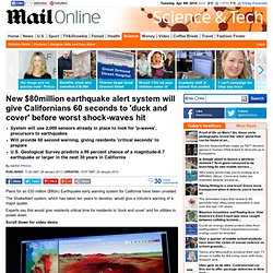
Geological Survey predicts a 99 percent chance of a magnitude-6.7 earthquake or larger in the next 30 years in California By Mark Prigg Published: 11:26 GMT, 29 January 2013 | Updated: 15:57 GMT, 29 January 2013 Plans for an £50 million ($80m) Earthquake early warning system for California have been unveiled. The ShakeAlert system, which has taken ten years to develop, would give a minute's warning of a major quake.
Experts say this would give residents critical time for residents to 'duck and cover' and for utilities to power down. Scroll down for video demo A simulation of a major earthquake along the an Andreas Fault, from the Salton Sea to downtown Los Angeles. The World’s Deadliest Earthquakes. The World’s Worst Earthquakes As measured by the death toll.

The worst earthquakes in history, in terms of the death toll have occurred in China. In addition to lying along the earthquake prone “ring of fire”, China also has historically had a high population density. This virtually ensure that the highest earthquake casualties will be in China. How does a seismograph work? What is the Richter scale?" A seismograph is the device that scientists use to measure earthquakes.

The goal of a seismograph is to accurately record the motion of the ground during a quake. If you live in a city, you may have noticed that buildings sometimes shake when a big truck or a subway train rolls by. Historic Events - Earthquakes. 2012 - Victoria - Moe This magnitude 5.4 earthquake occurred on 19 June 2012 at 8:53pm local time and was 10km southwest of Moe and 130km southeast of Melbourne.
Earthquake Safety Tips, Earthquake Preparation, Earthquake Readiness. Earthquakes are a common occurrence, rumbling below Earth's surface thousands of times every day.
But major earthquakes are less common. Here are some things to do to prepare for an earthquake and what to do once the ground starts shaking. Safety Tips. Newcastle City Council - Earthquake. At 10.27 am on Thursday, 28 December, 1989, the City of Newcastle was devastated by a ML 5.6 (Richter magnitude) earthquake.
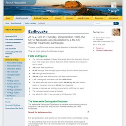
This was one of the most serious natural disasters in Australia's history. View our photo gallery of earthquake images. Facts and figures The earthquake claimed 13 lives. Nine people died at the Newcastle Workers Club; three people were killed in Beaumont Street, Hamilton and one person died of shock 160 people were hospitalised 50,000 buildings were damaged (approximately 40,000 of these were homes) 300 buildings were demolished 300,000 people were affected and 1,000 were made homeless It left a damage bill estimated to be about A$4 billion The effects were felt over an area of about 200,000 sq. km, with isolated reports of movement from up to 800 km from Newcastle Damage to buildings and facilities occurred within a 9000 sq. km region The earthquake epicentre was at Boolaroo One aftershock (M 2.1) was recorded on 29 December 1989.
Seismic Monitor. World's biggest earthquakes since 1900. Seismometer. Seismometers are instruments that measure motions of the ground, including those of seismic waves generated by earthquakes, volcanic eruptions, and other seismic sources.
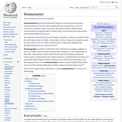
Records of seismic waves allow seismologists to map the interior of the Earth, and locate and measure the size of these different sources. The word derives from the Greek σεισμός, seismós, a shaking or quake, from the verb σείω, seíō, to shake; and μέτρον, métron, measure and was coined by David Milne-Home in 1841, to describe an instrument designed by Scottish physicist James David Forbes.[1] Seismograph is another Greek term from seismós and γράφω, gráphō, to draw. It is often used to mean seismometer, though it is more applicable to the older instruments in which the measuring and recording of ground motion were combined than to modern systems, in which these functions are separated. The concerning technical discipline is called seismometry,[3] a branch of seismology. Basic principles[edit] History[edit] Virtual Courseware : Earthquake : Epicenter and Magnitude.
How Earthquakes Work" Real-time Earthquake Map.