
Animate An Underground Map Without Keyframes In Motion 4. In this tutorial you will learn how to create and animate the map of your favorite city underground with Apple Motion 4.
Behaviours will be our friends to avoid the use of keyframes. They are one of the most powerful tools in Motion to speed up your work. Tutorial. Futuros Possíveis: arte, museus e arquivos digitais/Possible futures: art, museums and digital archives < Editora Peirópolis. The PhD in Intermedia Art, Writing and Performance. Mobile 3D Reality Capture System. 3D-ify Your World! City, Public Space and Mobile Technologies. Urban Augmented Reality and the Games of Cybergeography by Sam Kronick/ Ubicomputacional art: urban environment and emergent narratives by Tiago Rodrigues Lucena/ Augmenting Design Research: Investigating Public Space With Mobile Sensor Data by Ebru Kurbak, Mathias Mitteregger, Isabella Hinterleitner, and Sandrine von Klot/ Light Art in Public Space by Titia Ex/ Network culture, media art: urban identity and cultural change dialectics by Eva Kekou Dates: Monday, 19 September, 2011 - 17:00 - 18:40.
Browse By Author ID - Yuille, Jeremy - RMIT Research Repository. Leonardo Electronic Almanac / Volume 14, No. 3-4 / June-July 2006. EU Projects. A Small Love Story. Immersive storytelling. Nanna Verhoeff: Mobile Digital Cartography from Representation to Performance of Space. Nanna Verhoeff, associate professor in the department of Media and Culture studies at Utrecht University, had one of the very few yet very welcomed theoretical presentations in relation to the theme of the conference, urban screens.
Her contribution focused in particular on mobile screens (such as mobile phones, PDA’s and GPS devices), and their role in urban screen culture. She discussed the specificity of these screens in relation to the concept of mobility, an often encountered trope in the history of screen media. The first question which the speaker addressed was: how are these mobile screens different from the large digital displays in urban space? And, in relation to a broader range of screen media, how do mobile screens influence the relationship between the user, the screen and the space outside the screen? As Nanna Verhoeff points out, one of the differences between mobile screens and traditional static screens is the fact that mobile screens are ‘application based.’
Ponencias Congresos Arte y Sociedad. CONGRESOS INTERNACIONALES organizados y realizados por el grupo eumed●net de la Universidad de Málaga íntegramente a través de Internet SEGUNDO CONGRESO INTERNACIONAL SOBREArte y Sociedaddel 9 al 25 de octubre de 2012.
Building Complex Realities: Artistic Uses of Locative Media and Augmented Reality. Throughout the 20th century the artistic realm underwent a progressive transformation due to its increasing intersections with technology.
This caused a redefinition of the artistic object’s aesthetic basis and its relation with the spectator, but also meant the multiplication of genres and typologies linked to the new production, visualization and communication devices. However, in the last three decades and due to the Internet’s expansion, the aesthetic boundaries of art have rapidly extended beyond its limits thanks to a whole new set of technologies related to the Internet and based on different types of information processing which, every time more infiltrated within the socio-cultural environment, fluctuate between everyday uses and artistic applications.
Frammenti e appunti per un progetto nalla Laguna di Marano e Grado. Guidelines for authorsNECSUS. NECSUS accepts both solicited and unsolicited submissions for consideration on a rolling basis throughout the year in addition to book, festival, and exhibition reviews (see specific submission guidelines for the review section at the end of the page).
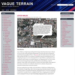
Prior to developing a complete manuscript authors are asked to submit an abstract (300 words max.) with short bio (100 words max.) and 3-5 key bibliographic sources to the editors, who will make a preliminary decision regarding the topic’s relevance to the journal’s aims and scope and will provide suggestions for developing the manuscript. Joyce Walks. Introduction Joyce Walks is a Google maps mashup which remaps routes from James Joyce's Ulysses to any city in the world, generating walking maps to be used as the basis of situationist inspired psychogeographical d?
Net Works: Case Studies in Web Art and Design: Amazon.co.uk: xtine burrough: Books. Conor McGarrigle: Texts. Interactive Multimedia Technology. MA Module at the University of Brighton MJM20. Urry and Elliot (2010) discuss a future scenario of the digital city which has used technology to respond to and combat the environmental issues brought about by human-induced global warming.
A techno-optimist view widely held by publics, scholars, corporations and governments alike. Authorised by a dominant discourse advocating reliance upon conceptions of evidence and proof, science and technology, rationality and objectivity, we have convinced ourselves a detachment from, and an intelligence, power and technological control over the environment, our surroundings and ourselves (Adams 1998). By extending our human powers through science and technology, through digital sensor monitoring, we believe we can address, undo, and reverse the environmental damage we continue to cause.
Space and Time in Ancient Greek Narrative - Alex C. Purves. Psychogeography: The Landscapes of Memory. Walkingstories-info.pdf. Walking Stories : Public Art for Dundrum. Listen to the Stories The stories are best experienced using the LAYAR App in the locations to which they refer but you can listen to them here or download them to a personal MP3 device which can be used in conjunction with the map.
Walking Stories : Public Art for Dundrum. Starting at the Carnegie Library the soundwalk unfolds in Dundrum village leading participants on a narrative trail which recounts the personal stories that connect people to specific locations.
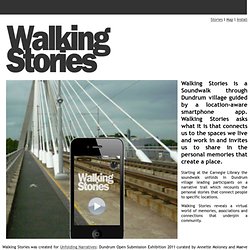
Walking Stories reveals a virtual world of memories, associations and connections that underpin a community. Walking Stories was created for Unfolding Narratives: Dundrum Open Submission Exhibition 2011 curated by Annette Moloney and Maeve Mulrennan and commissioned by Dún Laoghaire Rathdown County Council. Install Walking Stories on your phone, listen to the stories here, download the map, Conor McGarrigle : Art projects. Conor McGarrigle: Texts. Map Your Adventures With This Interactive Travel Visualizer. You can always track where in the world you’ve been with old school pins on a map board, but if you want a more sophisticated, digital version, there’s Visits, a program that turns your personal globetrotting history into a series of interactive online map-timelines.
It turns GPS data--usually an unsentimental batch of numbers--into a means of recording memories. V.isits.in is a research project by Alice Thudt, Dominkus Baur and professor Sheelagh Carpendale, at the University of Calgary, which aggregates geotags from your Flickr albums, data from OpenPath, and Google Location Histories to visualize where you've been and how long you stayed there. (The program runs locally on Visits' browser, so no private data is uploaded to their servers.) Qube OS.