Cumulonimbus cloud. Cumulonimbus, from the Latin cumulus ("heap") and nimbus ("rainstorm", "storm cloud"), is a dense towering vertical cloud associated with thunderstorms and atmospheric instability, forming from water vapor carried by powerful upward air currents.
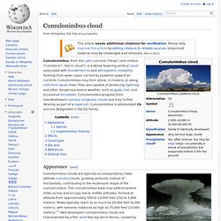
Cumulonimbus may form alone, in clusters, or along cold front squall lines. They are capable of producing lightning and other dangerous severe weather, such as gusts, hail, and occasional tornadoes. Cumulonimbus progress from overdeveloped cumulus congestus clouds and may further develop as part of a supercell. Cumulonimbus is abbreviated Cb and are designated in the D2 family. Appearance[edit] An exceptionally clearly developed single-cell Cumulonimbus incus Big displaying the classic anvil shape; associated gusts may occur from the direct proximity to several times the height of the cloud.
Cumulonimbus capillatus incus Species[edit] Cumulonimbus. Contrail. Sinuous vapor trail over south-east Poland.
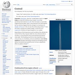
Depending on the temperature and humidity at the altitude the contrail forms, they may be visible for only a few seconds or minutes, or may persist for hours and spread to be several miles wide. The resulting cloud forms may resemble cirrus, cirrocumulus, or cirrostratus, and are sometimes called cirrus aviaticus. Persistent spreading contrails are thought by some, without overwhelming scientific proof, to have a significant effect on global climate.[2] Condensation from engine exhaust[edit] The main products of hydrocarbon fuel combustion are carbon dioxide and water vapor.
Cirrocumulus cloud. Cirrocumulus is one of the three main genus-types of high-altitude tropospheric clouds, which also includes cirrus and cirrostratus.[3] They usually occur at an altitude of 5 kilometres (16,000 ft) to 12 kilometres (39,000 ft).
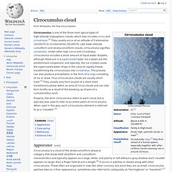
Like lower altitude cumuliform and stratocumuliform clouds, cirrocumulus signifies convection. Unlike other high cirrus and cirrostratus, cirrocumulus includes a small amount of liquid water droplets, although these are in a supercooled state. Polar stratospheric cloud. Polar stratospheric clouds or PSCs, also known as nacreous clouds (/ˈneɪkriːəs/, from nacre, or mother of pearl, due to its iridescence), are clouds in the winter polar stratosphere at altitudes of 15,000–25,000 meters (49,000–82,000 ft).
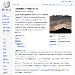
They are best observed during civil twilight when the sun is between 1 and 6 degrees below the horizon.[1] They are implicated in the formation of ozone holes.[2] The effects on ozone depletion arise because they support chemical reactions that produce active chlorine which catalyzes ozone destruction, and also because they remove gaseous nitric acid, perturbing nitrogen and chlorine cycles in a way which increases ozone destruction.[3] Formation[edit] The stratosphere is very dry; unlike the troposphere, it rarely allows clouds to form.
In the extreme cold of the polar winter, however, stratospheric clouds of different types may form, which are classified according to their physical state and chemical composition. Arcus cloud. Panorama of a strong shelf cloud, a type of arcus cloud Underside of a weak shelf cloud An arcus cloud is a low, horizontal cloud formation.
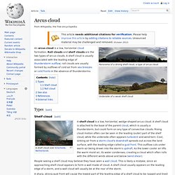
Roll clouds and shelf clouds are the two types of arcus clouds. A shelf cloud is usually associated with the leading edge of thunderstorm outflow; roll clouds are usually formed by outflows of cold air from sea breezes or cold fronts in the absence of thunderstorms. Noctilucent cloud. Night clouds or noctilucent clouds are tenuous cloud-like phenomena that are the "ragged edge" of a much brighter and pervasive polar cloud layer called polar mesospheric clouds in the upper atmosphere, visible in a deep twilight.
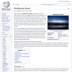
They are made of crystals of water ice. Noctilucent roughly means night shining in Latin. They are most commonly observed in the summer months at latitudes between 50° and 70° north and south of the equator. They can only be observed when the Sun is below the horizon. They are the highest clouds in Earth's atmosphere, located in the mesosphere at altitudes of around 76 to 85 kilometres (47 to 53 mi). Noctilucent clouds can form only under very restrictive conditions; their occurrence can be used as a sensitive guide to changes in the upper atmosphere. Mammatus cloud. Mammatus, also known as mammatocumulus (meaning "mammary cloud"),[1][2] is a meteorological term applied to a cellular pattern of pouches hanging underneath the base of a cloud.
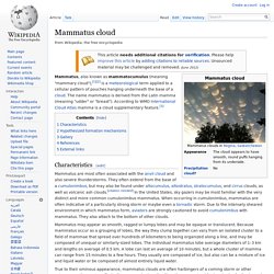
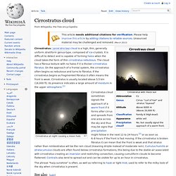
The name mammatus is derived from the Latin mamma (meaning "udder" or "breast"). Incredible & Crazy Sky in Upper Michigan! HD. Undulatus asperatus. Cirrostratus cloud. Cirrostratus at night causing a moon halo The phrase "hazy sunshine" is often, as well as referring to haze or light mist, used to refer to the milky look of the sky when cirrostratus is present.
See also[edit] References[edit] External links[edit] Halo (optical phenomenon) A halo around the sun in Padang, Indonesia A halo (from Greek ἅλως, halōs;[1] also known as a nimbus, icebow or gloriole) is an optical phenomenon produced by ice crystals creating colored or white arcs and spots in the sky.
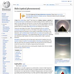
Many are near the sun or moon but others are elsewhere and even in the opposite part of the sky. They can also form around artificial lights in very cold weather when ice crystals called diamond dust are floating in the nearby air. Atmospheric phenomena such as halos were used as part of weather lore as an empirical means of weather forecasting before meteorology was developed. They often do mean that rain is going to fall within the next 24 hours as the cirrostratus clouds that cause them can signify an approaching frontal system.