
The Water Cycle for Kids and Students. The water cycle describes how Earth's water is not only always changing forms, between liquid (rain), solid (ice), and gas (vapor), but also moving on, above, and in the Earth.
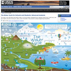
This process is always happening everywhere. Teacher Resources: Water Science School. USGS Home Contact USGS Search USGS The USGS Water Science School Teacher Resources for Water Science, USGS The Water Cycle We have a water-cycle for schools section with a diagram and an online, interactive version aimed at three age-levels of students.
Files for printing: PDF (2 Mb poster) | Image (11x17 inch) | Image (poster) Water Properties Learn about what makes water unique and vital to all life on Earth. The Story of Dryville! Story of YOU going into the desert to start a new town...and how water plays a part every step of the way. Activity Center. Extreme Weather on Our Planet. 1.
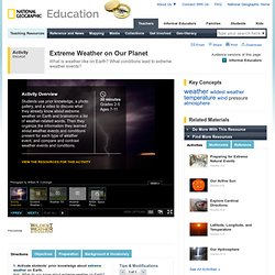
Activate students’ prior knowledge about extreme weather on Earth.Ask: What do you know about extreme weather on Earth? Encourage students to think about weather they have experienced, read about, or seen on TV or in the movies. Have students brainstorm a list of weather-related words and phrases as they “pass the marker.” Start the process by writing one weather-related word on the board. Distribute three dry-erase markers to volunteers with ideas. Wind. Wind is the movement of air caused by the uneven heating of the Earth by the sun.

It does not have much substance—you cannot see it or hold it—but you can feel its force. It can dry your clothes in summer and chill you to the bone in winter. It is strong enough to carry sailing ships across the ocean and rip huge trees from the ground. It is the great equalizer of the atmosphere, transporting heat, moisture, pollutants, and dust great distances around the globe. Landforms, processes, and impacts of wind are called Aeolian landforms, processes, and impacts. Differences in atmospheric pressure generate winds. The boundary between these two areas is called a front. Prevailing winds are winds that blow from a single direction over a specific area of the Earth. The Coriolis effect causes some winds to travel along the edges of the high-pressure and low-pressure systems. Wind Zones Polar EasterliesPolar easterlies are dry, cold prevailing winds that blow from the east.
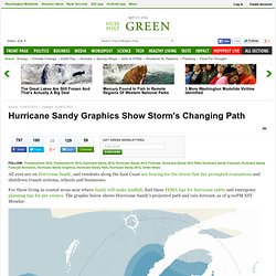
Results of Wind. Sandy's Hook: How Unusual Is This? Sandy Computer Model Tracks Typical Late-Season Track: "Recurve" Next Plotted above are the latest computer model forecast plots for Sandy.
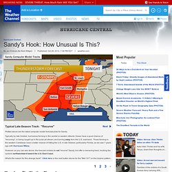
Typically by late October, hurricanes forming in the central or western Atlantic Ocean have a good chance of "recurving", or being caught up in the polar jet stream, and turning away from the U.S. mainland. Those forming in the western Caribbean have a better chance of hitting the U.S. in late October, particularly Florida, as we saw 7 years ago with Hurricane Wilma. The Complete Story of Sandy: a Timeline of Horror and Recovery. Hurricane Sandy Graphics Show Storm's Changing Path.
Seaside Heights, N.J.John Okeefe walks on the beach as a rollercoaster that once sat on the Funtown Pier in Seaside Heights, N.J., rests in the ocean on Wednesday, Oct. 31, 2012 after the pier was washed away by superstorm Sandy which made landfall Monday evening.
Ocean City, M.D.A National Guard humvee travels through high water to check the area after the effects of Hurricane Sandy Tuesday, Oct. 30, 2012, in Ocean City, Md. Sandy, the storm that made landfall Monday, caused multiple fatalities, halted mass transit and cut power to more than 6 million homes and businesses. (Alex Brandon, AP)Lower ManhattanWater is pumped on to the street in lower Manhattan in New York, U.S., on Thursday, Nov. 1, 2012. The New York region is replacing a rail network built over a century with a patchwork constructed day-by-day to move its 8 million people again as it struggles back to life after Hurricane Sandy. National Maps. NOAA Education Resources Website.
Weather Questions and Answers. What are cold fronts and warm fronts? Fronts are the boundaries between air masses of different temperature.
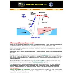
If warm air is moving toward cold air, it is a “warm front”. These are shown on weather maps as a red line with scallops on it. If cold air is moving toward warm air, then it is a “cold front”. Cold fronts are always shown as a blue line with arrow points on it. If neither air mass is moving very much, it is called a “stationary front”, shown as an alternating red and blue line. Usually, a cold front will be associated with a warm front, with a low pressure center, connecting them (see above). Most of Earth's disturbed weather (widespread cloud and precipitation systems) outside of the deep tropics occurs along or near fronts as part of extratropical cyclone systems.