
Mark Stronge's UK Weather Portal. All the best of marine forecasts for the UK, mainland Europe as well as GRIB files available for anywhere in the world.
High Seas Metarea 1 High Seas Metarea 2 GMDSS World Shipping Live European Navtex Storm Warnings Listen to the BBC Shipping Forecast BBC Sea and Coastal Waters Metcheck Inshore Forecast Met.Office Inshore Waters – Printable Met.Eireann Inshore Waters WeatherWeb Sailing Forecasts Windfinder. Sailing weather forecasts. Kart. Kart. Mark Stronge's UK Weather Portal. Meteosat 0 degree Eview SEGMENT4. Mark Stronge's UK Weather Portal. Visible, Infra-red, and RADAR satellite images of Europe and the British Isles and Solar images BBC Infrared Satellite Sat24 European animated Mobile– iPhone EUMETSAT RGB Near realtime UK images MeteoSat European Rain Today WeatherCast 15 minute RADAR Met.
Meteox UK and European Radar Workingham Weather HRPT imagery SOHO solar imagery SOHO latest movies SOHO MDI Farside of the Sun SOHO MDI Farside Animation Check out more solar data on our Space Weather page. Mark Stronge's UK Weather Portal. Latest weather reports from public and private weather stations, Live lightning data and storm predictions Met.Office current observations – Mobile.
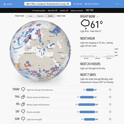
Mark Stronge's UK Weather Portal. Forecast. ●Nagpur●Kiev●Jiddah●Rome●Dakar●Nairobi●Addis Ababa●Umm Durman●Madrid●Riyadh●Casablanca●Baghdad●London●Cairo●Kinshasa●Lagos●Istanbul●Moscow●New Delhi●Bombay 9 Click to load animation Light Rain · Feels like 61°
Mark Stronge's UK Weather Portal. Short range and 14 day long range general forecasts for the UK and Ireland.
Metcheck – Mobile Forecast.co.uk. Terms. Is taken from the synoptic chart of the weather probabilities in your area.
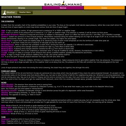
The lines on the synoptic chart denote equal pressure, rather like a sea chart where the lines are lines of equal depths or a land map where contour lines are lines of equal height. High: A high is a peak, or centre, of high pressure and is marked as 'H' or 'HIGH' on weather maps.Low: A low is a centre of low pressure and is marked as 'L' or 'LOW' on weather maps. If its direction is marked, it will be shown as thick arrow.Barometric Pressure: Pressure is measured and shown in millibars or Hectopascal, which is in effect the same (one mb = one HPa). 1013 mb/HPa is average.Isobars: Isobars are contours or lines of equal pressure.
Wind follows clockwise along the isobars blowing out of a high at an angle of 20° or so. In lows the wind follows anticlockwise, blowing in at a similar angle. 997, 976 and 1008: These are millibars; 997mbs is a measure of air pressure. Sky. READING THE SKYClouds consist of droplets of water (ice or snow) in suspension.

The warmer the air the greater capacity to carry moisture. If the temperature falls or too much moisture is fed into a cloud, it sheds in the form of rain, hail or snow (i.e. precipitation). Cirrus is feathery, either white or transparent, but can just obscure the sun. The stratus family is like a fog and can be associated with drizzle. Sky. Milford Haven. Nat Radio UK. Wind forecast map worldwide. Description This is the wind, wave and weather forecast map for worldwide.
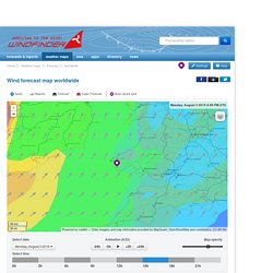
Windfinder specializes in wind, waves, tides and weather reports & forecasts for wind related sports like kitesurfing, windsurfing, surfing, sailing or paragliding. On the wind forecast map for worldwide, the predicted wind direction is represented by arrows, the wind speed is indicated with colours. The arrows point in the direction that the wind is blowing. The Forecast is based on the GFS model. Check the wind and weather forecast for worldwide for the next 7 days by using the animation control below the wind forecast map.
Units Our default units are knots and degrees Celsius. Help If you need more information about our wind forecast map for worldwide, have a look at our help section. Weather Superforecast Milford Haven/Steynton. Description This is the wind, wave and weather Superforecast for Milford Haven/Steynton in Wales, United Kingdom.
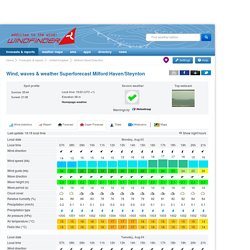
Windfinder specializes in wind, waves, tides and weather reports & forecasts for wind related sports like kitesurfing, windsurfing, surfing, sailing or paragliding. The Superforecast is based on the newest versions of high resolution weather prediction models. Highest & lowest predicted tides at Fishguard. National Tidal and Sea Level Facility. National Tidal and Sea Level Facility. British Oceanographic Data Centre (BODC) — oceanographic and marine data. Tides. Tides. United States - Maui (north shore)
PassageWeather - Sailing Weather - Marine Weather Forecasts for Sailors and Adventurers. Using PassageWeather with a low-bandwidth internet connection When using a low-bandwidth internet connection (such as Iridium, Globalstar, Thuraya, Inmarsat, etc.), it is not practical to access PassageWeather.com (or many other websites) in the normal way.
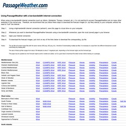
Therefore, we recommend that you follow these steps to download the forecast images (in .zip files) directly to your computer, without the need to "surf" the internet: To go to the PassageWeather.com website, click here Copyright © 2015 PassageWeather.com. Sailing Weather - Marine Weather Forecasts for Sailors and Adventurers - PassageWeather.