
Geology.com - Earth Science News, Maps, Dictionary, Articles, Jobs. US Map Collections for All 50 States. World Maps: Political, Physical, Satellite, Africa, Asia, Europe. Definitions - Geological Dictionary - Earth Science. Dictionary - Facies, Felsic, Fumarole. Dictionary - Expansive Clay - Expansive Soils. Dictionary - Diatomite, Drawdown, Drumlin. Dictionary - Cirque, Chert, Clastic. Dictionary - Basalt - Batholith - Butte. Dictionary - Alluvial, Aquiclude, Arkose. Classified Ads: Minerals, Rocks, Maps, Tools and More.
Tools, Supplies, Equipment and Books. Waterproof Cases and Bags for Cameras, Phones and Gear. Rock, Mineral & Fossil Kits and Collections. Waterproof Paper for Laser Printers, Inkjet and Copiers. Earth Science Articles. Graduate Study in Geology - Graduate Student Life - Geology.com. So, you just arrived for your first day of Geology grad school.
Welcome to the next 2-10 years of your life! Your program may be a major research department with 40 faculty members, or a small liberal arts schools with a little-used MS degree. You may be sitting on the beach in California or surrounded by corn fields in the Midwest. Alternatively, you may be a Geology senior wondering what to do next year, or a 7th-year PhD student trying to figure out where things went wrong. Either way, hearing how others have navigated the graduate student experience may help you maximize the educational, scientific, and life opportunities now open to you.
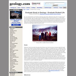
Soggy grad students - Coastal Geomorphology class trip, Spring, 2004 - Southern Illinois University Goals Where do I want to be when this grad-school thing is over (and how long is it going to take me to get there!)? Speaking of industry or academia, it's never too early to be asking yourself what kind of a career you have in mind. Milestones. Field Camp - Field Courses by 80+ Schools. Geologist Salaries and the Economic Slowdown. It's Still a Good Time to Be a Geologist!
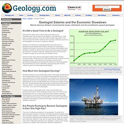
Although the news is full of stories about recession and unemployment, the demand for geologists is stronger than in most other business sectors. There have been layoffs, especially in the mineral resources sector, however, the long-term outlook is good and will strengthen as economic conditions improve. Salaries and demand for geologists often mirror the price of geological commodities such as fuels, metals and construction materials. At present, low prices for some of these commodities have resulted in layoffs. However those same low prices support demand. There are also many jobs for geologists outside of the mineral resource sector. How Much Are Geologists Earning? What is Geology? - What does a Geologist do? - Geology.com. Definition of Geology: Geology is the study of the Earth, the materials of which it is made, the structure of those materials, and the processes acting upon them.
It includes the study of organisms that have inhabited our planet. An important part of geology is the study of how Earth’s materials, structures, processes and organisms have changed over time. What Does a Geologist Do? Geologists work to understand the history of our planet. Geologist Salary News. Washington Geology. Washington State Map - Cities, Roads, Counties, Rivers, Lakes, Topo. Welcome to the USGS - U.S. Geological Survey.
About USGS. About USGS The USGS is a science organization that provides impartial information on the health of our ecosystems and environment, the natural hazards that threaten us, the natural resources we rely on, the impacts of climate and land-use change, and the core science systems that help us provide timely, relevant, and useable information.
Mission. Employment Home Page. Travis Gibson Hydrological Technician “Working as a student for the USGS is an excellent way for anybody interested in working in a science field to “get their foot in the door“”
U.S. Geological Survey: Natural Hazards. Every year in the United States, natural hazard events threaten lives and livelihoods, resulting in deaths and billions of dollars in damage.
The USGS works with many partners to monitor, assess, and conduct targeted research on a wide range of natural hazards so that policymakers and the public have the understanding they need to enhance preparedness, response and resilience. In 2010, the USGS realigned its organizational structure around the missions identified in the USGS Science Strategy.
Volcano Hazards Program. Earthquakes. Global Seismographic Network. Geology Discipline - Home. U.S. Geological Survey: Social Media at the USGS. Maps, Imagery, and Publications. Geology. Geology gives insight into the history of the Earth by providing the primary evidence for plate tectonics, the evolutionary history of life, and past climates.
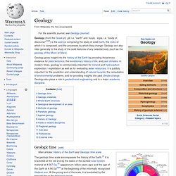
In modern times, geology is commercially important for mineral and hydrocarbon exploration / exploitation as well as for evaluating water resources. It is publicly important for the prediction and understanding of natural hazards, the remediation of environmental problems, and for providing insights into past climate change. Geologic time scale. The geologic time scale (GTS) is a system of chronological measurement that relates stratigraphy to time, and is used by geologists, paleontologists, and other earth scientists to describe the timing and relationships between events that have occurred throughout Earth's history.
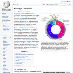
The table of geologic time spans presented here agrees with the nomenclature, dates and standard color codes set forth by the International Commission on Stratigraphy. Evidence from radiometric dating indicates that the Earth is about 4.54 billion years old. The geology or deep time of Earth's past has been organized into various units according to events which took place in each period.
Different spans of time on the GTS are usually delimited by changes in the composition of strata which correspond to them, indicating major geological or paleontological events, such as mass extinctions. Terminology[edit] Rock (geology) Rocks have been used by mankind throughout history.
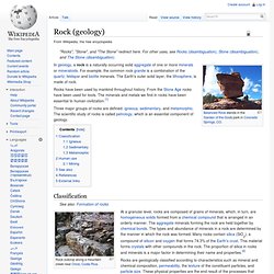
From the Stone Age rocks have been used for tools. The minerals and metals we find in rocks have been essential to human civilization.[1] Three major groups of rocks are defined: igneous, sedimentary, and metamorphic. Rock cycle. Historical development[edit] The original concept of the rock cycle is usually attributed to James Hutton, from the eighteenth century Father of Geology.
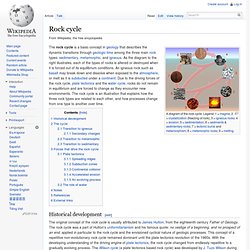
The rock cycle was a part of Hutton's uniformitarianism and his famous quote: no vestige of a beginning, and no prospect of an end, applied in particular to the rock cycle and the envisioned cyclical nature of geologic processes. This concept of a repetitive non-evolutionary rock cycle remained dominant until the plate tectonics revolution of the 1960s. With the developing understanding of the driving engine of plate tectonics, the rock cycle changed from endlessly repetitive to a gradually evolving process.
The Wilson cycle (a plate tectonics based rock cycle) was developed by J. The cycle[edit] Transition to igneous[edit] When rocks are pushed deep under the Earth's surface, they may melt into magma. Secondary changes[edit] [edit] Transition to sedimentary[edit] Forces that drive the rock cycle[edit] Plate tectonics[edit] In 1967, J. Igneous rock. Geological significance[edit] Igneous and metamorphic rocks make up 90–95% of the top 16 km of the Earth's crust by volume.[1] Igneous rocks are geologically important because: their minerals and global chemistry give information about the composition of the mantle, from which some igneous rocks are extracted, and the temperature and pressure conditions that allowed this extraction, and/or of other pre-existing rock that melted;their absolute ages can be obtained from various forms of radiometric dating and thus can be compared to adjacent geological strata, allowing a time sequence of events;their features are usually characteristic of a specific tectonic environment, allowing tectonic reconstitutions (see plate tectonics);in some special circumstances they host important mineral deposits (ores): for example, tungsten, tin, and uranium are commonly associated with granites and diorites, whereas ores of chromium and platinum are commonly associated with gabbros.
Intrusive[edit] Sedimentary rock. Middle Triassic marginal marine sequence of siltstones (below) and limestones (above), Virgin Formation, southwestern Utah, USA Genetic classification Based on the processes responsible for their formation, sedimentary rocks can be subdivided into four groups: clastic sedimentary rocks, biochemical (or biogenic) sedimentary rocks, chemical sedimentary rocks and a fourth category for "other" sedimentary rocks formed by impacts, volcanism, and other minor processes. Clastic sedimentary rocks Main article: Clastic rock Clastic sedimentary rocks are composed of silicate minerals and rock fragments that were transported by moving fluids (as bed load, suspended load, or by sediment gravity flows) and were deposited when these fluids came to rest. Metamorphic rock. Metamorphic minerals are those that form only at the high temperatures and pressures associated with the process of metamorphism.
These minerals, known as index minerals, include sillimanite, kyanite, staurolite, andalusite, and some garnet. Other minerals, such as olivines, pyroxenes, amphiboles, micas, feldspars, and quartz, may be found in metamorphic rocks, but are not necessarily the result of the process of metamorphism. These minerals formed during the crystallization of igneous rocks. They are stable at high temperatures and pressures and may remain chemically unchanged during the metamorphic process. However, all minerals are stable only within certain limits, and the presence of some minerals in metamorphic rocks indicates the approximate temperatures and pressures at which they formed.
Plate tectonics. The tectonic plates of the world were mapped in the second half of the 20th century. Remnants of the Farallon Plate, deep in Earth's mantle. It is thought that much of the plate initially went under North America (particularly the western United States and southwest Canada) at a very shallow angle, creating much of the mountainous terrain in the area (particularly the southern Rocky Mountains).
Plate tectonics (from the Late Latin tectonicus, from the Greek: τεκτονικός "pertaining to building") is a scientific theory that describes the large-scale motion of Earth's lithosphere. This theoretical model builds on the concept of continental drift which was developed during the first few decades of the 20th century. The geoscientific community accepted the theory after the concepts of seafloor spreading were later developed in the late 1950s and early 1960s. Structure of the Earth. Structure of the Earth Assumptions[edit] The force exerted by Earth's gravity can be used to calculate its mass, and by estimating the volume of the Earth, its average density can be calculated.
Astronomers can also calculate Earth's mass from its orbit and effects on nearby planetary bodies. Structure[edit] Geology Labs On-Line. Electronic Desktop Project - Virtual Earthquake. Virtual River. Welcome to Virtual Age - Dating. GLOL Credits.