
Coetzerjan : Folding in an amphibolite outcrop ... Course: Distance Learning (taster) StrucGeology. Structural Geology by the Deformation numbers. Structural geologists seek to understand how rocks have changed shape, in order to better understand wider processes such as how mountains are formed.
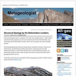
Sometimes they use a terminology called ‘Deformation-numbers’ which I will now explain via a series of pretty pictures. Structural geologists spend their day measuring the orientations of things. These can be planar things, like sedimentary bedding, fault planes, cleavage planes and other metamorphic fabrics; or linear things like fold axes or mineral stretching lineations. All these things interact in various ways, but given time and a compass-clinometer a good geologist will work it all out. The trouble is that rocks are complicated. It’s clear that there is tight folding in metamorphosed sediments. But, as so often in field geology, a closer look from the same area reveals a more complicated picture. There is a clear set of folding – the obvious wavy pattern of the dark and light layers. An Irish example Wider implications Careful now! 2013 May 19 - Earths Richat Structure.
Discover the cosmos!
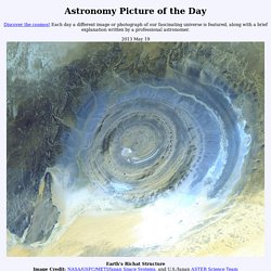
Each day a different image or photograph of our fascinating universe is featured, along with a brief explanation written by a professional astronomer. 2013 May 19 Explanation: What on Earth is that? The Richat Structure in the Sahara Desert of Mauritania is easily visible from space because it is nearly 50 kilometers across. Once thought to be an impact crater, the Richat Structure's flat middle and lack of shock-altered rock indicates otherwise. Earthquake clustering, complex fault ruptures, and the geologic record. By M.
C. Quigley Mark C. Quigley is a Senior Lecturer in Active Tectonics at the University of Canterbury in Christchurch, New Zealand. He is the recipient of the 2011 Prime Minister’s Prize for Science Communication and 2013 Geological Society of New Zealand Hochstetter Lecturer. The last decade has perhaps been the worst ever for both earthquake scientists and earthquake victims. The 2011 Mw 9.0 Tohuku earthquake greatly exceeded previous scientific estimates of Mw potential1 (Mwmax ~7.7 to 8.5) and killed 20,000 in its tsunamogenic aftermath, prompting a rethink of whether the relatively short timeframe captured by historical and instrumental data really enables us to understand the earthquake potential of specific segments of subduction zones.
This essay focuses on the last issue, and asks two questions (1) How can we better constrain the behaviour and Mw potential of complicated fault systems using the oft incomplete geologic records of faulting? When did Plate Tectonics begin on Earth, and what came before? By Robert J.

Stern Two of my favorite topics of geoconversation are how new subduction zones get started and when in Earth’s history did plate tectonics begin? Both are fascinating geoscientific questions but we seem to be making more progress on the first topic than on the second. Structural Geology. Structural Geology Techniques. Journal of Structural Geology. Journal of Structural Geology - Shear zone geometry: A review. Section II: Kinematics and mechanics J.G.

Ramsay Geologisches Institut, ETH, CH-8092 Zürich, Switzerland Received 26 June 1979, Accepted 26 September 1979, Available online 27 March 2003 Choose an option to locate/access this article: Check if you have access through your login credentials or your institution Check access Show more Show less Get rights and content Shear zones may be classified into brittle, brittle-ductile, and ductile shear zones. Shear zones commonly occur in conjugate sets, but the two differently oriented sets do not seem to be able to operate synchronously. The termination of all types of shear zones poses complex compatibility problems, some solutions are suggested. A synthesis of shear zone geometry in regions of crustal contraction and crustal extensions is made, and ideas on how deep level ductile shear zones relate to high level brittle shears and gliding nappes are put forward.
Visit to the Ries impact crater in Germany. You may have seen the recent news about the near-Earth flyby of a 2.7 km asteroid.

Fortunately the rock missed collision with the Earth, and continued its journey around the Solar System. However, in the past Earth has not been so lucky. Asteroid and comet collisions have shaped the surface of the Earth throughout the past 4.5 billion years ago. The scars of these cataclysmic events have often been eroded by active geological processes. One such event occurred in southern Germany ~14.5 million years ago, when a projectile 1.5 km in diameter slammed into the Earth.
Looking from the rim of the Steinheim impact crater towards the central peak, which was uplifted into a hill during the impact cratering event (Image K.Joy) SEAES students inspect an overturned megablock of limestone on the Ries crater rim (Image K. Both are the unique places on Earth to study the products of impact cratering, and some of the Apollo astronauts even trained here prior to their missions to the Moon. Like this: