
National Remote Sensing Centre. An Open Access Journal from MDPI. Disaster Charter - Examples of Charter satellite imagery. What is the best band combination for highlighting the water and soil together in LANDSAT image? A canonical Although, the extra bands in L8 OLI require some elementary consideration.

Bands 5-4-3 I would suggest you to have a look on this link... 4,5,3 : This combination of near-IR (Band 4), mid-IR (Band 5) and red (Band 3) offers added definition of land-water boundaries and highlights subtle details not readily apparent in the visible bands alone. Inland lakes and streams can be located with greater precision when more infrared bands are used.
TM band combination of 542 or 643 will have a good land delination as well as water. Sentinel-2 / Copernicus / Observing the Earth. Winter Storm Stalls Thanksgiving Travel. As millions of Americans are taking to the highways for the Thanksgiving holiday, a powerful winter storm is plowing across the nation.
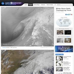
The storm is leaving snow, ice, and rain in its wake, creating hazardous travel conditions. By the time the storm is over, it will have brought wintery weather to 2.5 million square miles of the United States. The storm is big news because it is disrupting travel during one of the busiest travel period of the year, but it's not otherwise all that unusual, says NASA research scientist Chris Kidd. “Large storms are expected a few times each winter, particularly at this time of the year,” says Kidd. Ocean waters in the Gulf of Mexico are still warm—around 80 degrees Fahrenheit—and they load the atmosphere with moisture. These images and animations show the storm system between November 24 and 26, 2013. Giovanni - TRMM L-3 V6 and V7 Inter-comparison. Indira Gandhiweg, Suriname.
LearnEO!: Resources for Earth Observation education. National Geologic Map Database. Background Geologic Map Symbolization FGDC standard:Formal document, in PDF format (with guidance and background documentation)Postscript implementation of the FGDC standardESRI implementation, in "Geologic Mapping Template"Ask about other implementations planned Development and public review of the FGDC standard FGDC standard for describing scientific and locational accuracy of geologic features background information, for the FGDC standard Geologic Time ScalesUSGS Divisions of Geologic Time (2010 revision)International Commission on Stratigraphy ( in Commission for the Geological Map of the World color scheme (about 700KB) Geologic Map Database SCIENCE TERMINOLOGIES -- NCGMP09 vocabularies CGI Geoscience Concept Definitions working group SLTT -- Report on progress to develop a North American Science-Language Standard for digital geologic-map databases (includes all NADM SLTT reports listed separately below): Appendix A.
Map Publication Guidelines Digital Mapping Techniques Metadata. Geology Discipline - Data. Software. USGS Mineral Resources On-Line Spatial Data. EU satellite data to be freely available. Copernicus already gathers and processes data from satellites.

In the future it will expand to include six dedicated satellite missions, called Sentinels, to be launched from 2014 onwards. It is hoped that the freely available data will help further environmental understanding, allowing businesses, researchers, citizens and policy makers to integrate greater environmental knowledge into everything they do. The European Environment Agency (EEA) plays a key role in Copernicus, coordinating in-situ observations and contributing to the development of services, with a particular focus on the technical coordination of the Land Monitoring Service.
The data is useful for many different users. Geology Discipline - Data. TRMM. Download ERDAS IMAGINE 2013 (includes LPS) ERDAS IMAGINE 2013 (including LPS) is the full released product that includes all three tiers of ERDAS IMAGINE 2013, LPS 2013, and most associated add-ons.
This installer does not include ERDAS ER Mapper 2013. This installer does not include the following ERDAS IMAGINE add-ons: ATCOR, IMAGINE Toolkit, and IMAGINE Defense Productivity Module. This installer does not include the following LPS add-ons: ORIMA and PRO600. For download information about the above products, please reference the Intergraph Product Download Portal webpage, or the product description webpages. Remote Sensing Tutorial Overview. Also of value are these Periodicals devoted largely to remote sensing methods and applications: To expand upon the remarks at the beginning of the Overview, the primary purpose of this Tutorial is to be a learning resource for college students, as well as for individuals now in the work force who require indoctrination in the basics of space-centered remote sensing.
In both instances the objective is to offer a background that will actually be useful in current or eventual job performance to those who may need to provide input information obtainable from remote sensing into day-to-day operations. We also think the Tutorial can be an invaluable resource for pre-college (mostly Secondary School) teachers who want to build a background in the essential contributions of the space program to society so as to better teach their students (many of whom should also be capable of working through the main ideas in the Tutorial). Foreword Section: 1. 2. 3. 4. 5. 6. 7. 8. Resolution in remote sensing terms. It is important to understand how a remote sensing tool operates in order to appreciate its ability to detect features - such as habitats - on the seabed (in intertidal or subtidal areas).
There are many excellent texts and websites explaining all the technical aspects of remote sensing; for example Green et al., describe the use of satellite and airborne remote sensors for marine mapping in tropical waters. The following text is based on information available on the US NASA website with some definitions taken from Wikipedia. 2 - An overview of spatial adjustment. Remote Sensing. Remote Sensing and Image Interpretation. Band combinations. Spectral Characteristics Viewer. In geological mapping and prospecting for mineral resources, is there any advantages of ASTER images over Landsat images? Band Combinations.
Landsat Thematic Mapper (TM) Band 1 (0.45 - 0.52u m): provides increased penetration of water bodies and also capable of differentiating soil and rock surfaces from vegetation and for detecting cultural features.
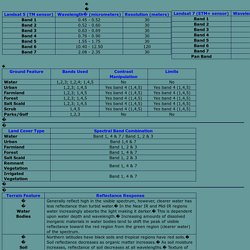
Band 2 (0.52 - 0.60u m): it is sensitive to water turbidity differences; it highlighted the turbid water in the Barkley Lake. Because it covers the green reflectance peak from leaf surfaces, it has separated vegetation (forest, croplands with standing crops) from soil. In this band barren lands urban areas and roads and highways have appeared as brighter (lighter) tone, but forest, vegetation, bare croplands, croplands with standing crops have appeared as dark (black) tone.
Also the Kentucky Lake has appeared as black tone. Band 3 (0.63 - 0.69u m): senses in a strong chlorophyll absorption region and strong reflectance region for most soils. Band 4 (0.76 - 0.90u m): operates in the best spectral region to distinguish vegetation varieties and conditions. Remote Sensing Tutorial Table of Contents. Remote Sensing Glossary. Research Paper Format. Polar orbits - What do satellites do? - Satellites & rockets - Solar spacecraft - Sun. Educational Activities « Landsat Science. NASA Wavelength is your pathway into a digital collection of Earth and space science resources for educators of all levels – from elementary to college, to out-of-school programs.
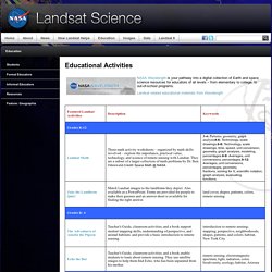
Landsat related educational materials from Wavelength Additional NASA Education Resources The Space Place The Space Place is a multi-faceted NASA outreach program. It creates unique educational products in a variety of media for a broad range of audiences. The Globe Program The Globe Program is an exciting, worldwide hands-on, primary and secondary school-based education and science program. Earth Science For Kids Only See how NASA studies air, land, natural hazards and water and how people affect the Earth.
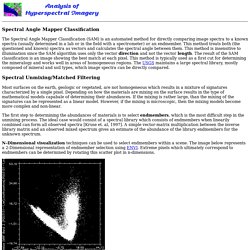
Earthscience@nasa This website elaborates on the purpose of NASA’s Earth science program. Downloads - ILWIS 3.08.03 - 52°North Initiative for Geospatial Open Source Software GmbH. Untitled. Spectral Angle Mapper Classification The Spectral Angle Mapper Classification (SAM) is an automated method for directly comparing image spectra to a known spectra (usually determined in a lab or in the field with a spectrometer) or an endmember.
Copernicus, the European EO Programme. NDVI Arcmap. the value of pixels.