
Overview.
Atlantic Ocean (1419–1507) Indian Ocean (1497–1513) Pacific Ocean (1513–1529) Inland Spanish conquistadores (1519–1532) New trade routes (1542–1565) Northern European involvement (1595 – 17th century) Russian exploration of Siberia (1581–1660) Global impact. Age of Discovery. Silk Road. Silk Road extending from Europe through Egypt, Somalia, the Arabian Peninsula, Iran, Afghanistan, Central Asia, Sri Lanka, Pakistan, India, Bangladesh, Burma, Java-Indonesia, Philippines and Vietnam until it reaches China.
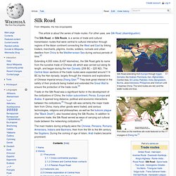
The land routes are red, and the water routes are blue. Port cities on the maritime silk route featured on the voyages of Zheng He.[1] The Silk Road, or Silk Route, is a series of trade and cultural transmission routes that were central to cultural interaction through regions of the Asian continent connecting the West and East by linking traders, merchants, pilgrims, monks, soldiers, nomads and urban dwellers from China to the Mediterranean Sea during various periods of time.[2] Extending 4,000 miles (6,437 kilometres), the Silk Road gets its name from the lucrative trade of Chinese silk which was carried out along its length, and began during the Han Dynasty (206 BC – 220 AD).
Name[edit] History[edit] Precursors[edit] Cross-continental journeys[edit] Hellenistic era[edit] Northwest Passage. Northwest Passage routes The Northwest Passage is a sea route through the Arctic Ocean, along the northern coast of North America via waterways amidst the Canadian Arctic Archipelago, connecting the Atlantic and Pacific Oceans.[1][2] The various islands of the archipelago are separated from one another and the Canadian mainland by a series of Arctic waterways collectively known as the Northwest Passages or Northwestern Passages.[3] Parliament at Ottawa renamed it the "Canadian Northwest Passage" in motion M-387 passed unanimously 2 December 2009.[4][5] Sought by explorers for centuries as a possible trade route, it was first navigated by Roald Amundsen in 1903–1906.
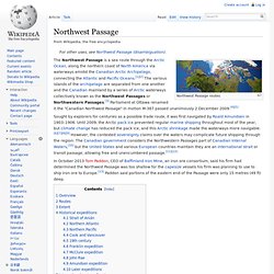
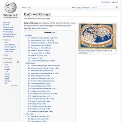
In October 2013 Tom Paddon, CEO of Baffinland Iron Mine, an iron ore consortium, said his firm had determined the Northwest Passage was too shallow for the capesize vessels his firm was planning to use to ship iron ore to Europe.[13] Paddon said portions of the eastern end of the Passage were only 15 metres (49 ft) deep. Early world maps. Early world maps cover depictions of the world from the Iron Age to the Age of Discovery and the emergence of modern geography during the early modern period.
Antiquity[edit] Babylonian Imago Mundi (c. 600 BCE)[edit] A Babylonian world map, known as the Imago Mundi, is commonly dated to the 6th century BCE.[1][2] The map as reconstructed by Eckhard Unger shows Babylon on the Euphrates, surrounded by a circular landmass showing Assyria, Urartu[3] and several cities, in turn surrounded by a "bitter river" (Oceanus), with seven islands arranged around it so as to form a seven-pointed star. The accompanying text mentions seven outer regions beyond the encircling ocean. The descriptions of five of them have survived:[4] Anaximander (c. 610 – 546 BCE)[edit] Reconstruction of Anaximander's map Hecataeus of Miletus (c. 550–476 BCE)[edit] Reconstruction of Hecataeus' map Eratosthenes (276–194 BCE)[edit] Posidonius (c. 150–130 BCE)[edit] Strabo (c. 64 BCE – 24 CE)[edit]
Tabula Rogeriana. The modern copy of the Tabula Rogeriana, upside-down with North oriented up.
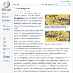
The Nuzhat al-mushtāq fi'khtirāq al-āfāq (Arabic: نزهة المشتاق في اختراق الآفاق, lit. "the book of pleasant journeys into faraway lands"), most often known as the Tabula Rogeriana (lit.