
Issues third new nautical chart for the Arctic. Chart aids safe shipping from Delong Mountain Terminal July 7, 2014 Vessels approaching Delong Terminal have been using this chart to supplement older NOAA chart 16005.
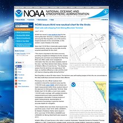
Note the lack of soundings outside the lane. (Click for a high resolution image. Credit: NOAA) NOAA has issued a new nautical chart for the Delong Mountain Terminal, a shallow draft port servicing the Red Dog Mine, one of the world’s largest producers of zinc concentrate, on the western coast of Alaska in the Arctic. New chart 16145 fills in historically sparse depth measurements, using new survey data recently acquired specifically for this chart. “This chart is important to the Arctic economy, providing navigational intelligence for the vessels shipping zinc and lead concentrate from Red Dog Mine and offers vastly more navigational information than the only other available chart of the area,” said Rear Admiral Gerd Glang, director of NOAA’s Office of Coast Survey.
Red Dog Mine is about 50 miles inland. Maritime-executive. October 11, 2014 By MarEx Op-Ed by Dermot Loughnane, CEO of Tactical Marine Solutions, Canada Just reading the headline of a recent article by Gary Strieker of Environment News Trust makes my teeth hurt: As Arctic Melts, Shipping Traffic Blasts Wildlife.
The use of the word “blasts” gives you a hint of what’s coming, though in 35 years I’ve never seen a commercial ship blast anything. The article says the rush is on for shipping and oil and gas development in the Arctic. Strieker is demonstrating how many people are confused and misinformed about the Arctic. Indigenous people have demonstrated their active involvement and their power to intervene (quite rightly) in development issues that could affect them. It can go the other way too, local communities on Baffin Island have objected to proposed seismic exploration off the east coast of their island. He also notes that “any industrialization there will be hazardous, raising extreme risks to life and the fragile environment”.
Melting Arctic opens new routes for energy shipping. Rising global temperatures are melting Arctic sea ice, so much so that some companies are now viewing the Arctic Ocean as a major shipping route for energy supplies.
The Wall Street Journal published an article on July 9 that detailed a joint venture between two major Asian companies seeking to ship liquefied natural gas (LNG) through the Arctic Ocean. Mitsui OSK of Japan and China Shipping Development Company announced a combined investment of $932 million on three LNG carriers that could handle the rough icy waters of the far north. China and Japan promise to be huge buyers of LNG in the coming years. China, with its cities suffocating from air pollution, is seeking to replace much of its coal fleet with cleaner burning natural gas. And Japan – which has long been the world’s largest importer of LNG – is still heavily dependent on LNG imports with its 48 nuclear reactors still offline. GNL : Total va inaugurer une nouvelle route par l’Arctique, Énergie - Environnement. Politique Primaire UMP : la cote de Nicolas Sarkozy pas affaiblie par les...

Nicolas Sarkozy conforte son avance sur Alain Juppé en dépit de sa mise en examen, selon un sondage diffusé vendredi. Transport de gaz naturel sibérien: Mitsui OSK commande 3 cargos brise-glace pour emprunter la route de l'Arctique. Transport de gaz naturel sibérien: Mitsui OSK commande 3 cargos brise-glace pour emprunter la route de l'Arctique Tokyo - La compagnie japonaise de fret maritime Mitsui OSK Lines a annoncé mercredi avoir commandé, avec son partenaire China Shipping, trois cargos brise-glace au constructeur sud-coréen Daewoo afin d'acheminer du gaz naturel sibérien en Asie et en Europe, en empruntant pour la première fois la route de l'Arctique.
Ce contrat, précise l'entreprise dans un communiqué, s'inscrit dans le cadre du gigantesque projet gazier de Yamal LNG, mené par une coentreprise du groupe local Novatek, le numéro deux russe du gaz après le géant public Gazprom, et du français Total. Ce projet gazier représente un investissement de 27 milliards d'euros. Longs de 299 mètres et larges de 50 m, les cargos, conçus par Daewoo Shipbuilding & Marine Engineering, pourront naviguer dans des mers glacées, par une épaisseur maximale de banquise de 2,1 m, indique Mitsui OK Lines. New Arctic port takes shape at Novoportovskoye. Novoportovskoye, the oil field located in the southeastern part of the Yamal Peninsula, is with its 250 million tons of resources one of Gazprom Neft’s biggest regional assets and a soon-to-be significant source for Arctic oil shipping.
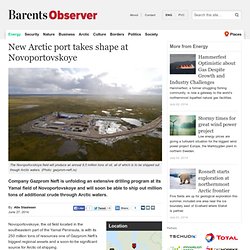
The company is now in full swing with the development the field, as well as a 100 km long pipeline and a 8,5 million ton/year capacity port and terminal at Cape Kamenny on the coast of the Ob Bay. From 2015, the port will enable Gazprom Neft to ship out the Novoportovskoye oil through the Ob Bay, most of it towards Murmansk, where it will be reloaded and forwarded to west European buyers. This year, the company will drill a total of nine wells at the field. Another 51 wells will be drilled before 2016, the company informs.
All operations are conducted by subsidiary company Gazprom Neft Novy Port.
Développement portuaire. Règles de navigation. Des limites persistantes. L'Arctique, un nouveau raccourci entre la Chine et l'Europe pour les cargos. Un cargo chinois navigue en Arctique pour la première fois.
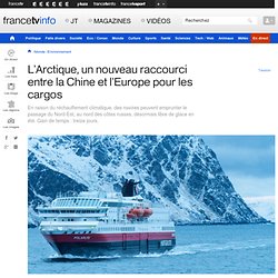
En à peine plus d'un mois, il va relier la Chine à l'Europe, en passant au nord des côtes russes. Il y a trois ans, il était encore hasardeux d'utiliser le passage du Nord-Est, même en été. Cette route maritime est aujourd'hui praticable à cause (ou grâce) au réchauffement climatique. Carte en temps réel des navires - AIS - trafic maritime et positions.