
Ledbury. Coordinates: Ledbury is a Herefordshire market town, lying east of Hereford, and south of the Malvern Hills.
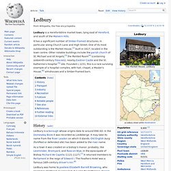
It has a significant number of timber-framed structures, in particular along Church Lane and High Street. One of its most outstanding is the Market House,[2] built in 1617, located in the town centre. Other notable buildings include the parish church of St. Michael and All Angels,[3] the Painted Room[4] (containing sixteenth-century frescoes), nearby Eastnor Castle and the St. History[edit] Ledbury is a borough whose origins date to around 690 AD.
As a town it was created on a bishop's manor, probably, like Leominster, Bromyard, and Ross-on-Wye, in the episcopate of Bishop Richard de Capella (1121-1127).[7] It returned members to Parliament in the reign of Edward I. Ledbury was home to poetess Elizabeth Barrett Browning, who spent her childhood at Hope End. Transport[edit] Industry[edit] Lymm. Coordinates: History[edit] The name, of Celtic origins, means a "place of running water" and is likely derived from an ancient stream that ran through the village centre.[2] Governance[edit] There is also a twelve-member Lymm Parish Council.
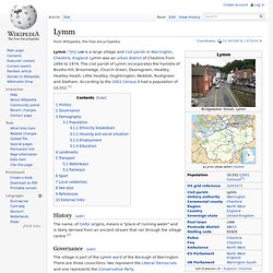
Following the 2012 elections, there are six Conservatives, three Liberal Democrats, two independents and one Labour councillor. Beswick, Manchester. Coordinates: Beswick is an area of the city of Manchester, in North West England.
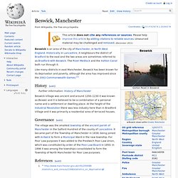
Historically in Lancashire, it neighbours the district of Bradford to the east and the two areas are sometimes referred to as Bradford-with-Beswick. The River Medlock and the Ashton Canal both run through it. Like many districts in east Manchester, Beswick has been known for its deprivation and poverty, although the area has improved since the 2002 Commonwealth Games.[1] History[edit] Beswick Village was ancient and around 1200–1230 it was known as Bexwic and it is believed to be a combination of a personal name and a settlement or dwelling place.
Governance[edit] References[edit] Leeds. Coordinates: 53°47′59″N 1°32′57″W / 53.79972°N 1.54917°W / 53.79972; -1.54917 Leeds.
Bristol. Bristol Montage of Bristol Motto: "Virtute et Industria" Coordinates: 51°27′N 2°35′W / 51.45°N 2.583°W / 51.45; -2.583 Sovereign state United Kingdom Constituent country England Region South West England Ceremonial county ( County corporate ) Admin HQ Royal Charter County status • Type. Chester. Coordinates: Chester (/ˈtʃɛstər/ CHESS-tər), is a city in Cheshire, England.
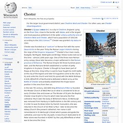
Lying on the River Dee, close to the border with Wales, and is the largest and most populous settlement of the wider unitary authority area of Cheshire West and Chester, which had a population of 328,100 according to the 2001 Census.[2] Chester was granted city status in 1541. Chester was founded as a "castrum" or Roman fort with the name Deva Victrix in the year 79 by the Roman Legio II Adiutrix during the reign of the Emperor Vespasian.[3] Chester's four main roads, Eastgate, Northgate, Watergate and Bridge, follow routes laid out at this time – almost 2,000 years ago.
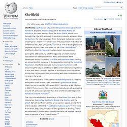
One of the three main Roman army camps, Deva later became a major settlement in the Roman province of Britannia. The Roman Empire fell three hundred years later, and the Romano-British established a number of petty kingdoms in its place. Sheffield. Sheffield i/ˈʃɛfiːld/ is a city and metropolitan borough in South Yorkshire, England.
Historically part of the West Riding of Yorkshire, its name derives from the River Sheaf, which runs through the city. With some of its southern suburbs annexed from Derbyshire, the city has grown from its largely industrial roots to encompass a wider economic base. Ellesmere Port. Coordinates: Ellesmere Port /ˈɛlzmɪərpɔrt/ is a large industrial town and port in Cheshire, England.
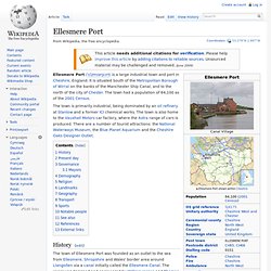
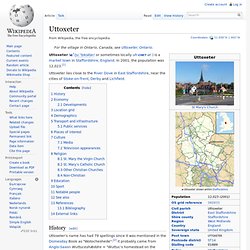
It is situated South of the Metropolitan Borough of Wirral on the banks of the Manchester Ship Canal, and to the north of the city of Chester. The town had a population of 64,100 as of the 2001 Census. The town is primarily industrial, being dominated by an oil refinery at Stanlow and a former ICI chemical works. Uttoxeter. Coordinates: Uttoxeter ( i/juːˈtɒksɨtər/ or sometimes locally uh-CHET-ər ) is a market town in Staffordshire, England.
Coleshill, Warwickshire. Coordinates: Coleshill (/ˈkoʊzəl/ KOH-zəl) is a market town in the North Warwickshire district of Warwickshire, England, taking its name from the River Cole.
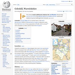
It has a population of 6,481 (2011 census)[1] and is situated 11 miles (18 km) east of Birmingham. Location[edit] Water Orton. Coordinates: Transport[edit] The village is close to the M6, M6 toll and M42 motorways.
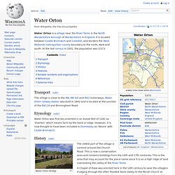
Water Orton railway station was built in 1842 and is located at the junction of the B4118 and Birmingham Road. Sunderland, Tyne and Wear. Coordinates: Sunderland ( i/ˈsʌndərlənd/, local /ˈsʊn(d)lən/) is a city which lies at the heart of the City of Sunderland metropolitan borough, a part of Tyne and Wear, in North East England. Bath (Bath, Somerset) - Bath - Places. Ashton upon Mersey. Coordinates: Ashton upon Mersey is an area of Sale in the Metropolitan Borough of Trafford, Greater Manchester, England. It lies on the south bank of the River Mersey, in the northwestern part of Sale, and is situated about 5 miles (8.0 km) south of Manchester city centre.
History[edit] A 4th-century hoard of 46 Roman coins was discovered and is one of four known hoards dating from that period discovered within the Mersey basin.[2][3] In the 18th century, it was thought that Ashton upon Mersey might have been the site of a Roman station, next to the River Mersey, called Fines Miaimae & Flaviae. However, this was based on the De Situ Britanniae, a manuscript forged by Charles Bertram, and there is no evidence to suggest any such station existed.[4] The name Ashton is Old English for "village or farm near the ash trees", suggesting that Ashton upon Mersey is of Anglo-Saxon origin.[5] The township is first mentioned in 1260.[6] The poet Lascelles Abercrombie was born in Ashton-upon-Mersey.
River Ouse, Yorkshire. The River Ouse (/ˈuːz/ OOZ) is a river in North Yorkshire, England. The river is formed from the River Ure at Cuddy Shaw Reach near Linton-on-Ouse, about six miles downstream of the confluence of the River Swale with the River Ure. It then flows through the city of York and the towns of Selby and Goole before joining with the River Trent at Trent Falls, near the village of Faxfleet, to form the Humber Estuary. Leicester. Coordinates: Leicester ( Timperley. Tintwistle Rural District. Tintwistle Rural District was a local government district in north east Cheshire, England from 1894 to 1974.[1] It was created a rural district by the Local Government Act 1894 from the part of the Ashton-under-Lyne rural sanitary district which was in Cheshire.
Hattersley. Kingston upon Hull. Hull, officially Kingston upon Hull ( Dukinfield. Audenshaw. Coordinates: Bath and North East Somerset - Bristol - Places. Hyde, Greater Manchester. Swindon. Coordinates: Swindon ( River Sheaf. Eccles, Greater Manchester. Barton-upon-Irwell. Bridlington. Berkshire.