
Working with feature classes. The feature class is one of the most commonly used data sources.
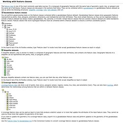
It is composed of geographic features with the same type of geometry (point, line, or polygon) and the same set of attributes. Feature classes are discussed in the sections that follow. They can be contained within a geodatabase or a geodatabase feature dataset as well as within the following structures: shapefile, coverage, CAD, SDC dataset, and VPF. Geodatabase feature classesYou can perform geoprocessing tasks on the feature classes contained within a geodatabase feature dataset.
Geodatabase feature classes store geographic features represented as points, lines, polygons, annotation, dimensions, and multipatches and their attributes. In the Search tab of the ArcToolbox window, type “feature class” to locate tools that accept geodatabase feature classes as input or output. CAD feature classesA CAD feature class is a read-only, in-memory member of a CAD feature dataset.
GIS Manual: Formats for Geographic Data. Geographic Data Resources Data are nothing but references to observations and measurements related to real-world or imaginary entities and phenomena.
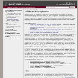
There are three fundamental means for organizing spatial data: Tables, Vector Feature Classes, and Raster Layers. These basic data provide a predictable means of organization, --schema--, that permit our tools to exchange information and to engage information with operations and to discover associations concerning information from different data sources. Related Documents ArcMap 101: Introduction to GIS Data and Portrayal provides a tour through an arcmap dataset with many different types of data and metadata. As we look more deeply into these structures, we will see that in each of the formal categories of data structure: Tabular, Vector & Raster, there are many choices in terms of the Technical Implementation for the way that they are encoded. Why are there so many choices?? Tables. CHARACTERIZING GEOGRAPHIC FEATURES.
All geographic features on the earth's surface can be characterized and defined as one of three basic feature types.
These are points, lines, and areas. Every geograpic phenomenon can in principle be represented by either a point, line, and/or an area. GIS Data Structures illustrating the difference between Vector and Raster formats (Adapted from Berry) Commonly, an identifier accompanies all types of geographic features. This description or identifier is referred to as a label. It is important to note that geographic features and the symbology used to represent them, e.g. point, line, or polygon, are dependant on the graphic scale (map scale) of the data. Data can always be generalized to a smaller scale, but detail CANNOT be created ! Remember, as the scale of a map increases, e.g. 1:15,000 to 1:100,000, the relative size of the features decrease and the following may occur: About shapefiles, dBASE tables, and file types. Free GIS Data - GIS Data Depot.
Digital Map Formats Vector File Formats Raster File Formats Information Types Software File Formats The term file format refers to the logical structure used to store information in a GIS file.
Almost every GIS has its own internal file format. If your data needs are simple, your main concern will be with the internal format your GIS software supports. Back to Top Many GIS applications are based on vector technology, so vector formats are the most common. Arc Export is a transfer format, either ASCII or compressed into binary used to transfer files between different versions of ARC/INFO. An ARC/INFO "coverage" is a set of internal binary files used by ARC/INFO, a GIS program. DWG is the internal, proprietary format used in AutoCAD® software, which is a computer-aided design/drafting (CAD) program. DXF is probably the most widely used vector data transfer format, and a file in DXF format offers some very strong advantages.
GIS Centre at Lund University. File Format (GIS) GIS data can be simply described as geographical data to which attributes have been linked.
Geographical data is all information that relates to space, for example, a road and a lake. Geographical features can be described with a matrix (raster data), or points, lines and polygons (vector data). The format of the file describes in which way the geographical features have been saved. It is very important to consider the file format of GIS data because software programs rarely support all file types. Nearly all GIS programs have their own file format.