
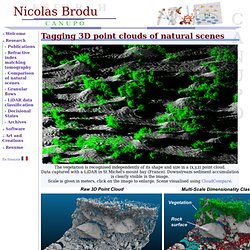
Digital photogrammetry. CAractérisation de NUages de POints (CANUPO) The vegetation is recognised independently of its shape and size in a (x,y,z) point cloud.Data captured with a LiDAR in St Michel's mount bay (France).
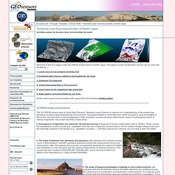
Downstream sediment accumulation is clearly visible in the image.Scale is given in meters, click on the image to enlarge. Scene visualised using CloudCompare. Recognising automatically the elements of mountain river stream scene. Data captured with a LiDAR at the Otira river, New-Zealand, by Dimitri Lague. Consider a scene comprising rocks, sand, and vegetation patches.
The article is available here and on the ArXiv. Download the program for Linux 64 bits and/or Windows 64 bits (or for 32bits older computers or antiquities). A tutorial is included within the above packages. The source code is maintained in my source repository, check it for updates. Canupo is Free/Libre software released under the LGPL v2.1 or more recent. Géosciences Rennes - UMR6118 - Terrestrial Laser Scanning activities of Dimitri Lague. Welcome to the TLS pages of the 3D-VEROS project lead by Dimitri Lague.
This page is under construction, but you can (or soon will be able to...) : 1. 2. 3. 4. 5. 6. All this work would only be possible with support from the following funding bodies. Mobile Laser Scanning in Venice - April 2011, Volume 25, Number 4 - Archive. The IUAV CIRCE Photogrammetry Lab presented its project idea to RIEGL following contacts with the company’s Italian distributor, Microgeo srl.
After considerable R&D efforts, a new, modular camera system was integrated into the RIEGL VMX-250 in September 2010.
Terrestrial Laser Scanning (TLS) Since its inauguration, the LVML acquires 3D Landscape data with the technique of 'terrestrial laser scanning' (TLS).
The measurement of the landscape with such systems allows the generation of highly detailed digital height models (DHM) which can be used as a basis for realistic 3D visualisations, accurate topography modellings and CNC based processing for the generation of physical models, among other functions. IRL member Thomas Klein at work at Ritigraben, Wallis The use of a terrestrial laser scanner relies on a moderate user expertise and the use of specialized hard- and software. Besides the necessary expert knowledge - for example about reflection properties of the laser on the object - main focuses of interest are the distance, resolution and scan position.
The speed of the technique can vary based on individual characteristics of the site, each individual site requires a strategy to minimize the scanning time and maximize the accuracy and even density of the scanned result. Terrestrial Laser Scanning « McMullen Nolan GroupMcMullen Nolan Group. Providing a safer, more precise alternative to traditional survey and dimensional control methods, McMullen Nolan Group's Terrestrial Laser Scanning services are able to capture, visualise and model complex structures, sites and features.
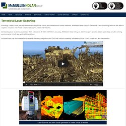
Conducting laser scanning operations from a distance of 100m with 6mm accuracy, McMullen Nolan Group is able to acquire precise data in potentially unsafe working environments in both day and night conditions. Acquired data can be modelled and rendered for easy integration into CAD and various modelling software such as PDMS, AutoPlant and Navisworks.
Application of ground based LiDAR for monitoring & stability analysis of dump slope in open pit mine: A Case Study - Directions Magazine India. In surface mining, slope stability and slope monitoring of bench’s high wall, spoil dumps/heaps are not yet included as integral part of total pit design in India.
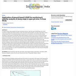
This subject gets importance only when slope failure occurs, raising danger alarm of encompassing present conditions to be considered in view with the entire mining operations or when failure is impending. Slope failure problems continue to be a source of human & financial losses. Recent failures at a few open cast mines serve to emphasize that additional study is needed in slope design and monitoring. This study exhibits the geodetic technique of predicting slope displacements in overburden dumps and bench high-wall at mechanised open pit (coal).
Chartered Land Surveyors & Geomatics, Shropshire, UK & Worldwide » Monitoring & Deformation Surveys. Atlantic Productions. 6 x 1 hours Time Scanners, presented by Dallas Campbell, unlocks the secrets of the world’s most iconic engineering feats using cutting-edge, 3D laser scanning technology.

A team of scientists and historians led by Steve Burrows (engineer for the Beijing Bird’s Nest Olympic Stadium), uses the extraordinary scans to create 3D digital models of the Roman Coliseum, the Egyptian Pyramids, the Incas’ Machu Picchu, St Paul’s in London, Petra and Jerusalem with pin-point accuracy. With this unique tool and insider access, the team can analyse how good the ancient engineers were, make brand new discoveries, and come up with ground breaking new theories about these awe-inspiring places and the people who built them.
As-Built Reality Capture for BIM: AECbytes Viewpoint. AECbytes Viewpoint #66 (November 29, 2012) 3D Laser Scanning: As-Built Reality Capture for BIM Scott Page, MArch, U.C.
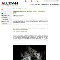
Berkeley Founder, Scott Page Design If you are unfamiliar with the terms; LiDAR, 3D laser scanning, point clouds, meshes, and NURBS, this article might scare you off, but I would hang on and hopefully learn something about reality capture from 3D laser scanners and the “point clouds” they generate. 3D LiDAR Client - DielmoOpenLiDAR - DIELMO 3D. LIDAR-Lite by PulsedLight. The founders of PulsedLight, Bob Lewis and Dennis Corey, recognized that there was an unmet need for an optical distance measurement sensor technology that addressed applications where a very small, low-power, high performance, reduced cost optical ranging sensor was required, such as robotics and UAVs.
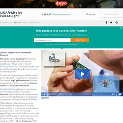
So in 2011 they co-founded PulsedLight, LLC in Bend, Oregon to bring their vision for a new optical ranging sensor technology to market. After more than two years of work, we are ready to introduce our technology in the form of the LIDAR-Lite, a very small form factor, optical distance measurement sensor capable of measuring out to 40 meters using inexpensive, off-the-shelf, electro-optical components. First, a Little Science All optical ranging sensors use the principle of “Time-of-Flight” (ToF) to calculate distance to a target. Simply put, ToF calculates the time it takes for a signal, light in this case, to travel from the sensor to a target and back to determine distance. Applied Imagery » Features. Visualize Visualize massive DEMs and Point Clouds and navigate in real time.
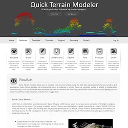
Build QT Modeler builds enormous DEMs and point clouds from various data formats. Edit Allows quick cutting, cropping, and area smoothing by selection areas. Understand Easily understand your data through interactive visualization and analysis tools. 3D Laser Scanning - Customer Stories. Portable, Powerful, Accessible. Maverick is a portable, powerful, and accessible spatial data collection system.
Combining high-resolution 360º imaging, high-definition LiDAR, and an integrated position and orientation system, Maverick is capable of efficient and accurate mobile data collection. The vehicle-mounted system is able to operate in a wide range of conditions and can be utilized for projects of any size and scope. Certainty 3D - Products. LiDAR USA. LiDAR USA.