
How Australia's massive bushfires are generating thunderstorms. Every decision counts.
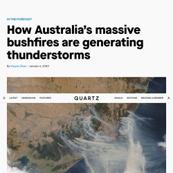
Big natural disasters can create their own weather systems. The Australian bushfires are now so intense that they’re starting to make thunderstorms. On Jan. 3, Australia’s meteorology bureau issued a severe thunderstorm warning for East Gippsland in Victoria. The thunderstorm condition is also happening in New South Wales, another state with intense fires and smoke. The bureau explained the formation of fire-generated thunderstorms on social media: Essentially, when hot air and smoke from bushfires rises and meets cool air from the atmosphere, it turns into pyrocumulus clouds, also known as “fire clouds.”
The thunderstorms can lead to two atmospheric events that could quickly damage a large area: downbursts and lightning. In the event of a downburst, the cooling wind can travel as fast as 170 miles per hour (270 km/h), knocking over fully grown trees. As global temperatures rise, pyrocumulus clouds may become more common. This is how most bushfires in Australia start, and how we know - Science News - ABC News. As fires continue to burn in different parts of Australia, investigators work to provide answers on the exact causes of devastating blazes.
Last week we learnt that the Binna Burra fire, which destroyed the historic Binna Burra Lodge in South East Queensland, was started by a carelessly discarded cigarette. And the Gold Coast hinterland bushfires the week before may have been started by army live-firing exercises at the Kokoda Barracks, a spokesperson for the Australian Defence Force has conceded.
We know that hot, dry and windy weather increases the risk of fires starting, but here's what we know about what actually provides the spark. The nine categories of bushfire ignition Fire investigators have nine categories for the ignition sources of fires: Smoking: Smoking isn't as common a source of bushfire ignition as we might think. Australia bush fires create their own weather, including thunderstorms. Bushfire weather. Australia's fire weather seasons While bush fires can happen at any time of the year in Australia, the time of peak bushfire activity varies across the country with the changes in the seasonal weather patterns.
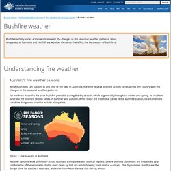
For northern Australia the peak bushfire period is during the dry season, which is generally throughout winter and spring. In southern Australia the bushfire season peaks in summer and autumn. While these are traditional peaks of the bushfire season, local conditions can drive dangerous bushfire activity at any time. Figure 1: Fire seasons in Australia Weather systems work differently across Australia's temperate and tropical regions. Southeast Australia—summer and autumn As grass and forests dry during summer and autumn, southeast Australia becomes vulnerable to the threat of bushfire. New South Wales and southern Queensland—spring to mid-summer The greatest danger occurs after the dry winter and spring. Northwest Western Australia and the Northern Territory—winter and spring Humidity. Australia bushfires create their own dangerous weather systems, experts say.
Thick plumes of smoke rise from bushfires at the coast of East Gippsland, Victoria, Australia January 4, 2020 in this aerial picture taken from AMSA Challenger jet.
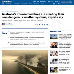
Australian Maritime Safety Authority | Reuters The bushfires in Australia are creating violent weather systems that can spark new fires, conjure fire tornadoes and make fighting existing fires much more challenging, experts say. The rising heat from the intense bushfires creates massive, powerful clouds called pyrocumulonimbus, or pyroCb. These “fire clouds” are created “when fires loft enough heat and moisture into the atmosphere” to produce smoke-infused thunderstorms, according to the NASA Earth Observatory.
Mike Fromm, a meteorologist at the U.S. “They are a combination of a regular thunderstorm that everybody is very, very familiar with, but with the explosive heat source from the fire which actually makes them very peculiar,” Fromm said. Australia's Deadly Bushfires Are So Big They've Started Generating Their Own Weather. The Australia bushfires are generating "pyrocumulonimbus" clouds, which create their own thunderstorms that can start more fires.Here's how the process works, and why it's so dangerous.Visit Insider.com for more stories.
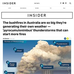
The bushfires in Australia are now so big that they are generating their own weather, in the form of giant thunderstorms that start more fires, according to the Bureau of Meteorology in Victoria. "Pyro-cumulonimbus clouds have developed to altitudes over 16km in East #Gippsland this afternoon. These fire-induced storms can spread fires through lightning, lofting of embers and generation of severe wind outflows," the bureau tweeted on Monday.
Satellite photography shows the intense smoke generating atmospheric clouds: Intense fires generate smoke, obviously. Eventually, water droplets in the cloud condense, generating a downburst of rain — maybe. If powerful enough, a pyrocumulonimbus storm can generate a fire tornado, which happened during the Canberra bushfires in 2003.