
Untitled. Al Jazeera Correspondent - Haiti: After the Quake. How to Make a Tornado in a Bottle: 12 Steps. WikiHow is a “wiki,” similar to Wikipedia, which means that many of our articles are co-written by multiple authors.
To create this article, 97 people, some anonymous, worked to edit and improve it over time. Together, they cited 10 references. Categories: Air Experiments. Scottish wildfires mapped using satellite data. Fissura 8 no vulcão Kilauea, nunca vi lava se mover tão rápido. Stop Disasters. Two years after the earthquake, why has Nepal failed to recover? Two years after the devastating earthquakes that struck Nepal, the country is struggling to bounce back.
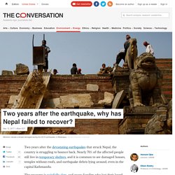
Nearly 70% of the affected people still live in temporary shelters, and it is common to see damaged houses, temples without roofs, and earthquake debris lying around, even in the capital Kathmandu. The recovery is painfully slow, and many families who lost their loved ones continue to live in traumatic conditions. Over the past two years, working with CARE Nepal and the Southasia Institute of Advanced Studies, we have talked to local communities in the Gorkha, Kathmandu and Kavre districts, and helped to organise a national workshop involving senior government officials, researchers and civil society actors. Devastation. Course: Before the Flood.
Tectonic activity and hazards: earthquakes. Facebook. Economist. Earthquakes in the Himalaya are bigger than in the Alps because tectonic plates collide faster. Earthquakes that happen in densely populated mountainous regions, such as the Himalaya, spell bigger earthquakes because of a fast tectonic-plate collision, according to a new study in Earth and Planetary Science Letters.
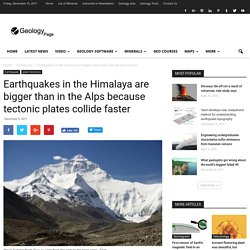
Researchers from Geophysical Fluid Dynamics — ETH Zürich in Switzerland, say their findings give people a more complete view of the risk of earthquakes in mountainous regions. The new study shows that the frequency and magnitude of large earthquakes in the densely populated regions close to mountain chains — such as the Alps, Apennines, Himalaya and Zagros — depend on the collision rate of the smaller tectonic plates. In 2015, a magnitude 7.8 earthquake struck Gorkha-Nepal, and a year later, Norcia, Italy suffered a magnitude 6.2 earthquake. Previous research has attempted to explain the physical causes of earthquakes like these, but with ambiguous results. Lava (From "Lava" (Official Lyric Video)) Great little video from California... - Geographical Association. Earthquake early warning in Mexico reminds California what it still lacks. The massive earthquake that ripped through Mexico is offering stark testimony on the power of modern early warning systems that, to the dismay of seismologists who have spent years pushing the technology, do not exist in California or anyplace in the United States.
Experts believe the growing death toll from Thursday’s 8.1-magnitude quake off Mexico’s southern coast could have been worse if alarms had not gone off throughout faraway population centers well before the shaking started. The temblor, which struck just before midnight, knocked down buildings and caused skyscrapers to sway hundreds of miles away in Mexico City, but television newscasters, businesses and utility companies there got as much as 92 seconds to warn people and take other steps to protect them. Dope Traveling - □ Bungee Jumping into a Volcano! □ Chile □□ The UN Has Called This The Second Biggest Environmental Problem Facing Our World.
Is it worth poisoning people to collect some gold?
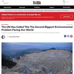
That’s the question now facing Romania’s Prime Minister Mihai Tudose as he contemplates reopening the Rosia Montana goldfield. Rosia Montana holds 314 tons of gold and so offers the prospect of making millions and creating short-term employment opportunities for thousands of workers. This New Map Shows You How Many Years of Life Pollution Has Taken Away From You Based Off Where You Live. 4.5 billion — that’s how many people around the world today are exposed to levels of air pollution that are at least twice what the World Health Organization (WHO) considers safe.
And until now, the impact of prolonged exposure to pollution on a single person’s life expectancy has remained largely unanswered. Now, this information has become publicly available. And it might shock you. Dear Global Leaders, Disease neither recognizes nor respects borders or walls. In our increasingly interconnected world, we must band together to ensure that we have the necessary infrastructure and systems in place to prevent the next disease outbreak from devastating our world.
Bizarre ‘Lava-Like’ Landslide Tears Through Hillside. Latest Earthquakes. LiveScience - Here's what you need to do if you find... Science Insider - Most hurricanes that hit the US come... Why So Many People Don't 'Just Leave' When A Major Hurricane Hits. Weather Infographics. Simon King explains what hurricanes, cyclones and typhoons are - CBBC Newsround. Huge landslide triggered rare Greenland mega-tsunami : Nature News & Comment.
Channel 4 - This will rock your world. Interactive Map Shows Where You'd Pop Up If You Dug Straight Through The Earth. Earth. Steve backshall exteme. Comments. Extra layer of tectonic plates discovered within Earth's mantle, scientists say. Scientists say they have found a possible layer of tectonic plates within the Earth’s mantle which could explain a mysterious series of earthquakes in the Pacific.
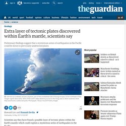
For more than half a century scientists have known that continents drift over the surface of our planet, and that the ocean floor tears apart in their wake, with magma from the mantle filling the gap. At the other end of the process, where tectonic plates converge, oceanic plates plunge into the deeper mantle in a process called subduction. On Tuesday, Jonny Wu of the University of Houston presented preliminary evidence of possible plate tectonics within the mantle to a joint conference of the Japan Geoscience Union and the American Geophysical Union in Tokyo. Twitter Card. Sentinel satellites to monitor every volcano. Image copyright Getty Images A UK-led team of scientists is rolling out a project to monitor every land volcano on Earth from space.
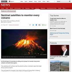
Two satellites will routinely map the planet's surface, looking for signs that might hint at a future eruption. They will watch for changes in the shape of the ground below them, enabling scientists to issue an early alert if a volcano appears restless. Some 1,500 volcanoes worldwide are thought to be potentially active, but only a few dozen are heavily monitored. One of these is Mount Etna where, last month, a BBC crew was caught up in a volcanic blast while filming a report on the new satellite project. The world's five deadliest volcanoes ... and why they're so dangerous. An eruption of Mount Etna recently caught out some BBC journalists who were filming there.
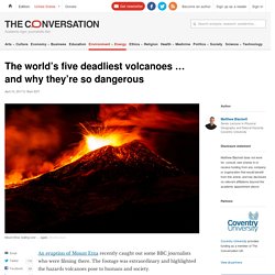
The footage was extraordinary and highlighted the hazards volcanoes pose to humans and society. Since 1600, 278,880 people have been killed by volcanic activity, with many of these deaths attributed to secondary hazards associated with the main eruption. Starvation killed 92,000 following the 1815 Tambora eruption in Indonesia, for example, and a volcanic tsunami killed 36,000 following the 1883 Krakatoa eruption. Bang Goes the Theory s04ep01 Japanese earthquake special WnA. Dataset. Description This animation shows every recorded earthquake in sequence as they occurred from January 1, 2001, through December 31, 2015, at a rate of 30 days per second.
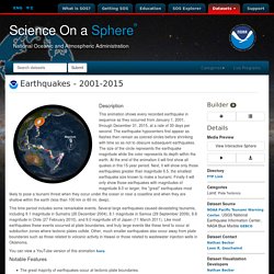
The earthquake hypocenters first appear as flashes then remain as colored circles before shrinking with time so as not to obscure subsequent earthquakes. The size of the circle represents the earthquake magnitude while the color represents its depth within the earth. At the end of the animation it will first show all quakes in this 15-year period. Next, it will show only those earthquakes greater than magnitude 6.5, the smallest earthquake size known to make a tsunami. This time period includes some remarkable events. Earth's Volcanoes - Documentary. The Really Big One. When the 2011 earthquake and tsunami struck Tohoku, Japan, Chris Goldfinger was two hundred miles away, in the city of Kashiwa, at an international meeting on seismology. As the shaking started, everyone in the room began to laugh. Earthquakes are common in Japan—that one was the third of the week—and the participants were, after all, at a seismology conference.
San Andreas fault ‘ready to go,’ expert warns of major earthquake. A massive earthquake looms for Southern California, according to one expert. Thomas Jordan, director of the Southern California Earthquake Center, shared his ominous warning during this week's National Earthquake Conference in Long Beach.
Kevin Schafer/Getty Images/Minden Pictures RM The San Andreas fault is due for a massive earthquake, one expert said. Harry and Friends explain fumaroles. Earth - The Cracks Ripping Earth Apart. Standing here at Thingvellir, I may be looking at something quite new: the achingly slow birth of a new continent. Sigmundsson tells me that a new "micro plate" is forming beneath our feet. This "special Icelandic plate" is continually expanding as new crust forms on either side of it.
The consensus is that this marks a passing separation from the rest of the rift zone. ShelterBox Provides Shelter, Warmth And... - The Huffington Post. Cyclone Winston: Village built by Australian man for Fiji's poor survives unscathed. Updated. Lesson Ideas for Teachers. Pre & Post Visit Material... We have worked very closely with practicing teachers to develop a range of activities suitable for you to use in the classroom, the school hall or even the playground. Landward 05/02/2016 BBC Documentary 2016.
Earthquakes & Volcanoes - Geography for 2014. TDAT. 10 Surprising Facts About Yellowstone. Supervolcano (full movie) Yellowstone Caldera : The Biggest Volcanic Eruption Ever Awaits Mankind. Lost Lake in Oregon Mysteriously Disappearing Down a Hole. Movie - RDlessons.com. CGF3M-Physical Geography. The Family who Inspired “The Impossible” Click on the link to read the news story about the family who inspired the movie you will finish today, “The Impossible”. The Impossible (Movie) worksheet. Beijing Issues First-Ever 'Red Alert' Over Air Pollution. Sinkholes - Geography for 2015. Indonesia is burning. So why is the world looking away? Why the Philippines is Being Battered By Yet Another Fearsome Typhoon.
Updated Monday at 11 a.m. Shutting the flood gates. Untitled. India: 200,000 refugees in Assam's devastating floods. Nepal earthquake: Before and after - BBC News. Nepal was made vulnerable by more than its violent geology. Nepal earthquake. Teachit Geography sur Twitter : "Useful KS3 #map for aid for #NepalEarthquake #geographyteacher #place #development @AFP. Are Earthquakes and Volcano Activity on the Rise? Here's How Long It Would Take To Fall Through The Center Of Earth. If the Yellowstone Supervolcano ever blew its top, this new study shows us what to expect. Are we ready for the next volcanic catastrophe? Geologists May Have Just Discovered A New Layer Of Earth's Mantle. Convection in Earth’s Mantle. How to teach … volcanoes. Where did the Indian Ocean tsunami aid money go? BBC Science - Four ways to be killed by a volcano. Huffingtonpost. Tropical Storm Erika kills at least 20 in Dominica - BBC News.
The economic aftershocks of Nepal’s earthquake. Rebuilding a Post-Katrina Food System.