
iSTAR systems - NCTech panoramic cameras. FARO Scan Localizer - Overview. The FARO Scan Localizer is a state-of-the-art scanning accessory that streamlines the registration process on-site substantially increasing productivity in complex planning projects.
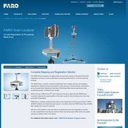
The FARO Scan Localizer combines information from multiple sensors and software algorithms to determine the exact position of the scanner inside buildings. It allows the as-built capturing for (Building Information Modelling) BIM related applications with unmatched speed, confidence and quality. While moving a FARO Focus3D Laser Scanner through a large site, the FARO Scan Localizer captures the exact position of the laser scanner, thus enabling error free, fully automated registration. FARO Scan Localizer performs automatic on-site registration of 3D scans directly in FARO SCENE Software and maps the scan space in real-time while the FARO Easy Flow SCENE App registers the scans in real time.
For additonal information please visit FARO Early Adopter Program website. Mantis Vision. ATS Products - Scan reference system for 3D laser scanning. Kreon Technologies - Measuring arms and 3D laser scanners. Registration Spheres On Precision Plastic Ball Co. 3D Scanning & Metrology Rentals. 3D SCAN IT - Providers of premier optical measurement technology. DPI-8 Handheld Scanner. Drone (UAV) Aerial LiDAR & Surveying. VulcanUAV. UAV Vermessung & Kartografie /// Vermessungsdrohne : Ascending Technologies GmbH. Bridge inspection & survey. /// Generate georeferenced 2D & 3D information to assess & decide.
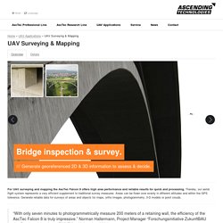
For UAV surveying and mapping the AscTec Falcon 8 offers high area performance and reliable results for quick and processing. Thereby, our aerial flight system represents a very efficient supplement to traditional survey measures. Areas can be flown over evenly in different altitudes and within the GPS tolerance. Generate reliable data for surveys of areas and objects for maps, ortho images, photogrammetry, 3-D models or point clouds. “With only seven minutes to photogrammetrically measure 200 meters of a retaining wall, the efficiency of the AscTec Falcon 8 is truly impressive.” /// Benefit from the technical details. /// The AscTec Falcon 8: A valuable supplement to your existing instruments and devices. The AscTec Falcon 8 will not replace conventional methods; it will rather perfectly complement classic methods. /// Operating everywhere.
Proven in daily routines. Velodyne Lidar. NEW RIEGL RiCOPTER VUX-SYS. To use the RiCOPTER for acquisition of high-accuracy, high-resolution laser scan and image data, the UAS is equipped with the RIEGL VUX-SYS, comprising the VUX-1 LiDAR sensor, a IMU/GNSS unit, a control unit, and up to four high-resolution cameras.
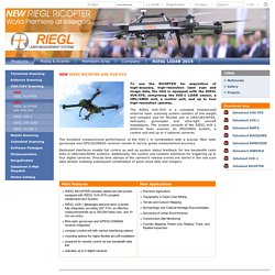
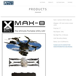
The RIEGL VUX-SYS is a complete miniaturized airborne laser scanning system solution of low weight and compact size for flexible use in UAS/UAV/RPAS, helicopter, gyrocopter and ultra-light aircraft installations. The system consists of the RIEGL VUX-1 airborne laser scanner, an IMU/GNSS system, a control unit and up to 4 optional cameras. The excellent measurement performance of the VUX-1 in combination with a precise fiber optic gyroscope and GPS/GLONASS receiver results in survey grade measurement accuracy. Dedicated interfaces enable full control as well as system status feedback for low bandwidth radio links in UAS/UAV/RPAS systems. Additionally, the control unit contains interfaces for triggering up to four digital cameras. XactSense. Name : XactSense SSP-360 Stable Sensor Platform Version: Currently on V2 Gimbal Drive : High Quality Brushless Gimbal Motors Onboard CPU: 2.0Ghz quad core and Cortex™-A7 quad core CPUs Connectivity: 5.8ghz wifi TCP Sensor options:
Phoenix Aerial Systems. Intelligent, scalable, and fully autonomous data capture solution. Koppa Target Spheres - Welcome.