
The southern plane of the Milky Way from the ATLASGAL survey (annotated) A spectacular new image of the Milky Way has been released to mark the completion of the APEX Telescope Large Area Survey of the Galaxy (ATLASGAL).
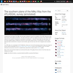
The APEX telescope in Chile has mapped the full area of the Galactic Plane visible from the southern hemisphere at submillimetre wavelengths — between infrared light and radio waves. The new finely detailed images complement those from recent space-based surveys. The pioneering 12-metre APEX telescope allows astronomers to study the cold Universe: gas and dust only a few tens of degrees above absolute zero. The APEX data, at a wavelength of 0.87 millimetres, shows up in red and the background blue image was imaged at shorter infrared wavelengths by the NASA Spitzer Space Telescope as part of the GLIMPSE survey. The fainter extended red structures come from complementary observations made by ESA's Planck satellite. Credit: ESO/APEX/ATLASGAL consortium/NASA/GLIMPSE consortium/ESA/Planck.
ATLASGAL Survey of Milky Way Completed. Eso1606 — Photo Release 24 February 2016 A spectacular new image of the Milky Way has been released to mark the completion of the APEX Telescope Large Area Survey of the Galaxy (ATLASGAL).
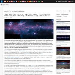
The APEX telescope in Chile has mapped the full area of the Galactic Plane visible from the southern hemisphere at submillimetre wavelengths — between infrared light and radio waves. This is the sharpest such map yet made, and complements those from recent space-based surveys. The pioneering 12-metre APEX telescope allows astronomers to study the cold Universe: gas and dust only a few tens of degrees above absolute zero. APEX, the Atacama Pathfinder EXperiment telescope, is located at 5100 metres above sea level on the Chajnantor Plateau in Chile’s Atacama region. The new ATLASGAL maps cover an area of sky 140 degrees long and 3 degrees wide, more than four times larger than the first ATLASGAL release [3].
The southern plane of the Milky Way from the ATLASGAL survey. This image of the Milky Way has been released to mark the completion of the APEX Telescope Large Area Survey of the Galaxy (ATLASGAL).
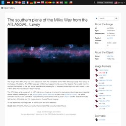
The APEX telescope in Chile has mapped the full area of the Galactic Plane visible from the southern hemisphere for the first time at submillimetre wavelengths — between infrared light and radio waves — and in finer detail than recent space-based surveys. The APEX data, at a wavelength of 0.87 millimetres, shows up in red and the background blue image was imaged at shorter infrared wavelengths by the NASA Spitzer Space Telescope as part of the GLIMPSE survey.
The fainter extended red structures come from complementary observations made by ESA's Planck satellite. Note that the far right section of this long and thin image does not include Planck imaging. To fully appreciate this image click on it and zoom and scroll sideways. Credit: Visions of the Future. Imagination is our window into the future.

At NASA/JPL we strive to be bold in advancing the edge of possibility so that someday, with the help of new generations of innovators and explorers, these visions of the future can become a reality. As you look through these images of imaginative travel destinations, remember that you can be an architect of the future. Click on any of the thumbnails below to learn more and download a free poster sized image.
Untitled. Hs-2003-28-a-full_jpg. The Histomap. 1810001. BibliOdyssey: Victorian Infographics. A time table indicating the difference in time between the principal cities of the World and also showing their air-line distance from Washington.

IN: 'Mitchell's New General Atlas, Containing Maps Of The Various Countries Of The World, Plans Of Cities, Etc., Embraced In Ninety-Three Quarto Maps, Forming A Series Of One Hundred and Forty-seven Maps and Plans, Together With Valuable Statistical Tables..' by Samuel Augustus Mitchell Jr, 1883; published in Philadelphia by WM Bradley. Tableau d'Astronomie et de Sphère IN: 'Atlas Universel d'Histoire et de Geographie Anciennes et Modernes, de Mythologie, des Religions, d'Astronomie, de Physique, de Geologie, de Histoire Naturelle, de Grammaire, de Rhetorique..' by Henri Duval, 1834; published in Paris by L Houbloup. Tableau d'Astronomie et de Sphère [detail] GeoRisk * Földrengés Mérnöki Iroda * Earthquake Engineering. GLIMPSE360: Spitzer's Infrared Milky Way. Poster Download the full resolution poster file for printing.
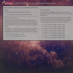
GLIMPSE360 Poster • tif • 306mb • 24,000 x 14,500 Planetarium Systems These files assemble the GLIMPSE360 image in a single all-sky equirectangular projection. The resolution is vastly reduced from the native image scale, but the files should be easily incorporated into any software that renders a spherical sky dome from a single image. The images are in galactic equirectangular coordinates centered at l, b = 0, 0.
All Sky 8k • tif • 2mb • 8,192 x 4,096 All Sky 24k • tif • 18mb • 24,575 x 12,288 Raw Data Files The raw data files are very big. These source files each span 45 x 10 degrees and are in galactic coordinates using an equirectangular projection. DeviantArt - The largest online art gallery and community. Map_of_the_internet_2_0__by_jaysimons-d781bst.jpg (JPEG Image, 4827 × 3206 pixels) - Scaled (21%) Felfedezések.png (PNG Image, 2400 × 2400 pixels) - Scaled (41%) Page.