
Wandermap. Google Earth Map Overlays. Europas größte Outdoor-Plattform. Radroutenplaner BW. Outdooractive.com. KOWOMA.de. GPX Resources. GPX, the GPS Exchange Format, is supported by hundreds of software applications and Web sites, making it the standard format for interchanging GPS data between GPS receivers, desktop and mobile software, and Web-based services.
Windows GPX Software Mobile GPX Software GPX-enabled software for Mobile Phones and PocketPC and Palm PDAs: Macintosh GPX Software Multiple Platform Support The following GPX software programs run on multiple platforms: Online GPX Applications Online applications that support GPX: Web sites with GPX data Data in GPX form is available at the following Web sites: GPX / Google Maps Mashups. EasyGPS. GPS converter. Convert CSV, GPX, OV2, KML, LMX, etc. GPSBabel: convert, upload, download data from GPS and Map programs.
Gmaps GPS Route Planner. Route Name: Search: Tools and Options To import a GPX file, paste its contents here and click OK.
To save, copy the text below, paste it into a text editor, and save from there. Marengo GPS Route Planner $Revision: 1.2 $ Copyright © 2007 Marengo Ltd (by Martyn Davis) This program (not Google Maps) is released under the GPL. GPSplanner.Net. Gmaps Pedometer. Distance Between Cities Places On Map Distance Calculator. GPS Geoplaner.
Gmapcatcher. Overview GMapCatcher is an offline maps viewer.
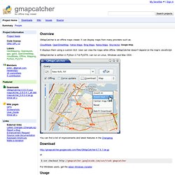
It can display maps from many providers such as: CloudMade, OpenStreetMap, Yahoo Maps, Bing Maps, Nokia Maps, SkyVector, Google Map. It displays them using a custom GUI. User can view the maps while offline. GMapCatcher is written in Python 2.7 & PyGTK, can run on Linux, Windows and Mac OSX. You can find a list of improvements and latest features in the Changelog Download or $ svn checkout gmapcatcher For Windows users, get the latest Windows installer Usage maps.py is a gui program used to browse google map. After version 0.04, user can force GMapCatcher to re-download old map tiles by checking "Force update".
Download.py is a downloader tools that can be used to download map tiles without gui. maps can use files it downloaded without configuration. Below is an example using download.py: $ download.py --location="Paris, France" --max-zoom=16 --min-zoom=0 --latrange=2.0 --lngrange=2.0 Files Linux: $HOME/.GMapCatcher/* Windows: GPS Visualizer. uTrack - online GPX track report generator. GPS-Track-Analyse.NET. GPXViewer. RouteConverter. GpsPrune. GpsPrune is an application for viewing, editing and converting coordinate data from GPS systems.
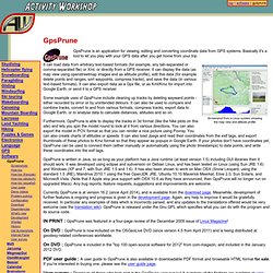
Basically it's a tool to let you play with your GPS data after you get home from your trip. Screenshot from a Linux system showingthe map view and altitude profile It can load data from arbitrary text-based formats (for example, any tab-separated or comma-separated file) or Xml, or directly from a GPS receiver. It can display the data (as map view using openstreetmap images and as altitude profile), edit this data (for example delete points and ranges, sort waypoints, compress tracks), and save the data (in various text-based formats). It can also export data as a Gpx file, or as Kml/Kmz for import into Google Earth, or send it to a GPS receiver. Some example uses of GpsPrune include cleaning up tracks by deleting wayward points - either recorded by error or by unintended detours. Currently GpsPrune is at version 16.2 (since April 2014), and is available from the download page.
Version 16.2!