
SEQ RealTime Baselines. The Kilauea GPS network is run and maintained by the USGS Hawaiian Volcano Observatory (HVO) in collaboration with the Pacific GPS Facility (PGF) of SOEST, University of Hawaii, and Stanford University.
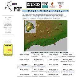
Trimble NetRS and Ashtech Z-X11 GPS receivers are in operation, and data files are telemetered hourly to HVO. Crustal Deformation and Fault Mechanics - Kilauea volcano. We have developed a continuous Global Positioning System (GPS) network on Kilauea volcano, in collaboration with the U.S.G.S.
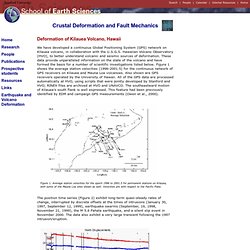
Hawaiian Volcano Observatory (HVO), to better understand volcanic and seismic sources of deformation. These data provide unparalleled information on the state of the volcano and have formed the basis for a number of scientific investigations listed below. Figure 1 shows the average station velocities (1996-2001.5) for the continuous network of GPS receivers on Kilauea and Mauna Loa volcanoes. Also shown are GPS receivers operated by the University of Hawaii. All of the GPS data are processed automatically at HVO, using scripts that were jointly developed by Stanford and HVO; RINEX files are archived at HVO and UNAVCO. Figure 1. Figure 2. Capteurs de déformation. Les capteurs de déformation Un volcan est loin d’une masse inerte, mais il « vit » sous des forces internes.
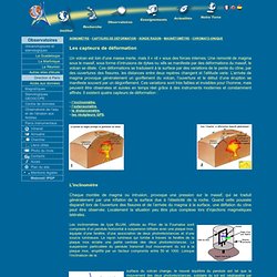
Une remonté de magma sous le massif, sous forme d’intrusions de dykes ou sills se manifeste par des déformations du massif, le volcan se dilate. Ces déformations se traduisent à la surface par des variations de la pente du cône, par des ouvertures des fissures, les distances entre deux repères changent et l’altitude varie. L’arrivée de magma provoque généralement un gonflement du volcan, l’ouverture et le début d’une éruption se manifeste souvent par un dégonflement. Ces variations sont très faibles et invisibles pour l’homme, mais peuvent être observées et suivies en temps réel grâce à des instruments modernes et constamment affinés. . - l’inclinomètre, - l’extensomètre, - le distancemètre, - les récépteurs GPS. L'inclinomètre. 1/30/1997 eruptive event on Kilauea. 1/30/1997 eruptive event on Kilauea Continuous GPS measurements preceding the January 30, 1997 eruption on Kilauea volcano, Hawaii constrain the temporal evolution of deformation associated with dike propagation in unprecedented detail [Owen et al., 2000].
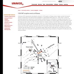
Figure 1 shows the horizontal displacements spanning the intrusion/eruption as determined from a combination of campaign and permanent GPS data. Rift extension due to dike emplacement and contraction due to deflation of a shallow magma chamber beneath the summit of Kilauea are clearly visible in the data. The dike inferred from nonlinear inversion of the GPS data is 2.0 m thick, aligned with the surface fissures, and dips steeply to the south. [Owen et al., 2000] showed that extension between the GPS stations NUPM and KTPM (Figure 2) began nearly coincidentally with the onset of tremor, approximately eight hours before the eruption. Owen, S., P. Segall, P. Volcano Monitoring Techniques. Measuring the temperature of lava is one method used to monitor volcanic eruptions.
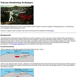
Photograph by R.L. Christiansen, U.S. Geological Survey, January 9, 1973. Lesson at a glance, Key Concepts, and Lesson Outcomes are available by clicking here. Background: Geologists have developed several methods to monitor changes in active volcanoes. Ground Movements Tilt is a measure of the slope angle of the flank of the volcano. insert: Prior to any change in the volcano, a balance is reached between the outward (mostly upward) pressure of the magma in the reservoir beneath the summit and the downward weight of the rocks above the magma reservoir. GPS. On peut surveiller la déformation du cône d'un volcan en activité grâce à l'utilisation de récepteurs GPS positionnés sur le cône.
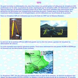
La position du point, représenté par le récepteur GPS, est déterminée à l'aide de signaux émis par 28 satellites tournant autour de le Terre. Seul trois satellites sont nécessaires pour permettre de déterminer par triangulation la position du point. Comme pour le distance-mètre, les conditions météorologiques et stratosphériques ont des influences sur la précision de la position. Voici un récepteur GPS et l'utilisation qui en a été faite en 1997 sur le Kilauea (Hawaii) : Kilauea Volcano, Hawai`i : Deformation. Note: Check the Photo Glossary or a good dictionary for any terms unfamiliar to you.
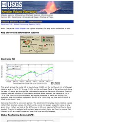
This graph shows the radial tilt at Uwekahuna (UWE), on the northwest rim of Kīlauea's caldera, and at Pu`u `Ō `ō cone (POC), on the northwest flank of the active vent along the east rift zone, as recorded by continuously operating electronic tiltmeters. Positive changes indicate inflation of the magma storage areas beneath the caldera or Pu`u `O`o. The Y-axis is in microradians, an angular measure in parts per million; for example, one microradian represents the tilt of a 1-km-long bar, one end of which is lifted up or down 1 mm.
Data are shown for a one-week period. The electronic tilt display shows relative values rather than absolute values. This graph shows the change in distance between two Global Positioning System (GPS) stations located on opposite sides of Kīlauea's caldera. Eruption-viewing opportunities change constantly, so refer to this page often.