Cartography Tools. A collection of world, country and city maps - Mapsof.net. Chart and image gallery: 30+ free tools for data visualization and analysis. November 7, 2013 03:21 PM ET The chart below originally accompanied our story 22 free tools for data visualization and analysis (April 20, 2011).
We're updating it as we cover additional tools, including 8 cool tools for data analysis, visualization and presentation (March 27, 2012) and Six useful JavaScript libraries for maps, charts and other data visualizations (March 6, 2013). Click through to those articles for full tool reviews. Features: You can sort the chart by clicking on any column header once to sort in ascending order and a second time to sort by descending (browser JavaScript required). Skill levels are represented as numbers from easiest to most difficult to learn and use: Users who are comfortable with basic spreadsheet tasks Users who are technically proficient enough not to be frightened off by spending a couple of hours learning a new applicationPower usersUsers with coding experience or specialized knowledge in a field like GIS or network analysis.
My Content. Vacation locations: How to make a story map with photos, text, map. Real-time snow report map for skiers and snowboarders. Demographic Analysis in a single click. 7 Ways To Make A Google Map Using Google Spreadsheet Data. If you maintain a lot of data in Google Spreadsheet, you’ve probably at least once thought, “Hey, I should be able to get all those locations and quickly plot them in a Google Map”.
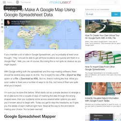
Well, you can of course. But doing this is not quite as obvious as you might expect. With Google writing both the spreadsheet and the map-making software, there should be several easy ways to do this. You’d expect to see a File > Export as Map option or a File > Download as KML. But no, there’s nothing like that. I’m sure you’ve done this before. Google Spreadsheet Mapper For many years now, Google has been revising its Spreadsheet Mapper tool in order to give you an easy way to create KML files for Google Earth maps and matching URLs for Google Maps. What is great about this method is that you can change the styling easily and produce map location data that looks fabulous.
Also, don’t try anything smart with the Spreadsheet Mapper, like importing data from another spreadsheet automatically. Untitled map. Instant Google Street View (QSView) @ 40.76624,-73.96751. Maps.stamen.com. For over a decade, Stamen has been exploring cartography with our clients and in research.
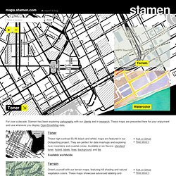
These maps are presented here for your enjoyment and use wherever you display OpenStreetMap data. Toner These high-contrast B+W (black and white) maps are featured in our Dotspotting project. They are perfect for data mashups and exploring river meanders and coastal zones. Available in six flavors: standard toner, hybrid, labels, lines, background, and lite. Available worldwide. Terrain Orient yourself with our terrain maps, featuring hill shading and natural vegetation colors. Available in the USA only. Watercolor Reminiscent of hand drawn maps, our watercolor maps apply raster effect area washes and organic edges over a paper texture to add warm pop to any map. Burning Map The roof, the roof, the roof is on fire!
Requires a WebGL-enabled browser, such as Google Chrome. Mars?? Yes, Mars. Trees, Cabs & Crime Trees, Cabs & Crime started off as a weekend hack and ended up in the Venice Biennale. ModestMaps. How to Create a Google Map With Excel Data and Fusion Tables. GeoFRED: Geographic Federal Reserve Economic Data. GOS - Geospatial One Stop. The Collection. Google Maps Transparencies. Interactive. The World of Seven Billion The map shows population density; the brightest points are the highest densities.
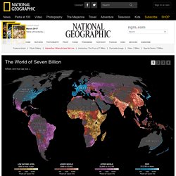
Each country is colored according to its average annual gross national income per capita, using categories established by the World Bank (see key below). Some nations— like economic powerhouses China and India—have an especially wide range of incomes. But as the two most populous countries, both are lower middle class when income is averaged per capita. MapAList - Create and Manage Maps of Address Lists. ArcGIS Explorer Online. Online vector map creation. OpenStreetMap. Library of Congress Maps Collections. The Library of Congress Search by Keyword | Browse by Geographic Location Index | Subject Index | Creator Index | Title Index The Geography and Map Division of the Library of Congress holds more than 4.5 million items, of which Map Collections represents only a small fraction, those that have been converted to digital form.

The focus of Map Collections is Americana and Cartographic Treasures of the Library of Congress. These images were created from maps and atlases and, in general, are restricted to items that are not covered by copyright protection. Map Collections is organized according to seven major categories. Searching Map Collections The mission of the Library of Congress is to make its resources available and useful to Congress and the American people and to sustain and preserve a universal collection of knowledge and creativity for future generations.
The Library of Congress presents these documents as part of the record of the past. Special Presentations: Places in History. Create Maps.